
Here we present selected parts from the very informative paper titled “The Mycenaean drainage works of north Kopais, Greece: a new project incorporating surface surveys, geophysical research and excavation“, by E. Kountouri, N. Petrochilos, N. Liaros, V. Oikonomou, D. Koutsoyiannis, Ν. Mamassis, N. Zarkadoulas, A. Vött, H. Hadler, P. Henning, T. Willershäuser.
“The attempt to drain the Kopais Lake was one of the most impressive and ambitious technical works of prehistoric times in Greece. The size and the importance of this achievement inspired myths and traditions referring to its construction and operation, as well as to its final destruction, which has been attributed to Heracles
(Diod. Sic., 4.18.7 “… but in Boeotia he did just the opposite and damming the stream which flowed near the Minyan city of Orchomenos he turned the country into a lake and caused the ruin of that whole region. But what he did in Thessaly was to confer a benefit upon the Greeks, whereas in Boeotia he was exacting punishment from those who dwelt in Minyan territory, because they had enslaved the Thebans ….”).
Mycenaean Boeotia and the Kopais Lake
Being located on the crossroads connecting the Peloponnese and Attica to the north of Greece, Boeotia is one of the most important regions of Mycenaean Greece (1600-1100 BC), as borne out by the finds from excavations and its significant place in mythology and ancient traditions.
Excavation evidence and historical tradition attest (e.g. Bulle 1907; Iakovidis 1995) that the most important centre in northern Boeotia was Orchomenos, lying in the northwest corner of the Kopais lake/plain. A mainland and primarily a lakeside power, Orchomenos turned its attention mostly towards central Greece aiming for the control of the unique natural resources at hand. Overseas relationships do not seem highly important. The sporadic archaeological investigations in Orchomenos have brought to light only few remains of the Mycenaean settlement. The finds, however, indicate its special flourish. (Schliemann 1881; Papazoglou-Manioudaki 1990)

(Photo: Façade of the Mycenaean tholos tomb of Minyas at Orchomenos)
The enormous installation of Gla (e.g. Iakovidis 1983; 1998) built on a natural island in the east creek of the lake is located close to Orchomenos. The citadel was constructed in the early thirteenth century BC by Mycenaeans from Orchomenos, along with the works for the drain of Lake Kopais. It is girt by a Cyclopean enceinte pierced with four gateways; remnants of large buildings, clearly palatial, can still be seen. The constructions on the citadel (Cyclopean wall, residences of officials and granaries) were built contemporaneously. This ensemble has been interpreted as part of an ambitious plan for supervising the drainage installations, as well as collecting and storing the production of the plain. Gla was destroyed in the late 13th century BC.

(Photo: Aerial photograph of the citadel of Gla)
The main hydrosystem components of Lake Kopais
The Boeotian Kephisos River, flowing from northwest to southeast, is discharged at the south-eastern edge of the local basin. Having no outlet to the sea, the concentrating waters of the river formed the Lake Kopais. This body of water either evaporated or drained through several sinkholes in the eastern part of the basin. The basin represents a structural polje of intra-mountainous tectono-karstic depression in a limestone region (Tsodoulos et al. 2008). The polje is well known as a geoarchive for high-resolution palaeoclimatological proxies spanning the period since the mid Pleistocene (Tzedakis 1999; Griffiths et al. 2002). During the winter, the minimal evaporation coupled by the limited discharge capacity of the sinkholes led to the increase of depth, area and storage of the shallow Lake Kopais. On the contrary, the lake decreased in summer, occasionally in a quite spectacular manner.

(Photo: Topographic overview of the Kopais Basin in Boeotia with the location of the main river courses)
The Kopais basin hydrosystem also includes Melas River, which is supplied by the homonymous springs of mount Akontion and is discharging in karstic sinkholes of the northeastern fringe of Kopais basin. Spring altitude varied between 97.70 m and 101.50 m, whereas discharge varied from 2.80 m3/s to 5.30 m3/s (88.0 – 166.6 x 10⁶ m3/year) (Xanthopoulos et al. 1990). The local hydrosystem also comprises Erkyna, Pontza and several other small streams, flowing mainly from the south of the basin, as well as a variety of springs. The mean total annual discharge of the springs of the Boeotian
Kephisos is currently about 300 x 106 m3/year, but it used to be higher at the beginning
of the 20th century (about 380 x 106 m3/year). The altitude of the lake’s bottom was 84
m a.s.l. and it did not exceed 92 m a.s.l. in its greater part. The water level of the lake
was determined by the elevation of the sinkholes, usually not exceeding 97 m a.s.l. The
lake covered an area ranging from 150 km2 to 250 km2 (Constantinidis 1984). During the
floods of 1852 and 1864, water level exceeded 97 m, resulting in the flooding of about
20 km2 of the neighboring Levadeia basin, whereas the year 1856 drought led to the
complete draining of the lake.
Prior to the construction of the 19th century drainage infrastructures, the Boeotian
Kephisos emerged from the mountain valley onto Kopais river basin at Pyrgos, NE of
Skripou – Petromagoula, joining the Melas river bed. The combined flow was slowly
accumulated towards the great sinkholes of Kephalari, south of Topolia village. The
Mycenaean drainage works were exactly based on this natural mechanism. Hence, the Mycenaean inhabitants of Orchomenos, in their efforts to secure arable land, must have realized that their main purpose should be to convey the combined discharge of Boeotian Kephisos and Melas away from the Kopais basin, towards the sinkholes to the
northeast.
Subsequent attempts to drain Kopais: historical notes
The cartographical and topographical surveys conducted by the French and English engineers of the companies that undertook the works to dry up the Lake have brought ground in the study of the Kopais’ basin history (for the previous research in Kopais see Curtius 1892, Kambanis 1892, Kambanis 1893, Kenney 1935; Kahrstedt 1937; Wallace 1979). The impressive remnants of the Mycenaean hydraulic works that were discovered represent the most important land reclamation effort of prehistoric Greek antiquity, reasonably attracting the attention of the international scientific community. Nevertheless, in spite of the minor or extended surveys that followed (e.g. Lauffer 1938/1939; 1939; 1940; 1985; 1986), the picture of the prehistoric drainage works in Kopais had remained ambiguous. The theories (Knauss et al. 1984) that have been proposed concerning the function and the precise date of the works within the Bronze Age, were based solely on indications from surface survey and not on data stemming from archaeological or geophysical research methods. Furthermore, the representation of the operational scheme of the Mycenaean hydraulic works is admittedly a quite difficult task: these works coexist with (i) several subsequent and possibly incomplete attempts to drain the lake over the centuries (e.g. Oliver 1971; Oliver 1989; Boatwright 2000), plus (ii) the existing 19th and 20th century drainage infrastructures.
The New Kopais project: first fieldwork results
The new interdisciplinary project focusing on the interpretation of the Mycenaean
drainage works, is realized by the Hellenic Ministry of Education and Religious Affairs,
Culture and Sports in collaboration with the Department of Water Resources and
the Environmental Engineering of the National Technical University of Athens
(Greece) and the Institute of Geography of the University of Mainz (Germany). The
project aspires to answer several queries about the technological background of the inspired technical work in Kopais. Additionally, a series of hydraulic and hydrological
analyses attempts to extract the exact operational scheme of the works. The field works, undertaken during the summer of 2011, comprise archaeological surface survey,
topographical mapping, geophysical survey, subsurface sampling of soils and
three-dimensional terrestrial laser scanning, all combined with exploratory archaeological excavations in selected areas. The results of the first field season provided new evidence on the construction, the course, the size and mainly the dating of the Mycenaean hydraulic works.
Starting from the focal point of the segments of the wall excavated by the first author at the site of Anteras, the Mycenaean levee walls were traced and mapped west, towards Orchomenos, for a length of 2.5 km, and east, in the direction of the village Kastro, for 8.5 km. In addition, the Pyrgos, Stroviki, and Tourlogiannis hills were explored for possible auxiliary installations of the Mycenaean hydraulic works, such as guard posts or small forts. At the same time, smaller drainage works and man-made water storage areas postulated by other scholars (Knauss 1984) were sought in the entire aforementioned region.
Several initial findings were verified by the preliminary hydrological analysis and the
geoarchaeological research. The geo-scientific studies carried out in the Kopais basin
by the Institute of Geography of the University of Mainz comprised of vibracoring using
an Atlas Copco Cobra mk 1 coring device. The maximum recovery depth reached 7 m below surface with core diameters of 6 and 5 cm. Photo-documentation, description and sampling of the retrieved cores were carried out in the field. Core description included the analyses of grain size, sediment colour, calcium carbonate content and noticeable features such as plant and macrofaunal remains or ceramic fragments.. For the geochemical analyses, X-ray fluorescence measurements (XRF) were carried out during fieldwork using a hand-held XRF analyzer [type Thermo Niton Xl3t 900S, calibration mode SOIL]. Measurements were taken every 5 cm, wherever possible, in order to ob-tain a detailed vertical distribution pattern for the stratigraphical record. Earth Resis-tivity Tomography [ERT] measurements were carried out at different locations to detect buried segments of the Mycenaean wall and/or sedimentary structures below present ground surface. ERT transects were orientated perpendicular to the assumed course of the levee according to the survey that had been preceded. The position and elevation of the coring sites and the ERT transects were measured (by means of a TOPCON HiperPro FC-250 DGPS device), and the older stratigraphical excavations, can be set forth.
An initial overview based on the findings of the first field season
First, at the site of Romeiko, around 2.5 km northeast of Orchomenos, one of the two branches of the lower reaches of Boeotian Kephisos River was diverted from its old bed to a new one, shared with the Melas River; the second branch of the Kephisos continued to flow into the western margin of the Kopais basin. This diversion is likely to have been the work of the Mycenaeans. By diverting part of Boeotian Kephisos and Melas Rivers towards the sinkholes existing along the banks of the basin, the water level and the area of the lake were reduced; consequently, the northern portion of the basin could be turned over to cultivation.
Second, the diversion was accomplished with the aid of a robust levee, carved in a west-east direction, from the area of Orchomenos towards the sinkholes of the north-eastern cove. The levee ran along the northern edge of the lake, in proximity to the limestone slopes of the basin. It was also setting the boundaries of the region flooded by the waters of Boeotian Kephisos and Melas Rivers, before these were being emptied into the sinkholes. In effect, the levee worked as a barrier and water retention dam at possibly the highest rim of the basin, allowing the land on the other side to be dry for agricultural exploitation.
Third, in the portion that was investigated, the levee’s course appears to follow, in parts, the modern country road linking Kastro and Orchomenos, as well as a farm road leading towards the village of Pyrgos. The remains of the levee discovered during the modern widening of the country road between Kastro and Orchomenos, as well as the stratigraphy of the excavations taken place in the site of Anteras, confirm the aforementioned course.
Fourth, the constancy of the water supply of the Melas River in yearly terms made it suitable to be used for irrigation and in domestic settlements, without requiring more complicated artificial reservoirs for floodwater retention. Further investigation is needed in order to certify whether the Mycenaean infrastructures included the construction of polders and artificial reservoirs for floodwater retention and storage.
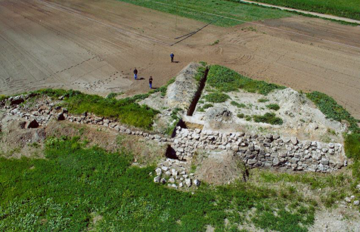
(Photo: View from the North of the northern retaining wall of the levee)
Fifth, the exterior sides of the levee are consolidated by strong retaining walls, built in the Cyclopean masonry style. These walls improved the resistance of the levee to the pressure of the water and hindered the erosion of the soil. At the same time, they provided a strong retaining infrastructure for the possible construction of a road along the top of the levee, by the creation of an artificial plateau. The exterior face of the retaining wall is sloped at an angle of 78 degrees; the stones of the lower courses protrude markedly from those of the upper courses. The well-built walls are preserved to a height of 2.30 m, having a width of 1.78 m at the top and 2.78 m at the base.
Given the quantity of stones found in the destruction layers, an original height of over 3m can be postulated. The walls were created using large boulders placed in roughly regular courses, with smaller stone chips used as filling. Initially, a foundation trench was dug consisting of a shallow ditch. This was somewhat wider than the retaining wall and it was filled with small stones set into a thick layer of clay. Above this water-proof insulating infrastructure, the stones of the first courses were laid, supplemented by a clay filling in between the joints. The rest of the retaining wall was constructed on top of this course. Unlike the exterior face of the wall, the interior facade was erected vertically, without any particular aesthetic attention; it was filled with uncut boulders protruding and receding at random, and a thick mass of small to medium stones and clay.

(Photo: Section of the northern retaining wall of the levee)
Sixth, the core of the retaining wall makes extensive use of yellowish clay originating from lake deposits, which is characterized by plasticity and waterproof qualities. A thick and compact layer of this clay, measuring a total of 2 m thick, reaches down to the foundation trench of the retaining wall; the layer was completely devoid of any ceramic material. In a certain case, at the lowest level of this layer of clay, a large stone was found, having fallen from a higher course of the retaining wall. Around it, a small quantity of stone chips indicates that the boulders were roughly hewn on the spot.

(Photo: Stratigraphy of the core of the levee)
Seventh, the retaining walls did not have the same dimensions everywhere. These were often dictated by the geomorphology of the area and proximity to the limestone slopes and the sink holes. The total width of the wall at the site of Anteras, including the two Cyclopean segments which marked its northern and southern long sides, measures 30 m.
Eighth, the second retaining wall, on the side facing the dry valley, is often omitted. In these cases, the width of the wall is much smaller.
Ninth, a terminus ante quem for the chronological determination of the construction of the retaining wall is provided by the cemetery found at Stroviki. The site is located at a level lower than that of the foundation trench, and dates to the MH period (Aravantinos et al. 2006). In addition, the investigation of undisturbed layers of fill have provid-ed ceramics which clearly place the period of construction and use of the correspond-ing portions of retaining wall in the LH IIIB period (the middle of the 13th century BC). It is thus confirmed that they belong to the same chronological horizon as that of the citadel at Gla.
(…)
It should be stressed that a technological work of such a scale required extensive excavations and removal of huge quantities of earth, not to mention the quarrying, transport, processing and lifting of such large boulders for the building of the retaining walls. The fact that the stones for the construction of the retaining walls seem to have been hewn in place requires organized teams of personnel with clear and distinct responsibilities; at the same time, it presupposes the existence of a steady flow of supplies. All of the above support the case that there must have been a particularly strong and centralized authority in the region.”
We continue on the subject by presenting selected parts from the very informative paper titled “Representing the operation of ancient reclamation works at Lake Copais in Greece“, by Mamassis N., S. Moustakas and N. Zarkadoulas.
“In ancient times, the civilizations that prospered in the Greek peninsula made a remarkable progress in understanding water – related processes. Also in many cases, they developed integrated systems, which were consisted of large or smaller hydraulic works. These works served the fundamental water needs, such as water supply (for urban use or irrigation), land and urban drainage, flood prevention, sanitary facilities and urban sewage. In the island of Crete, during the Minoan period (3500-1200 BC), a technological step happened regarding water capture, conveyance and utilization. The archaeological investigation in the palaces of Knossos, Phaistos and Malia, which were the center of life for the Minoans, revealed very important hydraulic infrastructures. Systems for water transportation, wastewater and stormwater management and bathrooms with flashing toilets, have been found. Sewage systems as well as bathrooms and bathtubs were also found in the island of Thera the major center of the Cycladic civilization.
As ancient societies were developed, the agricultural production became more important. The hydraulic works, which secured crop irrigation, were related to water capture, storage and conveyance. Agricultural lands had to be protected from flooding and in specific cases, new areas were reclaimed by drainage (Koutsoyiannis and Angelakis, 2007; Mariolakos 2009). Considering that Greece had always been an extremely fertile area, therefore suitable for a wide variety of agricultural activity, the importance of such hydraulic works is obvious.
Lake Copais, is located in Central Greece, and was partially drained during 13th century BC. A portion of the water volume of the main rivers that fed the lake diverted towards natural karstic sinkholes and finally to the sea. According to Strabo (IX 406-407, 414-415), drainage works were made by Minyans, inhabitants of Copais area during the Mycenaean Period (1550-1150 BC). Historical investigation makes clear that Minyans were very willing to develop commercial relationships with other Greek races, and acquired great wealth and power. However, they focused primarily to control the unique natural resources of their territory and then to develop trade relationships (Kountouri et al, 2013). The works date in the late Mycenaean period, probably around 1400-1300 BC, a period that Minyan civilization reached its peak.
Important elements of ancient Copais drainage system came during the construction period of the modern system from the English company ‘Lake Copais Company Limited’. Since then, the Minyan hydraulic works attached the attention of the scientific community. Several studies on ancient Copais drainage system have been carried out by several researchers (Rachet, 1993; Schnitter, 1994; Knauss, 1995; Knauss, 2000). Knauss, 2000, characterized the Minyan works as “extraordinary and ingenious”. He also claimed that the “first hydraulic civilization of Europe” was born in the Mycenaean Copais and suggested that this area was the ‘‘fat province’’ of Boeotia, mentioned by Homer in Iliad, Book 7 (219–224).
According to Knauss, 1995, Minyans attempted to gain land from Copais Lake in two main phases. Initially, low but extended earth dams were constructed. These dams enclosed land (polders) used for agricultural and other purposes. After dams’ failure, perhaps due to intense hydrological phenomena, a second system was developed. The most important structure of this second attempt was a 25 km long canal which carried water from Copais basin to the natural sinkholes located in the northeast part of the area. The canal served three main purposes: – It reduced and stabilized the water level of Copais Lake in order to gain land for agricultural use and settlements. In addition, the old protective polders were used again even under extremely wet periods.
– It facilitated the water supply of settlements and crops.
– It created an inland navigation scheme along the northern part of the basin, facilitating the transport of merchandise from the harbors close to the northeastern edge of Copais, to the major city of Orchomenos.
Minyans’ land was the greater area of Copais basin in Boeotia. Although their capital was Orchomenos (at the east of Copais basin), in the early 13th century BC Minyans built a citadel at Gla hill, which was surrounded by cyclopean walls. Gla was a palatial place and it was located at the northeastern part of Copais basin, close to the sinkholes. Remnants of granaries and officials’ residences have been found there. It is assumed that these facilities were used by Minyans to storage the harvest and to supervise Copais’ water management system.
In ancient time, Boeotian Kephisos, the largest river in the study area, entered Copais plain from the west and as it could not find a way out, outpoured to the southeast part of plain. There, it created an extensive shallow lake, the size of which intensively varied in time, depending mainly by river’s discharge. Meanwhile, Melas River, flowing along the northern part of the basin, discharged through the sinkholes of the north – eastern edge. The water sunk into those sinkholes and reappeared at the North Euboean Gulf. Minyans assumed that if both Kephisos and Melas rivers discharged to the sinkholes, the lake’s size would greatly be reduced and become stable. The hydraulic works aimed at:
– Reclaiming land from the eastern part of the lake for cultivation
– Protecting these areas from floods
– Increasing the draining capacity of the sinkholes
– Supporting the irrigation works The main interventions by the Minyans are presented in the following Photo and included:
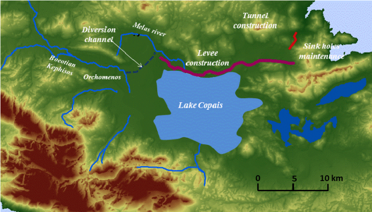
– A diversion channel in order to convey a portion of Kephisos water discharge to the karstic sinkholes at the northeastern edge of the basin
– A levee in the northern part of the basin in order to protect the irrigation areas from of Kephisos and Melas River’s floods
– A tunnel which was constructed (not completed) very close to the natural sinkholes. Th tunnel drained the water volume, which was accumulated in the sinkhole area, towards the sea
– Cleaning and maintenance works for the sinkholes so that their draining capacity was ensured
– Water cisterns in order to ensure that their irrigation needs will be fulfilled even during dry seasons.
Minyans first constructed a barrier in order to divert Kephisos (its largest part) from its natural course to an artificial channel towards Melas River’s riverbed. This possibly was located about 2.5 km south of the city of Orchomenos, although remnants of the diversion levee have not been found until today. So, Kephisos joined Melas (probably about 3 km north of Orchomenos) and the two rivers continued together their course towards the sinkholes. In order to reduce the possibility of a flood due to water overflow, Minyans constructed a strong levee south of Melas riverbed and almost parallel to it. This levee’s direction was from the west to the east, and it was the boundary between the flooded part of Copais (north part) and the cultivated one (south part). The construction technique of this “barrier” is one of the most impressive elements of ancient Copais reclamation system (Kountouri et al., 2013). Some technical characteristics are given below:
– The exterior sides of the levee were reinforced by cyclopean retaining walls. The main purpose of these walls was to prevent, as much as possible, the levee’s erosion. Additionally, they increased its resistance to water pressure.
– For the construction of the retaining walls, large boulders were placed externally into layers more or less having the same height, while smaller stone were used inside. The interior of the walls was filled with yellowish clay. This clay was found in large quantities in the former lake bottom, as it was carried by water flow. It is characterized by its high plasticity and waterproofing properties. The above construction technique is similar to the modern way of building earth dams and it demonstrates solid knowledge. Minyans known the materials’ properties and the characteristics of erosion process.
– The phases of building a retaining wall was the following: First, the Minyans dug a trench foundation, a little wider than the wall. The trench was filled with a thick layer of clay in which small stones were placed. This structure was waterproof due to the clay. The stones of the first layers were placed above it (with the clay between them as a flange) and the upper layers were constructed on top.
– The exterior side of the wall inclined and the boulders of the lower layers were extended more than the higher ones. In contrast, the inner side of the walls was almost vertical.
– The proper construction of the retaining walls, allowed them to reach up a height of 2.3 m in some cases, while the stones which were found around them, indicate that their original height was about 3.0 m. Their width varied because of the geomorphology of the surrounding area and the proximity of the walls to the slopes of the basin.
– About 6 km east of Orchomenos, the total width of the levee and its two retaining walls was approximately 30 m. Excavations which have been carried out have revealed several positions of the ancient levee. Although it was constructed before 3.000 years, is generally in good condition and still has keep a height over 2 m and a width over 10 m. Nowadays, Copais is a fairly smooth plain without especially acute morphological changes, so the contrast between the flat terrain and the bulky levee is intense. Using aerial photographs and satellite images of Copais, we can find out the traces of the levee to the ground. After a detailed study of the available data, we approximately determined the course of the Minyan levee and we estimated its total length to about 22 km.
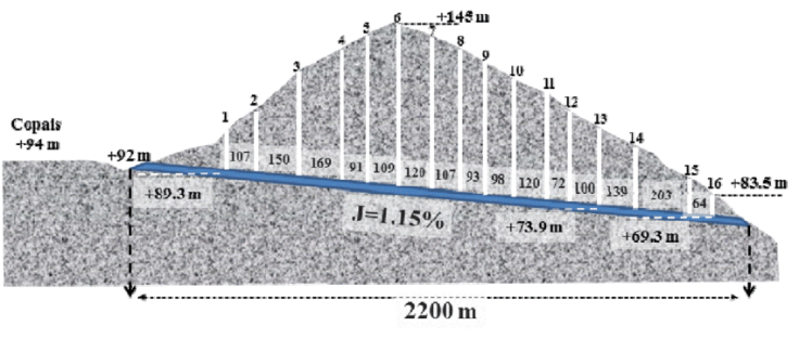
The drainage system could not entirely be depended on the sinkholes, as the supervision of their condition, especially in their deepest parts, was a difficult task. So Minyans attempted to dig a tunnel in the site of Kephalari, which was very close to the sinkholes. This tunnel was designed to divert water of B. Kephisos and Melas rivers to a small torrent and finally to Euboean Gulf. Its function was similar to the sinkholes and it enhanced the drainage of the basin. Its length was scheduled to be over 2.2 km with a continuous slope of about 1.15% (Kambanis, 1893). It had a cross section of 1.45 m width and 1.55 m height, while its discharge was 7 m3/s approximately. To supervise the construction and operation of the tunnel, 16 vertical shafts were dug with a total depth of about 650 m (Figure 5). Recent exploration revealed that finally, only about one – fifth of the tunnel was completed. In addition, most of 16 shafts never completed and some of them gradually backfilled. The tunnel starts from a sinkhole, continues for about 400 m and suddenly stops (under the shaft 3) to a solid rock. Another proof of the tunnel’s unsuccessful construction found at the bottom of shaft 14, where the tunnel has been dug to both directions for 7 m and stops to solid rock. The ceiling of the tunnel was constructed as a relieving triangle over lintels that distribute the weight into the supporting walls. That was a classical Mycenaean technique.
Comparing Minyan’s water needs with the combined water volumes of Boeotian Kephisos and Melas rivers we realize that, except from the summer months, the rivers discharges were sufficient for their needs. During summer there was a shortage in water resources and at that period, Minyans could retrieve the water which was stored in the lake in order to irrigate their fields. Kephisos and Melas rivers flowed in higher levels compared with the cultivated land and the lake water resources were in lower levels. So, it is reasonable to assume that Minyans preferred to use the river flow as it would allow them to irrigate very easily using gravity. Thus, artificial cisterns, which stored small water quantities during winter, could be part of the Minyan water management system. Cisterns provided irrigation water using gravity, during dry summer periods.
A possible location of an artificial cistern was found about 6 km east of the city of Orchomenos. At that site, the route of levees unexpectedly curves without any obvious reason (like e.g. terrain morphology). Perhaps this design served the creation of an area where water could be stored in order to be exploited during dry periods. If the slope of the ground was suitable, water could be stored in an area of about 1.5 km2. As the height of the levee was about 3.0 m, approximately 4.5 hm3 of water could be stored in the above location. Moreover, it is possible that this curve also served as the system’s spillway.
The most important operational decision that Minyans had to take was the monthly water quantity which had to be diverted from Kephisos and Melas to the sinkholes. This monthly water volume was expressed as a portion of the total monthly discharge of the rivers.
Summary
– In order to keep the lake Copais under the level of 95 m a large amount of water has to be diverted into the sinkhole area.
– The operation of the sinkholes includes the control of the accumulated water in order to achieve the maximum exploitation of sinkhole capacity (especially in summer months) but the accumulation volume had to be limited down to100 hm3.
– The withdrawal from the lake during irrigation period is inevitable. That leads to the idea that some small quantities of winter discharges could be stored in small cisterns at the edges of irrigation areas in order to succeed irrigation under gravity.
– The need to construct works in order to remove more water from the sinkholes area is obvious. So, clean sinkholes must have been an important task and construction of the tunnel would be necessary.
Evaluation of sediments
It is obvious that nowadays the geomorphologic characteristics of the Copais lake area are not the same as 3000 years ago. The large amounts of sediments that were transferred during this period must have changed the bottom of the lake. In order to have a gross estimation of this parameter, a calculation of sediment transport was performed. We estimated the sediment transport using a formula developed for Greek basins (Koutsoyiannis and Tarla, 1987), which takes into account the precipitation regime and the geological formation of the area. A value of 500 t/km2 was calculated for the area and we considered that about 1000 km2 of the higher part of the basin were eroded. So a total volume of about 1500 *106 t of sediments must have been transported to the lower areas of the basin during the 3000 years period. The average sediment density was considered 1.2 t/m3, so the total volume of the sediments is estimated to be 1250 hm3. This volume covered the lower parts of the basin, including Lake Copais an area that is estimated to be 900 km2. If the sediments distributed equally over the lowlands area an average increase of 1.4 m to the altitude after 3000 years is reasonable. The lake is located at a distance from the rivers and the sediments mainly deposited to the upper Kephisos basin, so we suppose that the lake area 3000 years ago was about 1 m lower than today.
System operation
The key challenge for the Minyans was to secure the cultivation of flood plains above 97m and to reclaim the areas between 94-97 m. The area between 97 and 100 m is about 40 km2 and the reclaimed area between 94-97 m is about 63 km2. Therefore, the total area available for cultivation is estimated to be more than 100 km2. To reclaim land from Copais Lake, Minyans constructed the levee in order to divert huge amounts of river discharges into the sinkholes’ area.
The results of the hydrological simulation prove the difficulty of the complete drainage of the lake. Although during long periods of hydrological drought the lake recessed significantly, it rarely drained totally. On the other hand, it is possible that during long wet periods some areas around 94-95 m were temporarily flooded. This result is compatible with the works of Rachet (1993) and Schnitter (1994). Both studies come to the conclusion that Lake Copais had never been completely drained by the Minyans. Minyans continuously struggled to keep water level of both lakes as low as possible. The main operational decision was the amount of water, which had to be diverted towards the sinkholes. According to previous operational cases, operational rules that could achieve this task might have been applied. Additionally, Minyans could change the operational rules in specific time periods in order to improve the performance of the system. An important factor of the system performance was the capacity of the sinkholes which is strongly relevant to the accumulation of water towards the sinkholes’ area. Also, the permanently reclaimed areas, were analogous to the sinkhole capacity. It was the reason why the Minyans (or their descendants) made efforts not only to clean regularly the sinkholes but also to increase the amount of water that could be extracted from the hydrosystem. To complete that task they constructed the tunnel at Kefalari.
This study indicates that water level variations (reflecting wet and dry periods) were essential for prosperity of the Minyans. As a result, they constructed these extensive hydraulic works, to control their aquatic environment. Minyans’ reclamation project is admirable as it is the most ancient in the world and equals to modern ones.”
Research-Selection: Philaretus Homerides

An excellent post and incredibly interesting research! May I have your permission to guest post this on your behalf on my blog, theShieldofAchilles.net? I would be quite honored and would, of course, include live links to this original post as well as your homepage. -Kathleen
LikeLiked by 1 person
Of course! Cheers!
LikeLiked by 1 person
Wonderful! I’ll send you a link when it’s live – Cheers!
LikeLiked by 1 person
It’s live – Once again, thanks very much! Here’s the link: https://theshieldofachilles.net/2019/03/21/hercules-a-forefather-of-hydraulic-engineering-in-mycenaean-greece-guest-post-by-novo-scriptorium/
LikeLiked by 1 person