
In this post we present extracts from three different publications which deal with the very interesting posibility that a number of Chinese monuments had been built with the use of a magnetic compass.

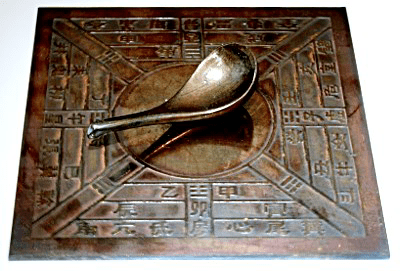
Introduction and Motivation According to ancient chronicles, a magnetic compass in China has been known since at least the 4th century BC, since the Zhou dynasty (1046-250 BC) (Gui Gu Zi, 4th century BC). A spoon-shaped lodestone placed on a square brass plate with the circle at its centre represents one of the ancient forms of Chinese South-pointers. It was used for divination. In the Song period (420-479 AD), one of its early forms was a small piece of lodestone embedded in the body of a wooden fish with a small needle projecting from it; floating in water, it indicates the South (see e.g., Needham, 1964). We are accustomed to thinking of the magnetic needle as pointing to the North, but in China the Polar Star represented the emperor who faced South on his throne, and so the basic direction was to the South.
More than 1500 years ago Chinese sailors discovered that an elongated piece of lodestone suspended from a thread “magically” pivots until it points South and thus that this stone could act as an aid to navigation on their voyages; the lodestone exhibits this behaviour because it contains magnetite, an iron-rich mineral that acts like a permanent magnet (e.g., Lund, 2007).
Geomancy or feng shui is a mean of divination intended to find the most suitable sites and orientation for establishing cities, streets, palaces, houses, tombs, canals, etc. Practised for millenia it has exerted a profound influence on the face of China’s landscape and city plans. Significant differences can be discerned between European and Chinese landscapes. While the European landscape is typically very multiform, the Chinese landscape is checkered. This would seem to indicate that the use of geomancy (and therefore probably a compass) was widespread for millennia. Chinese history it is known to date back to nearly 5000 BP*¹. Throughout its history, geomancy has made use of different versions of magnetic compasses (the geomantic compass, a divination device called shi in Han times, etc., see e.g., Needham, 1964 or Carlson, 1975).
*¹(NovoScriptorium: Evidently, Chinese history goes back earlier than 5,000 BP. Please check our other articles on Chinese Archaeology)
A geomagnetic pole is that pole defined by the best-fit dipole to the Earth’s magnetic field. The magnetic declination read with a magnetic compass is the angle between the meridian and the compass needle and may be affected by non-dipole contributions that vary over the Earth surface. The position of the geomagnetic North pole with respect to the geographic North pole is changing continuously and notably (Fig. 1). The pole of rotation of the Earth is also changing in time but nearly negligibly. The directions from individual points on the Earth to the geomagnetic North pole are therefore also continuously changing.
Paleomagnetism is a research field which studies the behaviour of the ancient magnetic field of the Earth by means of processing records contained in various materials such as sediments and volcanic rocks. Archeological materials such as baked clay, mud, brick, walls, baked rock, burnt walls, porcelain, ceramics, tiles, pottery, coins, etc. can also be used to retrieve a record from the ancient geomagnetic field. The paleomagnetic pole wandering, computed by geophysicists for the interval of the last 6000 years for the whole Earth, e.g., in McElhinny and McFadden (2000), is shown in Fig. 1. For the localities investigated (Luoyang, Beijing, see http://www.maps-china.com/Xian), one can compute models of the paleomagnetic declination (e.g. Korte et al., 2005) and compare it with the declinations observed from the pyramid orientations.
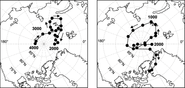 Fig.1
Fig.1
The core of the Fuson hypothesis (Fuson, 1969) is the following: each building is oriented using a compass at the time of its construction or at its last reconstruction and revails information about the direction towards the magnetic pole at that time. Because the geomagnetic field orientation changes in time, we can compare geomagnetic field records with available geomagnetic field models for the same region, and find an associated date.
Thus, we can, at least theoretically, correlate the date of the building construction with its orientation, assuming this was carried out using a magnetic compass. Knowing the orientation of a building and the history of paleomagnetism we can estimate its date, and vice versa. The practical problem is that the paleomagnetic data (and thus also the paleomagnetic declination) is not known to a greater accuracy than a few degrees.
We know that the Chinese used a rudimentary magnetic compass for divination purposes from time immemorias – as Chinese legends tell. The first written record dates from the 4th century BC (Gui Gu Zi, 4th century BC). The relationship between Chinese calendar and our own calendar is also clear. However it remains to be shown that this ancient compass was used also for the orientation of buildings.
Starting from the Qin dynasty (246-207 BC) up to the Qing dynasty (1644-1911 AD) all data concerning Chinese emperors can be counted reliably and accurately, as far as their personal and posthumous names and/or titles are concerned. This includes the dates of their birth (year, month, day), accession to the throne (including abdication and/or deposition) and death.
In the Chinese sources this is derived from a means of Chinese calendar calculation based on the traditional Chinese sexagenary cycle, called jiazi (the 1st year = jiazi to 60th year = guihai). For conversion of chronological data given according to the Chinese yinli calendar, i.e. the year of the birth /reign/death, etc. of the respective emperor plus the month plus the day designated by the combination of the “heavenly stems“ (tiangan) and the twelve “earthly branches” (dizhi), into the Christian calendar (BC, AD) the reader is referred to the following authoritative Chronological Tables (Dong Zuobin, 1960; Jiang Lianfu, 1959; Moule, 1957; Wan Guoding, 1956; Zheng Haosheng, 1936). In short: conversions between the Chinese calendar and our own do not add any additional error to our results. The Chinese calendar is accurate to within a day.
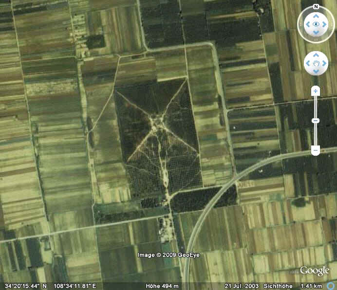
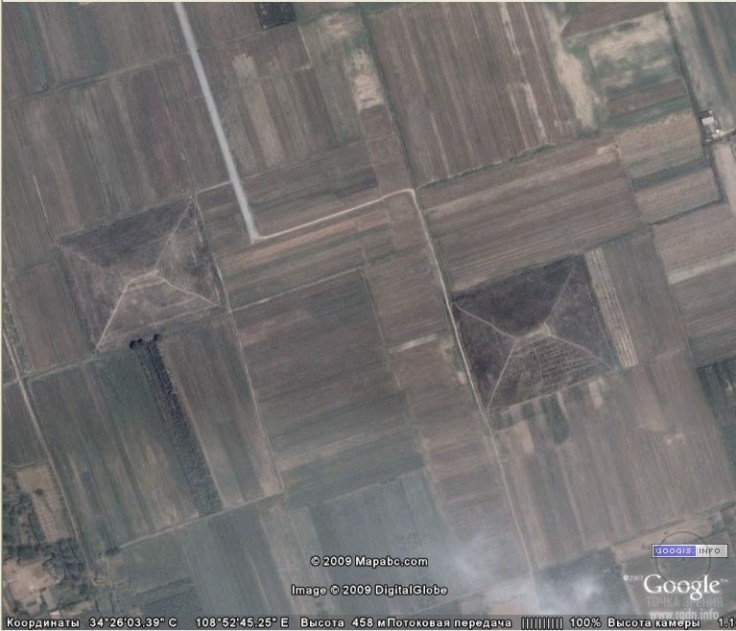
In this paper, we compare and observe paleomagnetic declinations with the available geomagnetic field model calculated at the tombs in the location of central China (Xi’an and Luoyang) aiming to correlate them with the known date (the starting year of pyramid construction) and orientation of “pyramids” in those regions. The strict principle in China was that the “pyramid” had to be built from the second year of the respective emperor reign. This means from the year of accession to the throne +1 year.
The geographic orientation of these “pyramids” was read (observed) from satellite images shown by Google Earth or from http://www.mapschina.com/Xian (Luoyang).
Conclusions The Chinese have been aware of magnetism since the second millenium BC. But the first written record dates from the 4th century BC: “When the people of Cheng (1042-1021 BC) go out to collect jade, they carry a South-pointer with them so as not to lose their way.” (Gui Gu Zi, 4th century BC). The use of the compass in China since 1000 BC was described also by Needham (1964).
The Chinese used the compass not only for landscape design (layout) but also for the alignment of buildings, city walls, streets, palaces, mausoleums, canals, etc. The buildings of tombs (“pyramids”) and also the layout of their wide surroundings bear the stamps of the directions towards the moving geomagnetic North pole in the era of their respective constructions.
There are no indications (extant written records) indicating East and West points at the equinoxes or solstices. The wandering magnetic pole easily explains the „wandering“ found in the orientations of buildings.
Summarizing our method, we can reconstruct paleomagnetic declinations for the region of central China area and the time interval needed from the data of Korte et al. (2005) and compare (correlate) the observed (from Google Earth) orientations of tombs (“pyramids”) with the values of reconstructed paleodeclinations for given (known) ages of the buildings. A correspondence between the model declinations and these orientations was discovered. Although we do not have complete paleomagnetic data to support it, we think the similar small deviations from true North for buildings prior to the Han dynasty could indicate that the magnetic compass was used in China as early as about 3000 BP.
The wandering of the North geomagnetic pole over the past few thousand years has been studied extensively in the past few decades. We expect even better resolution of this wandering history through future research. Together with a better knowledge of actual local (regional) magnetic anomalies and on-site surveys we should have a much firmer answer to this interesting orientation-hypothesis. Donadini et al. (2009) show a paleodeclination curve for East Asia. Their declination values are slightly different from the CALS7K.2 model (Korte et al., 2005) but the curve trends are similar.
Principles of feng shui have been used in China may be since immemorial. Paleomagnetic secular variation data are not (yet) widely available for China (Korte and Constable, 2008). Conversely: it may be possible that the orientations of large and long Chinese constructions (such as city walls, streets, palaces, spirit paths, canals, etc.) oriented along a North-South axis which has been changing through time could be employed as a supplement to customary paleomagnetic research. The results could be better than obtained those from the pyramids: the largest sides of imperial tombs are about 240 m and the sides are sometimes uneven. The above mentioned constructions are up to several kilometres long and they are straight.
(Source: “Chinese tombs oriented by a compass: Evidence from paleomagnetic changes versus the age of tombs”, by Ivanka Charvátová et al.)
Outline Written records indicate that knowledge of an ancient type of compass in China is very old – dating back to before the Han dynasty (206 BC – 220 AD) to at least the 4th century BC. Geomancy (feng shui) was practised for a very long time and had a profound influence on the face of China’s landscape and city plans.
Fuson’s hypothesis has been tested; In China (Xi’an and Luoyang provinces) we had to rely upon satellite images from Google Earth (now with excellent resolution of few meters in many areas).
After eliminating known astronomical and calendar orientation of some buildings, we have found that there is majority of structures with an orientation that clearly deviates from geographic north (pole of rotation of the Earth). When trying to explain this, we can rule out pure chance, local topography, aesthetic, meteorological or defence reasons. The structures might be oriented by means of a magnetic compass.
The use of the compass means that the „needle“ was directed towards the actual „magnetic pole“ (roughly speaking) at the time of construction of the respective pyramid. However, the magnetic pole, relative to the nearly ‘fixed’ geographic pole (the pole of rotation of the Earth), moves significantly over time; changes in its direction ~10 degrees per century, as observed from the given locality, are not exceptional.
By matching measurements of buildings’ orientation with modelled paleomagnetic history, we found a fair correlation between the date of pyramid construction and their space orientation relative to the magnetic pole positions at the respective time of construction. Thus, the Fuson‘s hypothesis can explain the observed sites layout and building orientations in China (Charvátová et al., 2010), in majority cases.
Conclusions The Fuson hypothesis about possible orientation of ceremonial centers by (paleo)magnetic pole, using a magnetic compass cannot be simply rejected in the light of existing facts; it still provides an explanation for the “strange” alignments, where the other interpretation (as astronomical-calendaric) are not helpful. Our measurements and computations from 2003-2010 support this hypothesis for central China. We know that Chinese used a rudimentary magnetic compass for divination purposes from “time immemorias”.
(Source: “Pyramids and Ceremonial Centers in Mesoamerica and China: Were They Oriented Using a Magnetic Compass?”, by Jaroslav Klokočník)

An axis exists, known by the Latins as the “axis mundi” (the cosmic axis), about which the vault of the Heaven seems rotating. This axis, projected on the Earth surface, is giving the cardinal north-south direction. Some ancient monuments show that this axis was considered as very important. The Egyptian pyramids of Giza, for instance, were remarkably aligned along it by the ancient surveyors that used the rising and setting of stars or the shadow of a gnomon to find the true North. The same is true for the Elamite complex of the Dur Untash ziggurat that has the directions of the diagonals less than a degree different from the cardinal directions. Anyway, it is in China that the orientation of building and monuments according to the “axis mundi” became a rule.
It was from the Neolithic times that the settlements were oriented along the north-south direction, in agreement with a solar principle of south-facing entry, prodromal of the theory of Qi, the vital energy that flows in any living thing, and of the Feng Shui geomancy. During the Xia and Shang dynasties, the palaces became a symbolic representation of the cosmos, based on a square layout, oriented strictly north-south, “since Qi flows that direction”. Today, the north-south orientation is considered one of the general characteristics of the Chinese imperial urbanism, that we can easily see in the regular subdivision of the urban sites and consequently in the orientation of the buildings.
Francis John Haverfield (1850-1919), British historian and archaeologist, noted the regular, cardinally oriented, urban planning of the ancient Chinese towns. In his book of 1913, he proposed that these towns were laid out in such a manner according to a very old agrarian system. Actually, the Chinese urban planning is also including symbolisms concerning cosmology, geomancy, astrology and numerology, to have locally the harmony and balance observed in the heavens. And, as we will see in the following discussion, the Chinese architecture is also linked, in some cases, to the Earth’s magnet field.
The phenomenon of magnetism was known since ancient times because of the existence of lodestones. After the observations that oblong objects made of lodestone were attracted by the poles of the Earth, some methods for determining the direction towards them were invented.
“It was not until the time of Shen Kuo” that the earliest magnetic compasses were for navigation. In his written works, Shen Kuo (1031-1095), a Han Chinese scientist and public official of the Song dynasty, made the first known explicit reference to the magnetic compass-needle and the concept of true North. Actually Shen Kuo wrote, “the needle will point south but with a deviation”, and also stated that “[the magnetic needles] are always displaced slightly east rather than pointing due south”. Let us note that Shen Kuo was using an orientation due South, and that, since the needle was displaced slightly east, he was observing, in modern terms, a negative declination (the magnetic declination is the angle on the horizontal plane between magnetic North and true North).
During the medieval period, some very remarkable studies on magnetism existed, in particular those of Shen Kuo on the magnetic declination. Thereafter, the Chinese surveyors were aware of the existence of a difference between the magnetic and the astronomic north-south direction. If we assume, as told in, that Qi is the energy flowing this direction, because of the observed difference, a possible consequence was that of using the compass needle as the best instrument for determining the direction of this flow, because Qi was flowing through the magnetic material. Therefore, if we assume that Qi was considered in the orientation of buildings and architectonical complexes, it is plausible that we can find evidences in the layout of the Chinese architectures of a related surveying made according to the local magnetic field.
As proposed by researchers these evidences exist. Let us remember that the magnetic poles of the Earth move with respect to the geographic poles. Consequently, the magnetic declination, besides depending on the location, is also changing over time.
This use of magnetic compasses for the alignment of so old monuments could be questionable. However, we find mentioned the case of a remarkable architectonical complex; it is the Forbidden City in Beijing, dated from 1406 to 1420 AD. The layout of the Forbidden City was determined by means of a compass “as described (confirmed by some details), e.g. in the correspondence of Karel Slavíček, a Czech astronomer at Chinese imperial court in Beijing”. Besides being evidenced by the historical report, the surveying of the complex by means of a magnetic compass is also in the proper period, that is, after the observations of Shen Kuo on the magnetic declination.
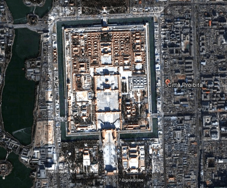
The Forbidden City was created inside the city of Khanbalik or Dadu, the “great capital” of the Yuan Dynasty founded by Kublai Khan. The architect and planner of Dadu was Liu Bingzhong, who was also the architect of Xanadu, the summer capital of Kublai Khan’s empire. The construction of the walls of Dadu began in 1264, while the imperial palace was built from 1274 onwards. The design of Dadu was based on a grid of 9 vertical axes and 9 horizontal axes, and followed the rules of “palaces in the front, markets in the rear”, “left ancestral worship, right god worship” were taken into consideration.
We could ask ourselves if Liu Bingzhong used an astronomical or a magnetic surveying method for Dadu. Of course, it is difficult to deduce it from the streets of that part of the modern Beijing, corresponding to the ancient capital of the Yuan Dynasty. It seems that the streets have a better alignment along the cardinal directions than that observed for the Forbidden City. However, we have the possibility to investigate the layout of Xanadu that was built by the same architect. Xanadu is perfectly aligned along north-south direction. It means that the architect used a survey based of astronomical observations, not on magnetic compasses; of course, this is true if we consider the magnetic declination in Xanadu at the time of its foundation different from zero.
Let us assume the possibility that the architects of Yuan Dynasty preferred a survey based on astronomical observations, such as the rising and setting of stars. We have to consider that the Forbidden City was built by an emperor, Yongle (1360-1424), of another dynasty, the Ming dynasty, which was ruling China after the collapse of the Mongol-led Yuan dynasty. It seems therefore that the new rulers changed also the methods of land surveying, preferring the use of the magnetic compasses, probably because the magnetic compasses were evidencing the flow of Qi.
Another important architectonical complex that was built in Beijing in the same period reinforces this conclusion. It is the Temple of Heaven and its close Circular Mound Altar, which is an outdoor empty circular platform made of marble stones. These are the sites where the emperors of the Ming and Qing dynasties offered sacrifice to heaven and prayed for harvests. Located south of the Forbidden City, the original temple was completed together with the Forbidden City in 1420 during the reign of the Yongle Emperor. We see that we have again a deviation of about 2 degrees, congruent with the use of a magnetic compass for surveying the site. Probably, the surveyors of the Forbidden City and of the Temple of Heaven were the same or used the same method.
Using the interactive map of NOAA (National Oceanic and Atmospheric Administration) we can estimate that, on 1590, the magnetic declination in Beijing was between 3 and 4 degrees, negative. The declination line of 3 degrees moved westward during the period from 1590 and 1650. Assuming the same trend in the period from 1530 to 1590, we can conclude that the magnetic declination in Beijing was, in 1530, of about 5 degrees (negative). This is in agreement with the architectonical results obtained from the Temple of the Earth and the Temples of the Sun and the Moon.
(Source: “Magnetic Compasses and Chinese Architectures”, by Amelia Carolina Sparavigna)

Research-Selection for NovoScriptorium: Philaretus Homerides

It is in point of fact a great and useful piece of info.
I am glad that you simply shared this useful information with us.
Please stay us informed like this. Thanks for
sharing.
LikeLiked by 1 person