
The Intermediate Bronze Age (IB) of the Southern Levant is known as the “Dark Ages.” The large cities of the Early Bronze Age, which were the region’s first urban settlements, collapsed and were abandoned. The complex socio-economic strategies, based on large-scale agriculture, industry, and trade, were replaced by what Dever named “small-scale mixed agro-pastoralism.” This Dark Ages (also termed Early Bronze IV and Middle Bronze I) of pastoral nomadism lasted from ca. 2350 until 2000 BCE, when it was replaced by the urban renaissance of the Middle Bronze Age. The accepted interpretation of the archaeological record suggests that the socio-economic structure of the period declined into a primarily nomadic, tribal society inhabiting small rural villages. The economy is thought to have been based on herding. No evidence for strong central administration has been recovered. Almost no settlement of the period can be described as an urban center and, remarkably, there is no evidence recorded for monumental architecture.

Against this background of pastoral nomadism, the primary evidence left behind by Levantine IB communities is its vast and impressive burial grounds, scattered across the Southern Levant. Among their multiple and varied burial praxes, the use of megalithic dolmens stands out as the most prominent, yet poorly understood, feature of this enigmatic period. Excavation in the Shamir Dolmen Field, located on the western foothills of the Golan Heights, was carried out following the 2012 discovery of engravings in one of the largest dolmens recorded in the Levant. This dolmen revealed evidence of a hierarchical, non-urban governmental system. This new evidence supports a growing body of recent criticism, stemming from new discoveries and approaches, that calls for rethinking our views of the Levantine IB “Dark Ages”.
The traditional approach to understanding social complexity and level of governmental organization in archaeology is based primarily on the magnitude of settlements and the architectural achievements reflected in monumental structures.
The implication, therefore, of the abandonment of settlements and an archaeological record void of large urban settlements and monumental public structures, is the collapse of a cultural system and a socio-political system of low order. History, however, has numerous opposing examples. The largest empire of all time, the Mongolian Empire, was established by small groups of nomadic, tent dwellers. Other highly complex societies left their mark on the landscape not in the form of urban settlements but rather in the shape of ceremonial and religious monuments. The small chiefdoms of Easter Island established a complex and well-organized governmental system. Yet, they left behind not a single urban site. Evidence for their sophisticated culture and organization is found in the famous Moai statues and Ahu stone platforms. The Shamir dolmens tell a similar story about the “Dark Ages” of the Levantine IB.
Megalithic stone structures were built by diverse cultural entities, during different periods, in places ranging from Ireland to Korea. Many attempts have been made to describe and classify this large variety of structures and compounds. Even when the discussion is limited to megalithic burial structures, they still vary in shape, size, rock type, stonemasonry, and architectural design.
In the Levant, large numbers of megalithic burial structures have been found, primarily in Syria, Jordan, and Israel, in defined areas known as dolmen fields. Interestingly, almost no dolmens have been found west of the Jordan Rift Valley. In a recently published high resolution survey of the Golan Heights, approximately 5200 structures defined as megalithic burials were identified, most of which are dolmens. The actual number of megalithic burials in the region is estimated to be much higher, as this number does not include large dolmen fields at the foothills of the Golan Heights (such as the Shamir Dolmen and the Kurazim Fields). In comparison, the total number of dolmens recorded in the entire Western Caucasus is estimated to be 3000. The large number of Golan dolmens and their wide geographical distribution led Hartal to suggest abandoning the term dolmen field, as it is impossible to define the border between different fields. He suggested viewing the Golan as a single, giant dolmen field.

The Shamir Dolmen Field
The Shamir Dolmen Field surrounds Kibbutz Shamir, located on the lower western slopes of the Golan Heights in Northern Israel. The field covers a few square kilometers and was built on Middle Pleistocene Age basalt flows. The flows formed into a series of large slab and giant boulder shaped steps slanting westward into the Hula Valley, some 150 meters below. These large slabs were the ideal raw material for dolmen construction. Many of the dolmens were built directly on the slopes, simplifying transport of the giant stones. Yet, numerous dolmens were also built on the plateaus between and above the slopes, meaning that the giant rocks were carried uphill a considerable distance to their final position.
Kagan, who in 1960 conducted the first survey and study of the Shamir Dolmen Field, counted approximately 400 megalithic structures overlooking the Hula Valley to the west. Yet, apart from salvage excavations of seven dolmens that yielded only scattered finds, very little is known about these mysterious megalithic structures. Their chronology, construction technology, and even their actual usage for burial have been the subject of debate. The finds from these dolmens include only a few ceramic sherds, which have been attributed to the IB.
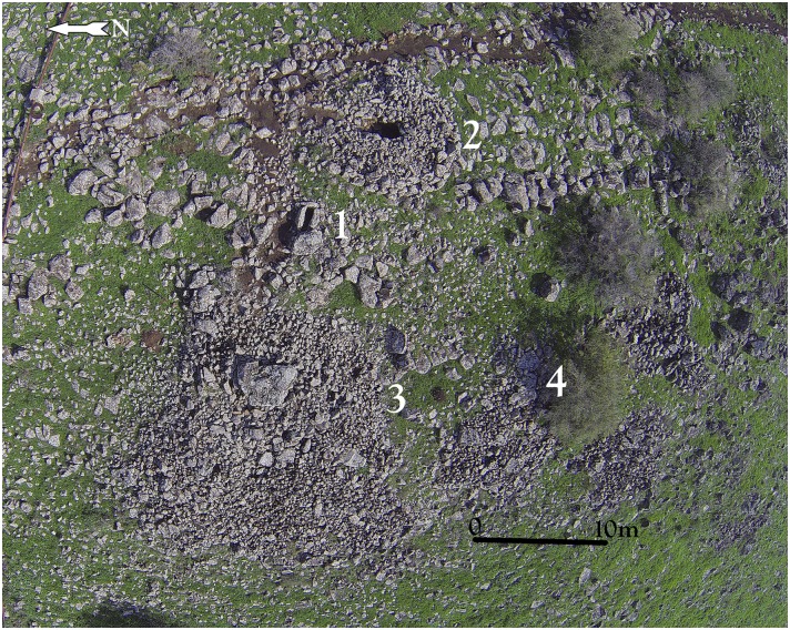
Researchers have classified Levantine dolmens into various types. The Shamir Dolmen Field includes most of these, at times scattered within a few meters of one another. The most distinct type of Shamir dolmen is a circular tumulus, featuring a well-built, surrounding wall constructed from massive stones that bounds a large number of smaller stones forming the tumulus. In the center of the tumulus is a large central chamber entered through a vestibule and covered with a giant capstone. Many of the massive capstones in the Shamir Dolmen Field rise out of their tumulus, most likely designed by the dolmen builders as a prominent landmark, visible even today. While this is the most prominent dolmen type of the Shamir Dolmen Field, other types are found as well. Six of the seven dolmens excavated previously at the Shamir Dolmen Field belong to the smaller type (except for a single, very large dolmen excavated by Bahat). Our study area, marking only c. 50 square meters, contained four different dolmen types next to each other. Hundreds of dolmens are scattered in the Shamir Dolmen Field, yet one dolmen stands out, even among the giants. The largest of the Shamir dolmens and, to our knowledge, one of the largest dolmens ever reported from the Levant, is Dolmen 3.

The architecture of Dolmen 3 is that of the circular tumulus described above but is unique in its size. The Dolmen 3 tumulus, built around a central chamber (3a), is 20 meters in diameter. The total weight of the basalt stones used is estimated at ca. 400 tons. The giant tumulus of Dolmen 3 was built on a slope slanting steeply toward the west. The lower, western part of the tumulus partially collapsed, making it possible to identify two distinct construction stages. The first stage, marked by a circular line of giant boulders, can be observed at approximately half the diameter of the tumulus toward the west. At this line, two smaller sub-chambers (3b and 3c) were built into the corners of the tumulus. In the second stage, additional boulders and stones were piled to the west to enlarge the tumulus to its final dimensions and current state. As in stage one, two additional sub-chambers (3d and 3e) were constructed at the southwest and northwest corners of the tumulus. It is unknown how much time, if any, transpired between the two construction stages. The four sub-chambers built into the Dolmen 3 tumulus are each medium-sized (c. 1 X 3 meters) and elongated, and covered by one to three massive basalt capstones.

In the upper part of the Dolmen 3 tumulus is the central chamber 3a. The chamber is rectangular, 3 meters long by 2 meters wide, and the ceiling is ca. 1.7 meters above the present day surface prior to excavation. To the north is a corridor entrance, roofed by elongated massive basalt slabs and blocked by stones. The present-day entrance to the dolmen is through a gap created by a fallen standing stone at the northwest corner of the chamber. Topping the central chamber of Dolmen 3 is a single giant, basalt capstone. The stone, irregular in shape, measures over 4 meters in length, 3.5 meters in width and more than 1.2 meters in thickness, with an estimated weight of over 50 tons. This is one of the largest stones reported to have been used in the construction of a dolmen in the Levant. On the southeast corner of the central chamber ceiling, the panel of engraved rock art was discovered. For comparison, at Tell er-Ras in Jordan, the average limestone roof-stone measures 300 x 250 x 50 cm, weighing, therefore, approximately 4 tons, while the average side-stone weighs 1.5 tons. Bahat estimated the weight of the capstone of the dolmen he excavated to be c. 30 tons. Dolmen 3 is, therefore, a unique, monumental, multi-chambered dolmen, with a hierarchical structure: a central chamber roofed by a gigantic engraved capstone and surrounded by a giant tumulus into which at least 4 additional sub-chambers were built. This is the first reported complex “multi-dolmen” in the Levant. It should be noted that the adjacent Dolmen 4 is of the same multi-dolmen type.

Excavation of the central chamber of Dolmen 3 focused on the southwest quarter of the chamber. The objective was to expose the stratigraphic sequence of the accumulation while leaving a significant section of the sediments available for future investigation. It is now possible to reconstruct the stratigraphic sequence of the dolmen and its implications for the post-depositional accumulation processes, construction, and burial praxis of this megalithic structure.
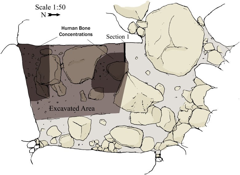
The stratigraphic sequence of the dolmen 3a chamber comprises the following layers, from top to bottom: The pre-excavation surface of the chamber was comprised of large stones and slabs (>50cm), many of which were scattered alongside the chamber walls. The stones and slabs were either part of the original dolmen floor or, more likely, collapsed inward. In either case, it is impossible to discern the form of the original surface. It should be noted that excavation to date of all other chambers in the Shamir Dolmen Field and in other fields in the Golan always exposed a basalt slab paved floor.
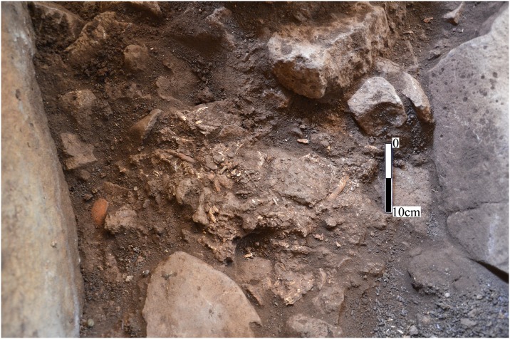
Immediately below the surface was a layer of dark soil containing numerous heavily fragmented bones and ceramics.

The archaeological horizon of chamber 3a is very close to the surface. Below the archaeological layer is 30 to 40 cm of archaeologically sterile sediment that filled the chamber before the archaeological remains were laid. The following interpretation for this stratigraphy can be suggested: The builders erected the gigantic side-wall slabs, possibly by first digging into the surface of the slope. In the next stage, before placing the giant capstone on top of the chamber walls, the builders filled the chamber with sediment and stones to prevent it from collapsing when placing the 50 ton capstone. Once the capstone was in place, the builders removed a portion of the fill, leaving some 40 cm of sediment without levelling the surface. The human bones and ceramics grave goods were laid directly onto this uneven surface. In addition, sections of the chamber surface were covered by large slabs with only sterile sediments beneath them. It is impossible to say whether the burials were originally covered by stone slabs.

Human bones, including fragments of long bones, skull bones, and teeth, were found in many of the Golan dolmens. However, the poor preservation of the bones (and of the ceramic sherds) due to moist conditions inside the chambers hampered further research. In many cases bones were pushed aside to make room for later burials indicating, as Epstein noted, that the burials were secondary. Epstein suggested that perhaps not all skeletal bones were reburied in the dolmens. Epstein assigned the post IB (MBI in Epstein’s terminology) finds from many of the Golan dolmens to reuse of the dolmens for burial in later periods.
Since their first discovery over 100 years ago, the chronology of the Levantine dolmens has been in debate. These dolmens are large structures, dominating the landscape, and many were either robbed or reused over the majority of their existence. The combination of heavily disturbed depositional history and poor preservation conditions resulted in the absence of reliable datable material from most dolmens excavated in the region. To date, not a single radiometric date was obtained from a Levantine dolmen.
Levantine dolmens have been assigned chronologically to the Pre-Pottery Neolithic (based on the absence of ceramics), the Chalcolithic, all stages of the Bronze Age and to later periods.
All evidence suggests that east of the Jordan Rift Valley, south of the Yarmuk River, burial in dolmens was a common practice during the Early Bronze Age I (4th millennium BC). These new discoveries support the suggestion that the dolmens of the Golan (north of the Yarmuk River) and Galilee should be distinguished from the dolmens east of the Southern Jordan Rift Valley. The Golan dolmens differ from the southern dolmens in the type of rock used for their construction (basalt vs limestone and sandstone), in size (they are typically much larger), in their design (typically passage tombs covered by a constructed tumulus), building technology (unworked stones), and in their chronology. It seems that the Golan and Galilee dolmens find their cultural roots in the north, in the megalithic traditions of Syria and Anatolia. In all of the many dolmens excavated and surveyed in the Golan and its escarpments, the earliest material unearthed clearly belongs to the Intermediate Bronze Age.
All finds to date from the Shamir Dolmen Field support IB chronology and Dolmen 3 is no exception. Similar to all other dolmens excavated in the Levant, dating is based upon the chamber finds, particularly on ceramic evidence.

The ceiling panel (on the Dolmen 3 central chamber), located at the southeast quarter of the chamber ceiling, includes fourteen clearly identified schematic, engraved elements. The forms represent variations on a single motif, comprising a vertical line with a downturned arc attached to its upper part. The length of the central line differs between elements as does the curvature of the arc. The average size of the elements is about 25 cm. The alignment of each individual element is slightly different, creating an arced path of movement across the chamber ceiling, from northeast to southwest. The forms were made by pecking into the face of the basalt rock. The inner surface of the engraved lines is relatively uniform and could have been made by chisel or hammer/axe either of metal (bronze) or stone such as flint.

Similar to megalithic rock art worldwide, the Shamir line and arc motif is abstract in nature. While arcs are commonly depicted in this context, no exact parallel exists for the Shamir vertical line and arc composition.
The meaning of rock art and its function within the megalithic context remains ambiguous and the engravings on the Shamir capstone are equally challenging to interpret.
Dating rock art is difficult. It is even more complicated when the art is out of context as in the case of the vast majority of rock art found in the Southern Levant deserts. The Shamir panel is unique as it is found in an archaeological context, next to a burial dated to the IB. The engravings can be associated with the actual building of the dolmen and the burial in it for the following reasons:
a) the engraved forms are similar in patination to the untouched rock face;
b) the hidden location of the panel inside the blocked chamber refutes the possibility that it is a territorial or other land marker or declarative art;
c) the location of the panel above the burial supports a symbolic meaning for the engravings; and
d) the motif has no known parallel in Levantine rock art and cannot be attributed to a later period.
These findings support the in situ nature of the rock art panel, placing it in the context of the construction of the dolmen in which it was engraved. As such, it is one of the rare cases in which early Levantine rock art can be dated and explored, in this instance, in the context of a complex megalithic burial site.
The Shamir Dolmen Field is evidence of a hierarchical, complex society with well-defined burial customs and monumental architectural design, requiring a great deal of human labor and effort. Complex burial customs, a hierarchical burial system, and symbolic rock art all suggest a much more complex socio-economic system in the Hula Valley Basin than thought possible in the Levantine Intermediate Bronze.
(Source: “Monumental megalithic burial and rock art tell a new story about the Levant Intermediate Bronze “Dark Ages””, by Gonen Sharon et al., 2017)

Research-Selection for NovoScriptorium: Philaretus Homerides
