
The oral and written tradition of Greek mythology*, dealing with natural catastrophes, explained in a spiritual and mystic way, is mind-blowing, since they show already a great knowledge about prehistoric times. Archaeological research has elucidated in great detail the Mediterranean history since Archaic times. Prehistoric and in particular the transition from Palaeolithic through Mesolithic to Neolithic periods still remain with many unexplained gaps and questions. What was the reason for the lack of people during the Bølling-Allerød oscillation warming and the subsequent strong and sharp onset of the cooling effect of the Younger Dryas, together with the disappearance of large Pleistocene mammals like the woolly mammoth, starting at 12,800 years before present? No geological and archaeological findings that could explain realistically this problem exist in Greece.
[NovoScriptorium: We suggest a read of our relevant* articles (1, 2, 3, 4, 5, 6, 7, 8)]

Here is tested the provocative hypothesis that the Pagasitic Gulf was formed by a gigantic airburst of an asteroid or a comet, as part of the 12,800 years cosmic shower over the northern hemisphere, followed by fires and floods, which triggered the Younger Dryas. It should give possible answers about the missing links of the geological and historical evolution in the classical region of “Hellas” and wider surrounding areas during the critical time from Late Pleistocene to Early Holocene, e.g. the enigmatic gap to the rapid cooling and missing of a transition of anthropogenic and faunistic remains.
The puzzle to achieve a logic sequence of events in the hypothesis is based on as much available scientific data, that is geological, petrological, chemical, isotopic, geophysical, oceanographic and climatic data, as well as on archaeological evidence.
The Younger Dryas in Europe
The rapid cooling of the Younger Dryas at 12,800 ± 150 years ago (Kinzie et al. 2017) is one of the most abrupt climate changes observed in Northern Hemisphere paleoclimatic records: δ18O composition in Greenland ice cores, varve microfacies in a volcanic maar lake, speleothems and mapping late-glacial and Holocene European pollen (Hartz and Milthers 1901; Brauer et al. 1999, 2008; Carlson 2013; Sadori et. al. 2016; Brewer et al. 2017).
The Younger Dryas late glacial cooling period following the Pleistocene ice ages with a gap of a warm, 2000 years lasting period in northern Europe is regarded today as a crucial time span, as it appears to be a bottle-neck in the development of mankind, the mysterious disappearance of early hunter and gatherer, which was followed by an explosive growth of agricultural settlements during Mesolithic period (Cummings et al. 2014), according to the north Mediterranean chronology, respectively to Neolithic period, according to the southeast Mediterranean chronology. All over Europe and even in its southern parts the Younger Dryas showed strongly cold and arid conditions with an annual decrease of approx. 5-15 degrees Celsius, depending on altitudes (Tzedakis et al. 2004a and b; Carlson 2013; Seddon et al. 2015; Sadori et al. 2016; Benjamin et al. 2017).
During the cooling, vast areas of wild wheat and barley had allowed the first nomadic gathering-hunters in the Thessalian plains, as well as in the Middle East to establish permanent base camps. With the exception of a few caves, e.g. the Theopetra Cave in Thessaly (Facorellis et al. 2001; Kyparissi-Apostolika 2015), the Sarakenos Cave in Boeotia (Sampson 2008a), very little information exists from Mesolithic time from the Greek mainland. In contrast, Mesolithic sites are found in several caves close to the seaside (e.g. Franchti and Gioura), and on several Aegean islands (Ikaria, Milos, Naxos, Kythnos). Geological and bathymetric reconstructions indicate that still portions of the Aegean Sea, e.g. the Cycladic islands, have been subaerially exposed for most of the Late Pleistocene and acted as biogeographical land bridges (Kapsimalis et al. 2009; Lykousis 2009; Tourlokis and Karkanas 2012; Sakellariou and Galanidou 2015; Papoulia 2016).
[NovoScriptorium: We firmly suggest a read of our articles on the Mesolithic and Neolithic eras (1, 2, 3, 4, 5, 6, 7, 8) in the Aegean/Greek peninsula]
The difficult climate conditions following the Younger Dryas cooling forced the earliest Mesolithic gathering-hunters to come together and work out first ways of maintaining the crops, through watering and selective breeding. Thus, farming began, allowing the rise of the first reinforced Magoula settlements. The hunted wildlife during the Late Pleistocene in the steppe of the Thessalian plains were similar to those of Eurasia and North America, which included large mammals such as the woolly mammoths, stephanorhinus, giant elk, the straight-tusked elephant and others. Fossils of this typical megafauna have been found in Peneios‟ lower terrace (NW of Larissa) and been dated to 45–30 ka (Demitrack 1986; Runnels and van Andel 1993a andb; Athanassiou 2011; Runnels 2014). Similar slow changes followed during the cold and dry Younger Dryas climate, such as the transition from woodland to step on the northern hemisphere, which forced the survived inhabitants to start farming instead hunting and gathering. In the Aegean realm sea-level rise changed the landscape progressively, inundated coastal sites and changed fishing and shell fishing grounds. Existing islands disappeared; new islands and straits appeared (Benjamin et al. 2017). The onset of reforestation began around 12.4 ka BP, with different vegetation dynamics and woodland densities in the Greek mainland.
A Meteorite Impact as Trigger of the Onset of the Younger Dryas
An outstanding but controversial* hypothesis on the origin of the Younger Dryas appeared in 2007. According to Firestone et al. (2007), a high-energy impact burst destabilized and melted parts of the Laurentide Ice Shield and consequently, flooded across large parts of North America and drained into the North Atlantic. Such a huge fresh water pulse might have caused a slowdown or complete shutdown of the North Atlantic Conveyor, which carries tropical warm water northwards and thus triggered the onset of the Younger Dryas (Broecker 2006), a rapid cooling with a temperature drop as much as 15oC at the northern hemisphere. A sea-level change definitely has been recorded in many sedimentary sequences at this time period all over the world and in particular in the Mediterranean, as mentioned before by Sakellariou and Galanidou 2015 and Papoulia 2016.
[NovoScriptorium: We suggest a read of our relative post on this*. Evidence shows that there is nothing ‘controversial’ about it]
The Younger Dryas onset impact was likely the result of multiple impacts of small sized asteroids, maybe in the order of up to kilometer size projectiles. Up to now, there are three enigmatic circular objects in the northeast of the United States and Canada, which are possibly impact craters formed by fragments of a large object that hit the Laurentide Ice Shield or exploded in the atmosphere:
1) The Charity Shoal, a circular one-kilometer in diameter and 19 m deep basin in Lake Ontario (Holcombe et al. 2001);
2) The Bloody Creek Crater in southwestern Nova Scotia, a half-kilometer diameter and 10 m deep structure (Spooner et al. 2009);
3) The four kilometer diameter between 40 and 185 m depth Corossol Crater in the Gulf of St. Lawrence, Canada (Higgins et al. 2011).
Except of the Charity Shoal structure, the Bloody Creek and the Corossol Crater were proven to have originated by meteoritic impact due to finding of high-pressure minerals and impact fabrics. In addition, recent geomorphological analysis of the Carolina Bays (US Atlantic coastal plain), using Google Earth images in combination with LiDAR data and testing with an experimental model, demonstrated their plausible impact crater origin formed on ground liquefied by the shock waves of secondary impacts of glacier ice bouldersejected by an extraterrestrial impact on the Laurentide Ice.
A large impact crater has been found beneath the Hiawatha Glacier in northwest Greenland (Kjær et al. 2018). The age of the 31-kilometer-wide and up to 1000m deep crater has been estimated according heavily disturbed Pleistocene ice overlying Precambrian basement, as well as to the continuous and conformable Holocene ice sheet cover as close to 13,000 years BP. The authors imply that such a large crater must have been formed by an impact of an approx. 1km iron asteroid.
The worldwide effect of a meteorite shower covering a strewn field over the Northern Hemisphere, estimating more than 50 million square kilometers, may have triggered the onset of the Younger Dryas and causing wildfires everywhere, as well as rapid cooling (Wittke et al. 2013; Wu et al. 2013; Kennett et al. 2015; Kinzie et al. 2014). As result of extensive atmospheric soot and dust, the warminterstadial “Bølling-Allerød”period turned rapidly into the «impact winter» of the Younger Dryas sustained by the break off of major ice masses from the Laurentian ice shield and blocking warm Atlantic currents toward north. Wolbach et al. (2018a and b) reinvestigated all available evidence of such hypothetical cataclysmic scenario compiling quantitative analyses of charcoal and soot records from 152 lakes, marine drill-cores and terrestrial sequences that testify large wildfires and biomass burning. Napier and Cube (1997) already suggested that the Earth is in a state of “coherent catastrophism” since 20 to 30 thousand years ago. A large progenitor of the Enke comet with an estimated diameter of more than 100 km might have entered the solar system orbiting the Sun. Fragmentation due to an eccentric movement around the sun generated an orbital ring of debris intersecting the Earth‟s path, which resulted in meteorite showers, the “Southern and Northern Taurids”, known since historical times. A several kilometer large fragment from the Taurid stream, entering the Earth‟s atmosphere, most probably was disintegrated with multiple airbursts and impacted with high energy on the Earth‟s surface all over the Northern Hemisphere (Napier 2010; Napier et al. 2015).
Geological evidence of such a catastrophic event is demonstrated by the dispersed glassy silicate and carbon spherules and nanodiamonds in the order of 10 million tons containing micron sized zircons and rutile, high-temperature melted glass, a wide spread platinum anomaly and occurrence of nanodiamonds in eleven archaeological sites across North America (Bunch et al. 2012; Moore et al. 2017) and in the Greenland ice (Kennett et al. 2009; Kurbatov et al. 2010).
A “black mat horizon” containing nanodiamond polymorphs mixed with “glass-like” carbon microspherules dated 12,900 years ago has also be recognized in North America (Kennett et al. 2015). The instant “megafauna or mammoth extinction” seem to have commenced also at this time maker, but continued certainly over the entire Younger Dryas period, which ended 11,703 ± 4 BP (Holliday et al. 2014; review in Rasmussen et al. 2014). Convincing evidence of a large impact that might have been responsible for the onset cooling of the Younger Dryas has been found in Greenland ice core dust (GISP2) associated with a large Pt anomaly spanning over 21 years (12,836-12,815 BP, Wolbach et al. 2018a), which is interpreted as result of a large Ir-poor iron meteorite shower (Petaev et al. 2013).
Benchmarks for the existence of the cosmic cataclysm in Europe and Asia at 12,800 years BP are the archaeological findings of the settlement Abu Hureya in the Euphrates valleys. Soil samples contained a high amount of glass spherules of 20-50mm and vesicular, scoria-like objects (SLO)>5.5 mm, which are composed of amorphous SiO2 (lechatelerite) mixed with CaO-rich glass. Moore and Kennett (2013) claimed these features as result of melting underground sediments caused by a high-energy air-burst/impact in the vicinity of Abu Hureyra (northern Syria) at around 12,800 years ago.
Pagasitic Gulf, a Possible Complex Impact Crater
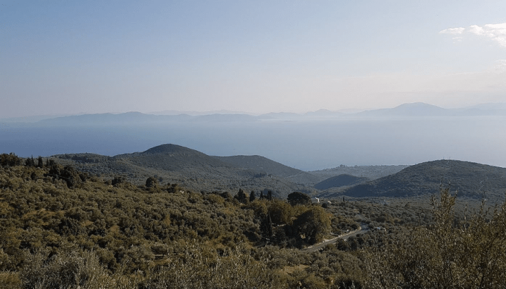
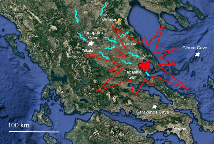
According to the Hellenic myth, Zeus hurled a thunderbolt down to earth from the throne of gods, Mount Olympus, to destroy Phaethon, the son of Helios, and “burnt up all that was upon the earth” (Plato’s Timaeus). Despite the ancient myth, there is always a reality, a kern of truth hidden behind. Not far south from the “site of the divine punishment” lays the Pagasitic Gulf (Pagasitikos Kolpos), an approximate 20 to 25 km large irregular shaped circular shallow gulf that is connected with the Evoic Sea to the south through a 4km wide channel, the Trikeri Strait. The large sickle-shaped Mount Pelion Peninsula separates the gulf from the North Aegean Sea to the West and South. The eastern shores of the gulf are bordered by the foothill extensions of the Orthris Mountains and the conical shaped alluvial plain of Almyros, while the northern shores border the Nea Anchialos mountain range in the western part, and the Volos Bay and plain in the eastern part. The bowl-shaped geometry of the gulf, the inclination of all embankment lithologies towards the gulf and in particular the unusual and unique morphology and structural features that evolved from the 3D Google Earth images, as well as the recognition of abundant regolithic and weakly cemented brittle surfaces along the shores and hill sides, led to the assumption that the bowl-shaped gulf may have been formed by an impact, either by a meteorite or by high-pressures of an air-burst, probably contemporaneous with the Zerelia Twin Lakes (Dietrich et al. 2017). The proof of such large catastrophic event at the beginning of the Holocene would underline the Younger Dryas Impact Hypothesis and help to explain the spatial and temporal distribution of mankind in southeastern Europe, between the Paleolithic, Mesolithic and Early Neolithic.
Bathymetry of Bowl-Type Gulf
According to regional reconstruction, a marine ingression, which led to the manifestation of the Pagasitic Gulf, allows only speculation, but has been estimated as Early Holocene (Van Andel and Perissoratis 2006; Sakellariou and Galanidou 2015). A certain calibration can be made, comparing the oceanographic and sedimentary results in the western basin of the North Evia Gulf (Sakellariou et al. 2007) according to high-resolution sub-bottom profiles and gravity coring.During the last glacial period the water level of the North Evia Gulf was about 90m below the present sea level with lacustrine sediments that were formed during the last glaciation. In addition, this thick sedimentary sequence was covered by a prominent unconformity, which was topped by a thin marine sedimentary sequence. This interpretation leads to a major tectonic movement accompanied with a dramatic rapid uplift of the region, most probably during the Pleistocene/Holocene boundary. We tent to relate this rather rapid feature with a catastrophic event in the Pagasitic environment. In contrast to a rapid process, the region of the Almyros plain and Pagasitic environment seem to have been rather stable besides local earthquake activity along the Almyros and Anchialos fault zones (Caputo and Pavlides 1993; Papazachos and Papazachou 1989). This has also been proven by the stable coastlines of the Pagasitic Gulf (Galanakis et al. 1998), which indicates the absence of any differential uplift between the Aegean Sea level and the surrounding mountain chains since early Holocene time.

Slumping and Landslides
The use of high-resolution and 3D imaging Google Earth reveals another remarkable geomorphological feature. Many mountain slopes around Pagasitic Gulf exhibit a step-like landscape, which can be explained as a result of special feature of a mass wasting collapse structure, e.g. slumping or landslide, which are designated depending upon their size mainly between several tens of meters up kilometer size.
Slumping is a linear to sickle shaped, mostly planar scarp that usually parallels an elongate ridge and faces uphill. A typical characteristic feature is the valley behind the scarp, which has the morphology of an asymmetric neck, a neck-type valley with a steep wall downhill and a gentle wall uphill. In general, this morphological feature may on first examination appear to be young tectonic features and has been used to interpret its origin due to earthquakes. In high-altitude glaciated mountainous areas, slumping has also been recognized as post-glacial features.
Generally, slumping or a landslide occurs as movements of large masses of earth and rocks down a hill or a mountainside. Little or no flowage of the materials starts on a given slope until heavy rain and resultant lubrication by the same rainwater facilitate the movement of the materials, causing slumping to occur. Slumping on local scales and landslides on larger scales can also start spontaneously by a shock, such as an earthquake or as slow movements over timespans of several years. Requirements are more or less planar unconformities between lithological units and preexisting fractures and faults, which provide circulation of water. In addition, often lithologies with physical properties predestined for alteration and argillitization turn into lubricant horizons.
Listric Faults and Collapse Structures
In the case of the Pelion situation as well as in other, the Pagasitic Gulf surrounding mountainous areas, the intensive pre-Neogene Alpine thrust sheet tectonics of the Pelagonian nappes with the predominant content of highly tectonised overthrust horizons, consisting of mylonitized slates, phyllites, schists and serpentinites facilitate the landsliding and slumping capability.
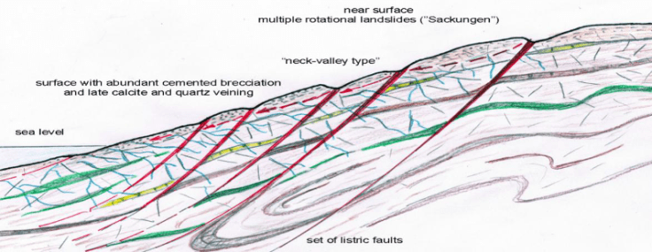
Surface ruptures, which crop out at the surface as more or less vertical steep scarps seem to have turned into listric faults, starting with a steep inclination surface and rotating to a shallower dip with increased depth. The dip may flatten into a sub-horizontal décollement, resulting in a horizontal displacement.
These structures have been recognized in many places in the mountainous surroundings of the Pagasitic Gulf with general inclinations of the lithologies towards the gulf. Because of the consistency, we interpret them as collapse structures related to a contemporaneous event.
3D Fault Pattern Observation
Detailed observation using Google maps and enlarged 3D Google Earth images reveal many faults in the coastal and mountainous surroundings of the Pagasitic Gulf, which cannot be recognized in the conventional way from the surface.

These are sets of normal steep faults causing narrow gorges and valleys and run more or less perpendicular to the directions of the landslide morphology). Of course, the larger normal and strike-slip faults systems that was recognized as pre-Holocene of age and due to historical earthquake activity is apparent and marked, too. In the Pelion Mountain range, the Trikeri Peninsula and the Kokkinovrachos range, the E-W and different NE-SW fault directions are dominant, whereas in the Nea Anchialos – Cape Agistri Range a NW-SE fault pattern is evident. However, it is difficult for most of them to establish a recent reactivation. In general, the sum of all fault-sets leads to an impression of a certain radial appearance pointing towards the gulf.
Surficial Cataclastic and Brittle Deformation
Evidence of a meteoric impact is normally given by pressure and temperature effects on the underground of the impact site, e.g. on rocks and soil inside the impact crater, the distal environment and the occurrence shock-infected or molten ejecta. In the case of a possible impact forming the Pagasitic Gulf, no material from sea floor is available. Only the distal environment has remained for investigation.
In fact, along the embankments and under the young Quaternary surface fracturing, brecciation, cataclastic and brittle deformation is present in different lithologies along the shores. A large variety of breccia occur, in most cases monomict breccia, clast and matrix supported with clasts from millimeter to decimeter size. However, typical impact melt breccia (matrix-melt breccia) and suevite (breccia with glass, crystal and lithic fragments), as well as distal ejecta layers containing spherules have not been recognized.

[Figure: Selected locations of fractionated and brecciated surface along the cost of the Pagasitic Gulf: a) Fractured gneiss quarry below hill of Amphanae with heavily broken surface; b)between Kritharia and Stavros distorted and brecciated crystalline limestones and schists, partly filled with reddish Pleistocene red beds and hydrothermal deposits, dipping towards sea; c) Roadcut along Cape Ghoritsa showing different types of fracturing the Triassic marbles from simple fracturing to cataclastic monomict breccia and in part pulverization; d) Cape Ghoritsa, the surface exhibits consistently fine to moderate monomict brecciation and showing an open conjugate network of straight fractures; e) Intensive fracturing in small quarry below the village of Servanates (above Kato Lechonia); f) South of Paou beach (southwest of Arghalasti). The coastal outcrops of monomict breccia are representative for many of their kind along the western shores between the villages of Afissos and Milina. They are most significant in platy crystalline limestones. The surface layers are chaotically brecciated and cut by irregular breccia channels cemented with matrix calcite and oxides; g) coastal outcrops at Milina, the breccia is topping broken layers of platy limestone; h) roadcut west of Panaghia chapel (Trikeri Bay) with a unique deformational geomorphological feature. The brecciated Quaternary surface seems to fill highly deformed depression in pulverized Triassic marbles.]
In general, all lithologies dip towards the gulf. Slumping appears using the 3D observation in the Google Earth maps. Most of the deformation, gentle folding and schistosity can be assigned to pre-Quaternary orogenic processes. Post-deformational features are steep normal down faulting parallel to the coastline (Anchialos Fault Zone) as well as minor perpendicular fault systems. The gneisses are deeply fractured in several areas, the surface in addition chattered. Between Kritharia and Stavros crystalline limestones and schists are distorted and brecciated, partly filled with reddish Pleistocene red beds and hydrothermal deposits, dipping towards sea.
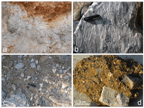
[Figure: Special deformation and brecciation characteristics; a) highly deformed depression in pulverized Triassic marbles filled by brecciated Quaternary surface. This effect cannot be explained by any recent dynamite blasting, due to the undisturbed dense vegetation above. The only interpretation remains at the moment due to an impact affect; b) weathered surfaces of crystalline platy limestones with narrow divergent ridges (striation) Old Trikeri Island and close to the port; c) polymict matrix supported breccia at Lefokastro; d) close up polymict matrix supported breccia with components of dark crystalline limestone and white marble (Servates above Lechonia).]
A similar situation of intense fracturing is evident along the shore of Cape Ghoritsa for almost two kilometers between Volos and the cement factory of Asteria/Agria. Outcrops are best exposed in the cliffs and in the main road cut. In all cases, especially the surface of the marbles is highly fractured and exhibit strong striation. These features are repeated at the coastal cliffs of Rivera beach west of Kato Ghadzea. There, the monomict breccias are filled with reddish Pleistocene red beds and hydrothermal deposits, dipping towards sea.
Tectonic and Planer Deformation in Quartz and Calcite
Sampling was concentrated on quartz veins in all lithologies along the shores and hill sites around the Pagasitic Gulf, thus in the distal environment of the possible crater formed by an impact blast. The goal was to detect impact related shock metamorphic deformation. In order to discriminate post-orogenic shock-induced cataclastic fabrics, orogenic tectonic fabrics had to be recognized and extracted. In most cases, multi deformational phases are present overprinting each other, which obliterates a proper identification.
The Impact Hypothesis
In the conventional way, the Pagasitic Gulf may be explained as a simple Pleistocene and Holocene tectonic depression, an extension of the AlmyrosBasin and intersecting the NW-SE Pelion Fault System as result of continuous uplift of the Olympus-Ossa-Pelion mountain range since Early Miocene time. However, a subsidence of the gulf can be ruled out because of the lack of shallow terraces. The Quaternary morphotectonic configuration of its mountainous surroundings with their lithologies dipping towards the gulf and style of brittle and cataclastic deformation in the surficial rock formations require a new approach of geological and geophysical interpretation. Within the framework of the above concept, the possibility of the impact hypothesis is analytically introduced in the following, where among other issues, the modelling of the existent geophysical data seems to be consistent to an impact case scenario.
Asteroid Impact or Comet Airburst
The irregular circular embayed shape of the coast lines as well as the size and the bowl-type bathymetry of the Pagasitic Gulf suggest for their formation an assumption of a complex crater structure as a result of an extraterrestrial impact event. All newly observed uncommon structural criteria (slumping, landslides) and special deformational phenomena (brecciation and planar microfractures) favor an origin of a blast pressure pattern as result of a possible impact of a cosmic body asteroid/meteorite impact or comet airburst.
Impact Modeling
In order to test the observed structural criteria of the lithologies surrounding the Pagasitic Gulf: slumping, landslides and brecciation as well as the low-pressure impact fabrics in the limestones and siliceous rocks, we used the “Web-based computer program for calculating the regional environmental consequences of a meteoroid impact on Earth” (Collins et al. 2005). The results should give a first approximation about the impact crater size and depth, a possible discrimination about the character of the impactor, either an iron or stone meteorite or a porous ice comet as well as about the nature of impact as a single simple event or a complex airburst. Basic input requirements are the impactor diameter, impactor density, impact velocity before atmospheric entry, impact angle, the distance from the impact at which the environmental effects are to be calculated, and the target type (sedimentary rock, crystalline rock, or a water layer above rock). Three general impactor types were chosen for modeling: an iron asteroid with the general density of 7500kg/m3, a stone meteoroid with the general density of 3000kg/cm3 and a porous dust and ice comet with a general density of 1500kg/m3.
A more realistic cosmic impact scenario that could fit all observed ground parameters of the Pagasitic Gulf and its surroundings evolves from the model calculation using a porous dust and ice comet of 1km dimension with a density of 1500kg/m3 and an atmospheric impact velocity of 50km/s. The breakup of such a projectile starts already at 89.7 km with a very high impact energy of 9.52 x 10²⁰ Joules = 2.28 x 10⁵ Mega Tons TNT. Due to its fragile constitution, the large dust and ice comet should fragmentate within seconds as multiple airbursts instead of reaching the ground. However, the very high impact energy could create a complex transient crater with a diameter of 13.47km with a transient depth of 4.74km, which turn into a final crater of 18.9km with 717m depth. The model calculation of both, size and depth of the crater can only be first approximations, since the model deals with a real impact of the target by the projectile.
The environmental effects are catastrophic on a large regional scale: The seismic shaking reaches a magnitude of M=8.2 on the Richter scale, the hot air blast of the bursts a peak overpressure of 242 MPa blowing down all trees over more than 100km distance with half of supersonic speed and causing wild fires everywhere.
Despite such an environmental cataclysm, the airburst may have devastated a vast area by an air blast and thermal radiation but did not affect the crystalline underground and Neogene cover in terms high-pressure and temperature to cause evaporation and melting as well as impact deformational features. Considering the assumption of a multiple airburst starting at high-altitude, pressures emitted from the air blasts with a calculated peak overpressure of approx. 0.2 GPa could have over deepened the entire shallow Pleistocene basins Pagasitikos and Almyros, as well as the plains of southern Pelion, finally reaching the morphological impact-crater shape of the Pagasitic Gulf.
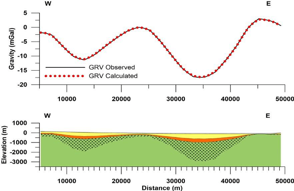
An attempt was made to investigate whether the observed gravity anomaly over the wider area of Pagasitic Gulf could account for such a model of the upper crust, considering the characteristics of the top upper layers being suffered by a case of an air-burst. The Gravity Anomaly Map of Greece (Lagios et al. 1995) was primarily considered and used in the present impact hypothesis for the broader area o Pagasitic Gulf. The gravity data of the enriched Gravity Data Bank of Greece (Lagios et al. 1996) were used and reduced to gravity anomaly values. Such kind of model is presented along Profile E-W (Figure below) that was extended on both sides over the gulf. A borehole at the western part of the area on land was used as control of the sedimentary sequence in the above model. It appears that the outcome of the above model relating to the final depth (800m) and diameter crater (20km) dimensions is consistent with the results of the impact program outlined above (717 m and 18.9 km, respectively).
Fires All Over, Pagasitic Gulf Airburst Model
Structural and sedimentological criteria in the region of the Pagasitic Gulf point to a major rapid change of the environment in central Greece between Late Pleistocene and Early Holocene and may coincide with the climate change at the onset of the Younger Dryas in the northern hemisphere at around 12,800 ± 150 years ago (Kinzie et al. 2014). We are tempted to relate the dramatic environmental cataclysm with the hypothesis of a collision of a large comet or asteroidof the inner solar system with the Earth disintegrating over the northern hemisphere at around 12,800 B.P., and consequently leading to countless airbursts and impacts with a wide spread of wildfires and biomass burning, consuming about 10 million km2 or about 9% of the Earth‟s terrestrial biomass (Wolbach et al. (2018 a and b). Such an atmospheric entry may have started over North America and the Laurentide Ice Shield, reaching also Fennoscandia and northern Europe.
The irregular circular embayed shape of the coast lines, as well as the bowl-type bathymetry of the Pagasitic Gulf, suggest for their formation an interpretation of a major airburst creating a giga air blast that started entering the atmosphere already at high altitude, similar but on a mega-scale compared to the inferred situation of the Tunguska event (Shuvalov and Trubetskaya 2007), rather than an impact of a solid meteorite of large dimension, as it is also indicated by the geophysical modelling.
The hypothetical cosmic impact scenario that could fit all observed ground parameters of the Pagasitic Gulf and its surroundings evolves from the model calculation using a porous dust and ice comet of 1km dimension with a density of 1500kg/m3, an atmospheric impact velocity of 50km/s and entrance angle of 45 degrees. The breakup of such a projectile starts already at 89.7 km with a very high impact energy of 9.52 x 10²⁰ Joules = 2.28 x 10⁵ Mega Tons TNT. Due to its fragile constitution, the large dust and ice comet should fragmentate within seconds as multiple airbursts instead of reaching the ground. The latter could explain the irregular and slightly oblong shape of the gulf and the occurrence of several bays due to multiple small impact craters formed at the same time.However, the very high impact energy could create a main complex transient crater with a diameter of 13.47 km and transient depth of 4.74km, which turn into a final crater of 18.9 km with 717m depth (Figure below), consistent to the present-day gulf dimensions and geophysical modelling.

The environmental effects according to such a giant airburst model are catastrophic on a large regional scale: The seismic shaking reaches a magnitude of 8.2 on the Richter scale, the hot air blast of the bursts produces a peak overpressure of 242 MPa, blowing down all trees over more than 100 km distance with half of supersonic speed and causing wild fires everywhere (Figure below). The airburst may not have devastated only a vast area by the air-blast and thermal radiation (modeling in Shuvalov et al. 2014), but also may have caused heavy fractionation and brecciation in the surficial rigid lithologies in the surroundings of the Pagasitic Gulf.
Such a cataclysmic airburst scenario must have had a dramatic impact to the entire region in central Greece. Surface pressure waves, lightning and thunderstorms deforested and burned a vast area with wild fires, extinguishing all terrestrial life. This must have affected almost the entire Pleistocene human population of hunters and gatherer, living in small fell tents, brushwood huts, and mammoth-bone dwellings. The assumption is based on the fact that a large fauna and human settlements must have existed in the plains and along the river banks and shores of the shallow lakes (flood plains) formed during the last warm Bølling-Allerød period between 14,700 and 12,800 years BP.
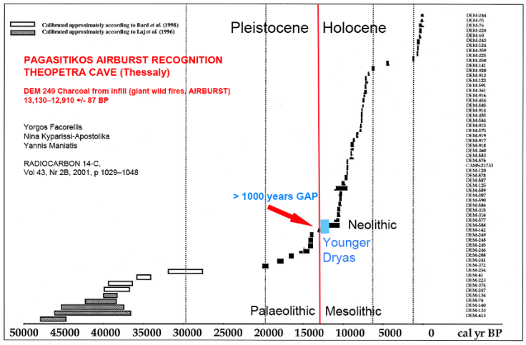
It is possible that only small groups of cavemen survived the catastrophe, e.g. in the Gioura Cave in the North Aegean Sea (Sampson 2008b). Remnants of catastrophic wildfires and flooding in the wider environment of Pagasitic Gulf are evident so far only in a few locations, i.e. in caves, acting as geological traps of the past. So far, the best location could be found in the Theopetra Cave on the northwestern end of the large Thessalian plain, ca. 100km away from Pagasitic Gulf.
The charcoal infill between chaotic silt-rich upper Mesolithic sediments (Figures below)
yielded an age gap occurred between around 13,000 cal. BP (DEM-249) and 11,200 cal. BP (DEM-142), recorded by Facorellis et al. (2001 and 2013) (Figure below).
The complex matter of sedimentation, indicating the existence of large fires and accompanied chaotic flooding could well be interpreted as the effect of the cataclysmic airburst and blast at Pagasitikos.The almost entire absence of bone residues in the Paleolithic embankments in all central area caves has been explained by a transformation of bone apatite into authigenic complex phosphate minerals, calcite and amorphous silicate by burning, water influx and diagenesis (Karkanas and Weiner 2000; Karkanas et al. 2000). The diagenetic formation of silt and clay, filled in through channels of invasive waters could have been a combination of the giant air-blast dust and subsequent strong flooding.
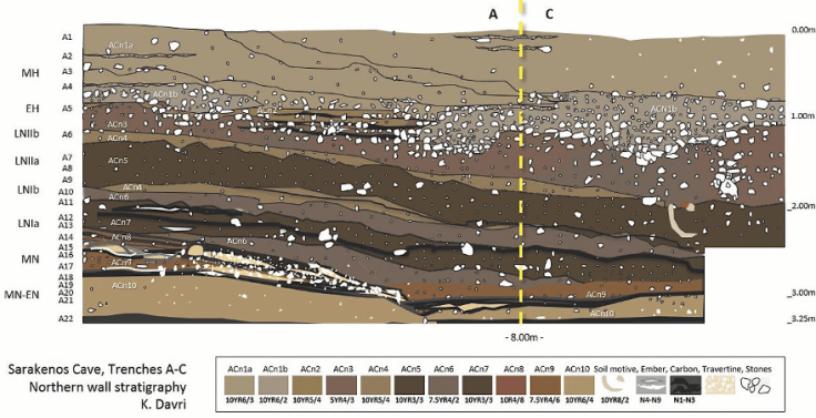
The lowest part of the embankments in the Sarakenos Cave in Boeotia (Central Greece), about 100km south of the Pagasitic Gulf, shows continuous carbon layers (Figure above), which could represent relict sedimentary ashes (soot) of large wildfires, most probably related to the proposed Pagasitikos airburst and blast towards south. The deepest carbon horizons fit with Pleistocene/Holocene boundary (Sampson 2008a; Sampson 2014), since small charcoal particles gave an age of 12,345+/-70 years cal. BP. A fine-grained sedimentary layer containing a “huge concentration of ash and burnings”, but without any artifacts, yielded a long-time gap to overlying charcoal deposits derived from hearth and dated around 9,200 years cal. BP, a transitional age from Mesolithic to Neolithic periods. Thus, the similarities between catastrophic environmental impacts of the Pagasitic airburst in the two prominent caves, which were used for safety and refuge by Paleolithic hunters-gatherer, are obvious.
(Source: “12,800 years ago, Hellas and the World on Fire and Flood”, by Volker Joerg Dietrich et al.)
Research-Selection for NovoScriptorium: Isidoros Aggelos

Reblogged this on Die Goldene Landschaft.
LikeLike
Interesting. But what about that two underwater dome’s near west coast? Existing chevrons do directing in to that direction. Is any research and core drilling on those vary compelling possible impact sites for shacked quartz etc?
LikeLike