; Neanderthals exploited raw materials at altitudes as high as 2,200m")
This post is a summary of official announcements on the very interesting discovery of Neanderthal populations moving at very high altitudes (more than 2,000m) in the Pindus Mountains of Western Macedonia, Greece, and exploiting various raw materials during the Middle Palaeolithic era.
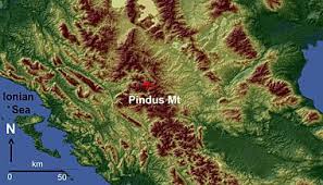
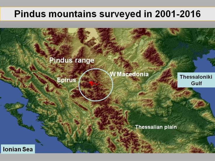
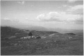
Abstract Surveys and excavations carried out since 2000 in the Pindus Mountains of Western Macedonia (Greece) have led to the discovery of more than 500 Middle Palaeolithic Mousterian sites. They are mainly distributed along the watersheds that surround the high altitude Vlach town of Samarina. The Middle Palaeolithic sites are not the only ones discovered in the area, although they are the most numerous, numbering hundreds of settlements, lithic workshops, chert exploitation and decortication areas as well as isolated chipped stone tools. This paper focuses on the good quality chert outcrops exploited by groups of late Neanderthals during the Middle Palaeolithic period. The region has been inhabited over recent centuries by Vlach transhumant shepherds, representing an ideal case study of highland zone Middle Palaeolithic exploitation in Europe. This is due to its unique characteristics following centuries of transhumance and pastoralism, systematic deforestation, landscape exploitation and the almost total absence of modern settlements.
Discussion The discovery of high altitude Mousterian Levallois sites has radically changed our view of the territories, and hunting strategies exploited by the Middle Palaeolithic hunters of Greece. Regarding Epirus, up until a few years ago these hunters were known mainly from the coastal region and its interior, up to an altitude of ca. 1000 m (Papagianni 2008). Fifteen seasons of systematic and intensive survey and recording in the Pindus mountains have shown that traces of their activity can be recovered also from much higher altitudes, whenever environmental conditions have favoured their preservation, confirming the evidence that mountains never acted as a barrier to movement for the communities of any period of prehistory (see Biagi and Nandris 1994, Stirn 2014).
The spectacular finds from the study region have shown that Middle Palaeolithic hunters undoubtedly moved across wide territories, irrespective of their elevation. Consequently, their economic subsistence strategy was clearly much more integrated than previously suggested (Papagianni 1999), demonstrating the exploitation of different landscapes, and a precise knowledge of their potential resources and territorial characteristics that varied from season to season (Pathou-Matis 2006).
(Source: “The Chert Outcrops of the Pindus Range of Western Macedonia (Greece) and their Middle Palaeolithic Exploitation”, by Paolo Biagi, Renato Nisbet, Ryszard Michniak, Nikos Efstratiou)
Introduction Fifteen years of surveys and excavations carried out in the highland zone of the Pindus range have greatly improved our knowledge of the exploitation of the high altitudes of north-western Greece. Although greater attention has often been paid to the Middle Palaeolithic Levallois sites, workshops and chert outcrops discovered around the Vlah centre of Samarina (Efstratiou et al. 2006, 2011, 2014), the systematic investigations conducted along the watersheds that surround the aforementioned town, and the slopes of the Gurguliu and Bogdhanis Mountains, have led to the discovery of many sites and isolated finds of Late Palaeolithic, Mesolithic, Final Neolithic, Bronze and different historical ages.
This paper aims to illustrate the discovery of a few Late Palaeolithic and Early Mesolithic tools that, given the location of discovery, represent a unique case in the prehistory of this territory of western Macedonia.
Although Late Palaeolithic sites are well attested in neighbouring Epirus (Higgs & Vita-Finzi 1966; Adam 1989; Bailey 1997), nothing was known of their presence at high altitudes in the Pindus range until a few years ago. The Pindus discoveries help interpret the routes followed by Late Palaeolithic and Early Mesolithic hunters. They moved along the Samarina watersheds and across their saddles, midway between the lowlands of western Macedonia, east of the Pindos mountains, and Epirus, in the west, during different periods of the Late Pleistocene and Early Holocene, when the alpine pastures of the Pindus were already deglaciated (Boenzi et al. 1992; Hughes et al. 2006a, 2006b).
Discussion The discovery of Late Palaeolithic and Early Mesolithic tools along watersheds that surround Samarina, and the slope of Mount Vasilitsa, improves our knowledge on the seasonal peopling of the high altitudes of the Pindus Mountains. They show that at the end of the Pleistocene, and the very beginning of the Holocene, groups of late hunter-gatherers moved across the favourable hunting landscapes of the alpine pastures above 1500m.
In contrast with the late Neanderthal bands that systematically exploited the abundant Samarina chert resources (Efstratiou et al. 2011), these hunter-gatherers carried with them good-quality flint nodules to produce their weapons. The presence of end scrapers and other tools, mainly bladelets, might indicate that they also performed other activities connected with hunting. Although the location of the allochthonous flint sources used for making the chipped stone tools recovered around Samarina is at present unknown, good-quality flint outcrops are known in the lowlands surrounding Lakes Ioannina and Kastorià. Future research will explore the exploitation of the above resources between the end of the Pleistocene and the Early Holocene in order to explain the provenance, and the movements of the Late Pleistocene and Early Holocene hunting communities of the Pindus Mountains.
(Source: “Late Palaeolithic and Early Mesolithic finds from the Pindus Mountains of western Macedonia (Greece)”, by Paolo Biagi, Renato Nisbet & Nikos Efstratiou)
Abstract The surveys carried out since 2002 in the Northern Pindus of Western Macedonia (Greece), have led to the discovery of an impressive number of sites, lithic scatters, findspots and isolated artefacts, techno-typologically attributed to the Levallois Mousterian Middle Palaeolithic. The chipped stone artefacts are mainly distributed along the watersheds that surround the high-altitude Vlah town of Samarina up to ca. 2100 m, on the ridges of the Boghdani and Gurguliu mountains in the Smolikas massif. Apart from the aforementioned finds, outcrops rich in good quality chert have also been discovered. They are often associated with decortication areas located close to the extractive points. Important sites were found also along the southern terraces of the Samariniotikos River at some 1500 m of altitude. This paper describes the results so far achieved from the study of the landscape on which late Neanderthal groups moved, obtained knappable raw material for making tools from local sources, settled in base camps close to the river course, and practised hunting activities along the mountain open landscapes. According to the typological characteristics of the chipped stone artefacts, and the location at the top of morainic circles, the assemblages have been attributed to a recent period in the development of the Levallois Mousterian Middle Palaeolithic. The Samarina finds show that Neanderthal groups seasonally exploited the natural resources of the Pindus highland zones most probably after 70,000 BP, during a period of climatic amelioration of the OIS-3. The unique finds from the Northern Pindus chain help us understand some modes of behaviour of the Middle Palaeolithic groups within an activity radius of ca. 20 km between some 1350 and 2100 m of altitude.
Conclusion The impressive discoveries made by the Grevena Project confirm some of the insufficiently known models of behaviour of the Neanderthals, who appear used to ascend mountains and able to extract proper raw material from sources available at high altitude, not far from the areas selected for settling. In addition to local siliceous limestone and non-calcareous chert, the Neanderthals exploited other non-local raw materials, as indicated by the recovered finished artefacts. The actual sources of those raw materials (red radiolarite, quartzite and different varieties of chert), whether regional or exotic, are at present unknown. Their location deserves further research investment.
The ability by Neanderthal populations to plan specific, coordinated activities like hunting has been sometimes questioned, and alternative hypotheses (scavenging versus
hunting) were set out (Binford, 1981; 1984; 1985). At present it is widely accepted that Neanderthals were quite sophisticated in their resource exploitation strategies (Marean, Kim, 1998; Kuhn, Stiner, 2006; Ready, 2010), and consequently in their patterns of land-use, contra previous assumptions (Farizy, David, 1992; Burke, 2000). Case studies on the mobility of Neanderthals, based on raw material economy, have shown their capability to circulate through different physical environments, between the coasts and the mountains (Porraz, 2009). In the Samarina area, we are facing an impressive network of long-distance hunting pathways, with its observation points, its localised springs and small intermorainic ponds, and its well-known spots for chert procurement. Evident differences are clearly observable between the compositional and lithotechnical features of the chipped stone assemblages found along the ridges, and the two main sites (SMR-1 and SMR-2) located in the Samariniotikos Valley floor terraces that we perceive as residential camps.
(Source: “Where mountains and Neanderthals meet: The Middle Palaeolithic settlement of Samarina in the Northern Pindus (Western Macedonia, Greece)”, by Paolo Biagi, Renato Nisbet, Elisabetta Starnini, Nikos Efstratiou, Ryszard Michniak)
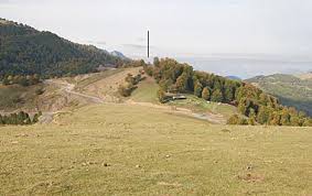
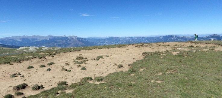
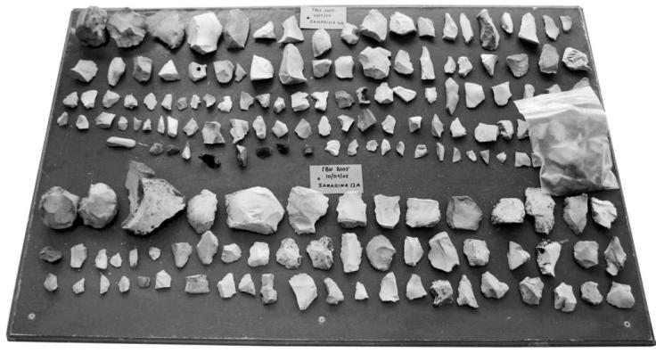
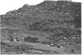
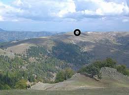
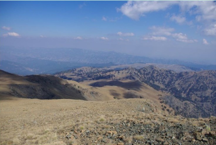
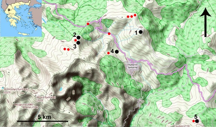
Prehistoric archaeological evidence in the area although at the heart of Palaeolithic Greece (Epirus and Thessaly), was until recently scanty and comprised mainly of surface finds except of material found in the few excavated sites which, however, do not exceed the altitude of 800m (Wilkie and Savina, 1997, 201, Toufexis, 1994, 17; Tourloukis 2010). The aim of the survey undertaken by our team was therefore to go beyond this elevation barrier and concentrate on the ‘archaeology’ of high-altitude and alpine areas which in many places reached the elevation of 2300 m. The main research question put in test was whether high-altitude areas of Greece were systematically exploited during the early prehistory by human groups but their archaeology remained outside the mainstream of modern archaeological research because of its extreme landscape and environmental features. The predictive site-location model employed in the case of Pindus was the one that has been successfully used in similar situations in countries like Italy (Biagi, 1998, 117, 2001, 71) and based on the hypothesis that human groups moving through high-altitude watersheds for hunting-gathering purposes stopped at spots near water sources, seasonal lakes and flint sources for short or longer periods of time. Therefore, the archaeological survey in Grevena region was aimed at producing evidence of hunter-gatherer survival strategies in high-altitude environments and reconstructing local logistical systems. The result of many years (2003-2011) of field walking (collection of surface finds), small scale digs and gathering of palaeoenvironmental data in Pindus was rewarding from many aspects. A total of more than 200 sites – the majority of them belonging to the Middle Palaeolithic – were recorded in the vicinity of the village of Samarina (1600 m) as well as along its watershed to the north (Gorgul’u piedmont, 2200m) but mostly along the Pleistocene terraces of the Smariniotikos river. The richest sites consist of tens of lithics, whereas an average concentration would not exceed a dozen of artefacts in density.
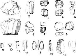
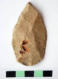
The numerous artefacts collected are made mostly of local white chert but also from radiolarite and quartz. Rich sources of the typical white chert outcrops (quaries) have been located in the area and they are the focus of detailed geological study (Efstratiou et al 2011, 328). The lithic assemblages from the area although without the support of any strati-graphic evidence they seem to support the presence of at least three different complexes. The Middle Palaeolithic tools, mainly cores side scrapers and flakes, belong to Mousterian and Levalloisian assemblages similar with industries from the rest of Greece (Epirus, Thessaly), dated sometime between 50.000 and 40.000 before present (Dakaris 1964 et al, 199, Tourloukis 2010).
Typical Upper Palaeolithic tools such as prismatic bladelet cores and end scrapers while not absent are rather rare and are always made from exogenous chert pebbles. It is also noticeable that Upper Palaeolithic tools were collected from the same Middle Palaeolithic spots indicating that the same watershed was also used by groups of hunters during the last stages of the last Glacial.
Conclusions Our fieldwork in western Pindus has put high-altitude or alpine archaeology back on the archaeological map of Greece. The discovery of a series of open-air Middle Palaeolithic sites in the highlands of central Greece, used by Neanderthal hunter gatherers and associated with Levallois-Mousterian assemblages, explores the idea that these groups exploited environmentally extreme landscape niches, indicating most probably a more complex logistical system than that already suggested for the period (Papagianni 2000). Unless the Samarina high-altitude watersheds where our work has been concentrated, is of unique geographic importance for trans-regional mobility and contacts in this part of Greece, a new model of Middle Palaeolithic (at least) settlement patterns which for the first time opens up new geographical locations for archaeological consideration, should be serious considered.
Moreover, our work in the Pindus has come to emphasize the complexity of the settlement patterns during the Middle Palaeolithic period in Greece as well as the ‘‘large scale’’ and broad reconstructions suggested so far. We came quickly to realize that for understanding the complex logistical systems of exploitation of hunter-gatherer groups, a ‘‘small scale’’ of study which shall incorporate geomorphological information, climatic characteristics, vegetational histories, raw material sources and possible different types of sites (depending on their lithic assemblages), is required. The case of Palaeolithic Pindus is a step forward to that direction.
(Source: “High Altitude Archaeology in Greece. The case of the Palaeolithic Pindus in the Grevena Region”, by Nikos Efstratiou, Paolo Biagi)
The highland zone of the Pindus range considered in this paper plays an important role in the study of the Levallois Middle Paleolithic of southern Europe mainly because of the characteristics of the mountain territory exploited by Neanderthal groups across which they moved, most probably slightly after 70 kyr, as the stratigraphic dislocation of their material remains would suggest. In effect, both the almost treeless landscapes of the Samarina alpine pastures, degraded by centuries of Vlach intensive deforestation, pastoralism,and transhumance (Chang and Tourtellotte 1993), and the scarce human density of the region have undoubtedly favored the discovery of lithic tools along the mountain slopes, making the region of unique importance for the archaeology of the Paleolithic period.
High altitude Levallois Mousterian sites are uncommon in Europe, even in the Alps, for instance, where except for a few cases, the advance and retreat of glaciers have destroyed most traces of Middle Paleolithic activity. This is not the casefor the Pindus uplands where, due to their geographic location and the limited extension of the Pleistocene moraines (Boenzi et al. 1992), the Middle Paleolithic sites were not affected by glacial action. Moving to the east, high altitudeMousterian sites have been discovered in the uplands of Iran, in the Zagros, for instance, although in very different environmental conditions.
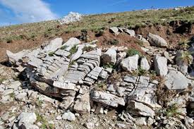
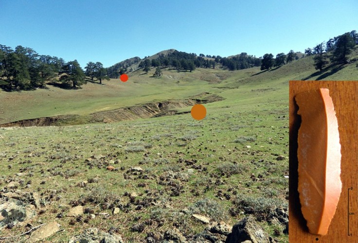
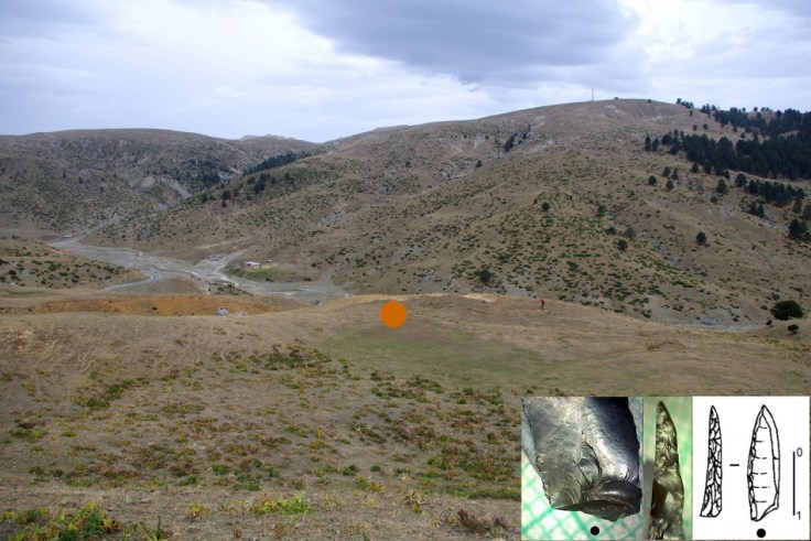
To conclude, the two Levallois sites described above lie some 2 kms, as the crow flies, to the northwest of a very rich outcrop of good quality light gray chert that was discovered at the top of the watershed facing the sites and that was utilized as a primary raw material source. This observation is reinforced by the presence of fractured chert nodules, very large corticated primary flakes, and tested raw material blocks that are scattered over a surface of more than 10,000 m² around the source. These discoveries demonstrated the intense exploitation of the outcrop in Middle Paleolithic times and that the first decortication of the raw material nodules took place on the spot. Large nodules, up to several tens of kilograms, were noticed not only in the above outcrop, but also at shorter distance (ca. 700m) in the alluvial deposits of a narrow seasonal stream that joins the Samariniòtikos just south of the terrace where SMR-1 is located.
The complex pattern described above makes the uplands around Samarina of unique interest for Middle Paleolithic archaeology of Greece and southeastern Europe in general, for which we had very little evidence at high altitudes until a few years ago. Furthermore, it contributes to the study of Neanderthal behavior, landscape exploitation, raw material procurement, and technological choices.
(Source: “Highland Zone Exploitation on Northwestern Greece: The Middle Palaeolithic Levallois Sites of the Pindus Range of Western Macedonia”, by Nikos Efstratiou, Paolo Biagi, Diego E. Angelucci, and Renato Nisbet)
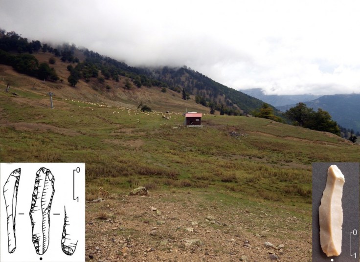
Archaeological surveys and excavations carried out in the Samarina region since 2002, promoted by Aristotle University, Thessaloniki, have led to the discovery of hundreds of high-altitude sites, most of which can be attributed to the Middle Palaeolithic, Mousterian Levalloisian culture. They are mainly distributed along the watersheds that surround Samarina, and the ridges of the Gurgulu, up to an altitude of around 2100m asl (Efstratiou et al. 2004 & 2006). Although their precise chronology is yet to be defined, the location of several assemblages on the top of the most recent moraines, radiometrically dated to some 70 kyr (Hughes et al. 2006 & 2007), and their typological and technological characteristics would assign them to a late period in the development of the Middle Palaeolithic. The assemblages are characterised by artefacts among which are Levalloisian cores, flakes and blades, retouched and unretouched Levalloisian points with facetted platforms and different types of side-scrapers.
High-altitude Mousterian sites are not well known in south-eastern Europe. A few have been discovered at slightly lower altitudes (around 1500m asl) in the western Bulgarian Rhodopes (Ivanova 2006). This makes the discovery of the numerous high-altitude stations and substantial raw material outcrops along the fringes of the Pindus Mountains all the more important; it opens new perspectives for the study of the chronology, resource exploitation and behaviour of the most recent Levalloisian Mousterian bands of the Balkan peninsula.
(Source: “Middle Palaeolithic chert exploitation in the Pindus Mountains of western Macedonia, Greece”, by N. Efstratiou, P. Biagi, D. E. Angelucci & R. Nisbet)
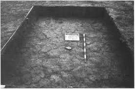
Abstract The surveys and excavations carried out in the highland zone of the Grevena Pindus Mountains have revealed that the watershed that separates western Macedonia from Epirus was (seasonally) inhabited in different prehistoric times, from the Middle Palaeolithic to the Bronze Age. The highest concentration of ‘sites’ is known from the surroundings of the modern village of Samarina, which is rich in good-quality chert raw material outcrops. This territory is still nowadays heavily exploited by Vlach shepherds who seasonally carry out pastoral activities, moving their flocks from the eastern lowlands up to the high-altitude pastures. The excavations carried out at three different sites, all lying on a flysch substratum, revealed the presence of a redeposited lower sediment, characterized by a polygonal soil caused by ground freezing that was later effected by erosion canals produced by human interference in the landscape. The results so far obtained from a few charcoal radiocarbon dates indicate that this fact took place in at least three different periods from the middle Bronze Age to the seventh century ad.
(Source: “Prehistoric exploitation of Grevena highland zones: hunters and herders along the Pindus chain of western Macedonia (Greece)”, by Nikos Efstratiou, Paolo Biagi, Paraskevi Elefanti, Panagiotis Karkanas & Maria Ntinou)
Research-Selection for NovoScriptorium: Philaretus Homerides
