
Archaeological finds were located at the site of Eshta’ol during routine archaeological digs conducted ahead of a planned expansion of Route 38, the main access road to Beit Shemesh, Israel. One of the buildings is the oldest ever found in the area, and constitutes remarkable “evidence of man’s transition to permanent dwellings,” researchers said.
“Settlement remains were unearthed at the site, the earliest of which dates to the beginning of the eighth millennium BCE and latest to the end of the fourth millennium BCE,” the authority said in a statement.
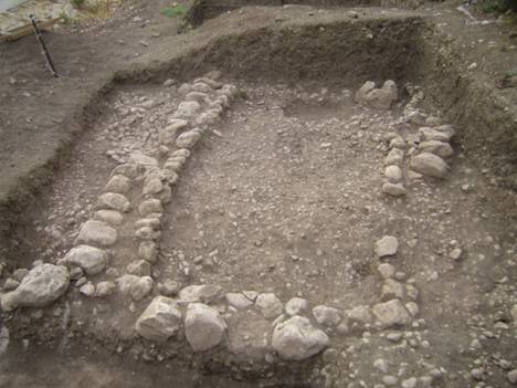
“We uncovered a multitude of unique finds during the excavation,” said Amir Golani, one of the excavators for the Antiquities Authority. “The large excavation affords us a broad picture of the progression and development of the society in the settlement throughout the ages. Thus we can clearly see that in the Early Bronze Age, 5,000 years ago, a rural society made the transition to an urban society. We can see distinctly a settlement that gradually became planned, which included (streets) and buildings that were extremely impressive from the standpoint of their size and the manner of their construction. We can clearly trace the urban planning and see the guiding hand of the settlement’s leadership that chose to regulate the construction in the crowded regions in the center of the settlement and allowed less planning along its periphery.”
The oldest building found dates from the time of the earliest known domestication of plants and animals.
“Whoever built the house did something that was totally innovative because up until this period (local human groups) migrated from place to place in search of food. Here we have evidence of man’s transition to permanent dwellings, and that in fact is the beginning of the domestication of animals and plants; instead of searching out wild sheep, ancient man started raising them near the house,” researchers said in a statement.
The researchers included Golani, Ya‘akov Vardi, Benyamin Storchan and Ron Be’eri, who serve as excavation directors for the Antiquities Authority.
The house is the oldest structure ever found in the Judean lowlands, they said, dating back to the period known to archaeologists as the Pre-Pottery Neolithic.
A handful of buildings from the end of the Chalcolithic period, some 6,000 years ago, was found nearby. At the site, excavators found a six-sided stone column standing some 1.3 meters (51 inches) high and weighing several hundred kilos.
“The standing stone was smoothed and worked on all six of its sides,” the archaeologists said, explaining that its broad face was oriented eastward and concluding that the find ”alludes to the presence of a cultic temple at the site.”
“In the past, numerous manifestations have been found of the cultic practice that existed in the Chalcolithic period. However, from the research, we know of only a few temples” located at Ein Gedi and Teleilat Ghassul in present-day Jordan.
(Source: https://www.archaeology.wiki/blog/2013/11/28/pre-neolithic-architecture-revealed-in-judaea/)

The site of Eshta’ol is situated in the Judean foothills region on a moderate slope on the western bank of the Nahal Kisalon riverbed. The region has a typical Mediterranean environment with an average annual precipitation of 500-600 mm and is covered with forest vegetation. During the past decade, several excavations conducted at the site uncovered remains of multi-period site spanning from the Pre Pottery Neolithic B (hereafter PPNB) to the Intermediate Bronze Age (Golani et al. 2016). The nature of the remains uncovered at Eshta’ol that the site was occupied by a large widespread village. At Esthta’ol, remains of PPNB dwellings were documented in two separate areas of the site at both the upper slope (Areas G and J) and near the valley floor (Area H). In addition, multiple plaster surfaces (unexcavated) have been documented by Israel Antiquities Authority inspectors located between the excavated areas, further indicated the widespread nature of the settlement. The lithic assemblage from the site indicates that the initial occupation at Eshta’ol can be dated to the middle stage of the PPNB period composed of diagnostic Byblos/Jericho arrowheads and sickle blades. The assemblage contains a rather low quantity of debitage which suggests that the arrowheads and sickle blades were probably imported from a separate production site. The PPNB lithic assemblage is similar to that uncovered at the site of Abu Gosh, located 10 km northeast of Eshta’ol.
In Area H the remains of a complete PPNB structure with multiple plaster floors was uncovered. The earliest of the plaster floors within the building was found to cover the building’s walls.
The succession of plaster floors, one resurfaced above another, was probably conducted as routine maintenance of the structures over time. Excavation of the building revealed a few diagnostic lithics and ground stones mostly between the floor surfaces. The eastern portion of the structure was found warped nearly 0.5 m lower than the western side of the building due the Gilgai phenomenon (Kishné et al. 2008) caused by soil swelling and cracking of the grumusol rendzina ground during the summer and loss of volume during the winter season. Similar warping damage from this phenomenon were also noticed in many of the Early Bronze Age structures at the site.
The faunal assemblage from PPNB Eshta’ol consisted of 73 identified bones. The most dominant taxon in this small assemblage is caprines. The PN assemblage is very small, comprising of 13 identified bones. Caprines (N=5, 38%) and cattle (N=5, 38%) are equally represented, with single bones of gazelle, dog, and mole rat. Ongoing analysis incorporating the EB sample is expected to highlight economic change through time at the site.
Early Pottery Neolithic remains were uncovered in several locations at the site and include the remains of two structures. The diagnostic finds associated with this period can be attributed to the Jericho IX/Lodian material culture. The lithic assemblage is characterized by a flake based industry including small arrowheads (Nizzanim and Haparsa types) and denticulated sickle blades modified by pressure flaking. The ceramic assemblage is composed of mostly open form vessels with colored band decorations. Within one of the structures, a cache of stone and flint bifacial tools were found together with three roughouts and a stone anvil. Additional finds from this period include a concentration of cereal seeds identified as Triticum aestivum/compactum and dated to the end of the 7th millennia (BCE cal.). The dating accords well with other occurences of the Lodian material culture at other sites.
(Source: “Poster: The Neolithic site of Eshta’ol”, by Jacob Vardi et al.)

After a near decade of surface surveys, archaeological inspection, mechanical test trenches and rescue excavations undertaken within Moshav Eshta’ol, extensive remains of a large, previously unknown pre- and proto-historic settlement have been revealed. Eshta’ol is located in the Judean foothills, just north of Beth Shemesh and alongside of modern Road no. 38. The majority of excavations at the site have been conducted by the Israel Antiquities Authority (henceforth IAA) although other institutions have taken part as well. All these have determined that the site is composed of two separate non-overlapping settlement areas.
The larger of the two settlement areas extends over an area of nearly 170 dunams, bordered by Nahal Eshta’ol (Road no. 38) in the southeast and a high bedrock cliff located approx. 350 m to the northwest, within the borders of the modern moshav. The earliest occupation in this area was during the Pre-Pottery Neolithic B (henceforth PPNB) period, continuing during the Pottery Neolithic A (Jericho IX phase, henceforth PNA) and the Chalcolithic (Ghassulian phase) period. The settlement size during each of these earlier periods is still unknown, yet the site appears to have reached its pinnacle during the late Early Bronze I (henceforth late EB I) and for reasons unknown, was then abandoned. The smaller settlement area, covering approximately 70 dunams, is found immediately to the northwest of the larger site and was inhabited primarily during the Intermediate Bronze Age (henceforth IBA).
History of Research During 2013, prior to widening of Road no. 38, the most extensive excavations at the site to date were directed by A. Golani, D. Storchan, R. Be’eri and Y. Vardi and were carried out on behalf of the IAA adjacent and parallel to Area D. These excavations revealed a complete building dated to the PPNB period, scattered architectural remains of the PNA period and three settlement phases of the late EB I. Within the context of this excavation season, an additional excavation area, (Area J, directed by Z. Matskevich, unpublished), was opened in proximity to Areas F and G mentioned earlier. Excavation in this area revealed further remains of the PPNB period and several phases of building remains from the Chalcolithic period that included a large standing massebah. In the smaller settlement area of the Eshta’ol site, building remains of the Intermediate Bronze Age were exposed in Areas C and E (Freikman 2010; Golani and Storchan 2009).
The occupational history at the larger settlement area at Eshta’ol may thus be defined in four major occupational periods: the PPNB, the PNA (Jericho IX phase, Lodian culture), the Chalcolithic (Ghassulian phase) and the late EB I (‘Erani C phase) periods. The accumulated excavations at the larger pre-historic and proto-historic settlement have so far exposed only 1.5% of that site. The accumulated excavations at the smaller, adjacent IBA settlement have so far exposed only 3% of the latter site. The following table summarizes the stratigraphic profile of both settlement areas as identified in all the excavations to date.
Chronological and Historical Setting The combined results of all the excavations show at least three distinct settlement phases during the late EB I period. All three show a gradual development not punctuated by traumatic events, in which buildings were reused and altered over time and in which new buildings and architectural styles replaced previous constructions. In terms of the ceramics, there do not appear to have been any significant differences between the three successive phases and they are all associated to the ‘Erani C’ cultural horizon within the middle to late EB I (e.g. Yekutieli 2006), generally dated within the third quarter of the fourth millennium BCE (3400–3250 BCE).
The ‘Erani C’ cultural horizon is well-known not only from its ‘type site’ at Tel ‘Erani where it was first defined, but also at numerous other sites of the EB I in southwestern Canaan, among them Hartuv in the immediate vicinity of Eshta’ol (Mazar and Miroschedji 1996) and at Taur Ikhbeineh (Oren and Yekutieli 1992). This phase of the late EB I is characterized by Egyptian ‘colonial’, or more accurately, ‘economic’ exploitation of southwestern Canaan and is equivalent to the Naqada IIc–d – IIIa period in pre-dynastic Egypt (Miroschedji 2002). At Tel ‘Erani, this chrono-cultural phase was found to immediately precede the very last phase of the late EB I, which at sites in southwestern Canaan such as Tell es-Sakan, ‘Ein Besor, Tell Ma’ahaz and Lod, bears clear evidence of developed Egyptian trading outposts in southwestern Canaan and is equivalent to the Egyptian Dynasty 0 (Naqada IIIb). Though the exact nature of Egyptian involvement, whether bi-lateral trade relations or colonization is still to be fully clarified (e.g. Miroschedji 2002; Braun et al. 2001), it is perhaps significant that Eshta’ol flourished during the ‘Erani C’ phase yet was subsequently abandoned immediately afterwards at the same time that Egyptian influence in southern Canaan was on the rise. The proto-historic settlement history of Eshta’ol is paralleled at the nearby site of Hartuv (Mazar and Miroschedji 1996) which was also settled during the ‘Erani C’ chrono-cultural phase and then peacefully abandoned. The material culture at Eshta’ol, like Hartuv, includes only a minimal amount of Egyptian or Egyptian-related objects, conforming to the period of limited Egyptian presence in southern Canaan prior to the foundation of Egyptian trading outposts or colonies in southwestern Canaan at the very end of the EB I period (Miroschedji 2002). In contrast, the site of Horvat ‘Illin Tahtit (Braun 2008a) was found to contain a more significant amount of Egyptian material. This latter site, located some 4 km to the south of Eshta’ol, was first settled in the post-Erani C period and suffered a violent destruction during its occupational time-span.

Intra-Site Transitions at Eshta’ol – Core/Periphery Density Observations Perhaps one of the most important contributions of the Eshta’ol excavations to our knowledge and understanding of the Early Bronze Age in the region is that the large-scale exposure (unlike smaller excavations) and subsequent comparison of the various excavated areas allow for the identification of intra-site transitions. These can be further examined in a core-periphery spatial analysis and changes over time within the site.The largest exposure of EB I remains at Eshta’ol was found in Areas D and H. Both these areas are positioned at the southeastern fringe of the site, parallel and adjacent to Road no. 38 and Wadi Ishwa itself. Surface surveys, archaeological inspection and limited excavations to the southeast of this streambed as well as within and around the site (Golani 2011; Storchan 2010) have not revealed any significant remains dating to the EB I period, suggesting that the streambed delineated the southeastern limit of the site.
Within these two excavation areas, numerous architectural elements were revealed. These consisted of broadroom structures generally found with benches along their walls, separated from one another by alleyways and related to rounded storage structures. The broadrooms were generally similar in size, yet one structure was exceptionally large and may have been used as a public building. In the northeastern portion of both Areas D and H, a dense concentration of EB I building remains throughout all the settlement phases was revealed, while towards the southwest, the building density clearly diminishes. This situation is also reflected in the occupational buildup itself; where the depth and nature of the debris was thick in the northeast, thinning out significantly towards the southwest. This suggests that the northeastern portion of Areas D and H is near or if not at the core of the settlement, while the transition to the periphery is found to the southwest.
Excavations in the upslope region of the site (Areas F and G), uncovered additional EB I remains, yet these were not as densely constructed as in the northeastern portion of Areas D and H. This is further evidence that settlement density follows a radiating pattern, ultimately apparently fading out in relation to a growing distance from the core of the site. The change in building density at Eshta’ol can be related to distance from the core, however the size of at least eight domestic buildings does not show any significant difference in dimensions (±6×8 m average). The buildings appear to follow a similar architectural plan from the core to the periphery, yet do not show significant changes in size.
Intra-Site Transitions and Development In many instances, the transition from phase to phase was characterized by a great deal of continuity as seen in the reuse and modification of existing structures. Notably, throughout all three phases, most of the buildings retained the same orientation, suggesting that throughout the EB I, the settlement was constructed according to a pre-conceived plan.
Conclusions The extensive excavations at Eshta’ol, provide a wealth of information regarding the intra-site and external factors that can be seen to have a direct effect on the site’s nature, composition and development. The large-scale exposure of the EB I settlement clearly shows a radial model of spatial density related to distance from the core of the settlement. It is of little surprise that the largest rounded-corner building found at Eshta’ol, perhaps a public structure, was found at the central core area of the site, already during the initial EB I settlement of Phase 3, and continued into Phase 2.
At Eshta’ol, nearly all clear building units were noticed to have shared a similar orientation. Over time, this planning principle appears to become more regulated, even when the density of the structures decreases, suggesting that the development of municipal planning at the site became more entrenched during the site’s development. This is further noted during the last phase of EB occupation by the appearance of pre-conceived alleyways. This may have been the ultimate response to the over-packed building conditions seen in Phase 2. For reasons unknown, the site was eventually abandoned during Phase 1.
At Eshta’ol, the changes in site size and core-periphery densities during the transition from Phase 3 to Phase 1 provide insights regarding the initial stages of the urbanization process at a time also known as the ‘proto-urban’ period. This is expressed in the seeming growth of settlement size during the transition from Phase 3 to Phase 2 along with increased core density. It appears that over time the site shows increasingly organized planning, probably coinciding with increased social stratification and complexity.
The site of Eshta’ol existed in a much larger regional socio-political framework and along with the nearby site of Hartuv, both may be seen as two regional type-sites of the upper Soreq basin during the floruit of settlement that characterized the late EB I of the southern Levant. Both sites were abandoned peacefully, on the very eve of urbanization, when Egyptian cultural influence was on the rise further south. In the same region, after Eshta’ol and Hartuv were abandoned, sites such as Horvat ‘Illin Tahtit and Beqo’a were immediately settled and later destroyed or abandoned at the very end of the EB I – the transition to the EB II. The subsequent transition into the fully urban EB II in the upper Soreq basin is then marked by a contraction of settlements to larger fortified centers such as Tel Yarmuth. This scenario appears to partially support the ‘settlement crisis’ theory in which many sites of the Late EB I in the southern Levant were abandoned and not resettled during the EB II, and that many sites of the late EB I appeared to have shrunk in favor of population concentrations in fortified urban centers during the EB II period (Gophna and Portugali 1993).
(Source: “Eshta’ol – A Proto-Historic Site in Transition: Preliminary Inter/Intra-Site Observations”, by Amir Golani and Benjamin Dan Storchan)

Research-Selection for NovoScriptorium: Philaretus Homerides

Leave a comment