, Greece; the ancient shipwreck (58 discovered so far) capital of the world")
This post is dedicated to the exciting (Underwater) Archaeological discovery of tens of shipwrecks (58 so far) at the bottom of the Aegean Sea, at the Archipelago of Fourni (or Fournoi), Greece.
About The Fournoi Underwater Survey
The joint Greek-American expedition to the Fournoi archipelago found twenty-three new shipwrecks dating from the Late Archaic period through the 19th century AD. Twenty-two shipwrecks were identified during the first season in September 2015. This number represents 12% of the known wrecks in Greek waters, demonstrating the navigational significance of the islands. Twenty-three additional shipwrecks were discovered in June 2016, bringing the total to 45 wrecks in the last 9 months. As a substantive dataset of vessels lost underway, as opposed to abandonments or harbor assemblages, the Fournoi assemblage offers a comparative collection for understanding eastern Mediterranean sites.

The Fournoi Underwater Survey is one of the most exciting projects currently in archaeology. With the identification of 45 shipwrecks and much more coastline to search, Fournoi may have one of the largest concentrations of ancient shipwrecks in the world. This is because the archipelago is situated at a pivotal location within the Aegean. It is one of the few islands with both northern and southern currents. Its location is the convergence of two major sailing routes, used both in Antiquity and today due to the natural condition of winds in the region.
The second season of the Fournoi Underwater Survey was conducted from 8 June to 2 July 2016 and expanded the project, conducting broader surveys to locate additional sites. In addition, more focused research was conducted on each of the previously located sites, supplementing the data collected in 2015. The survey is a collaboration between the Ephorate of Underwater Antiquities/Hellenic Ministry of Culture and Sports and RPM Nautical Foundation. The research is directed by George Koutsouflakis from the EUA and Peter Campbell from RPMNF/University of Southampton. The goal of the survey is the identification and documentation ancient, Medieval, and post-Medieval shipwrecks in the Fournoi archipelago.
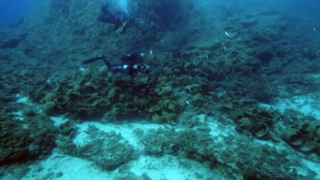
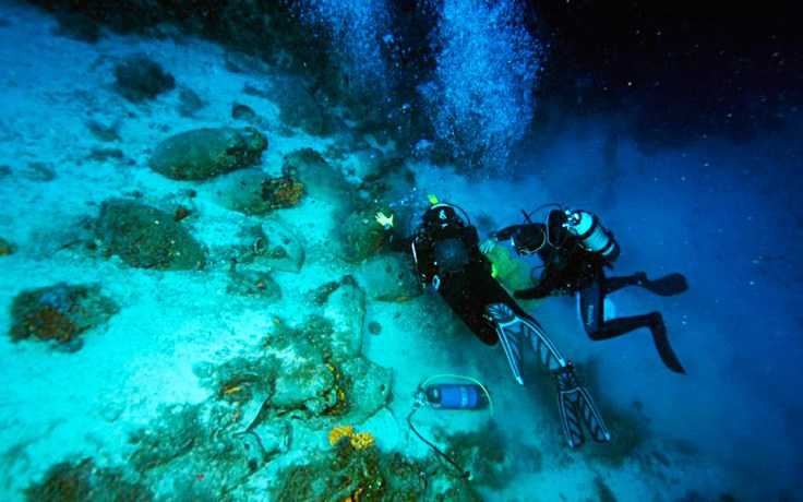
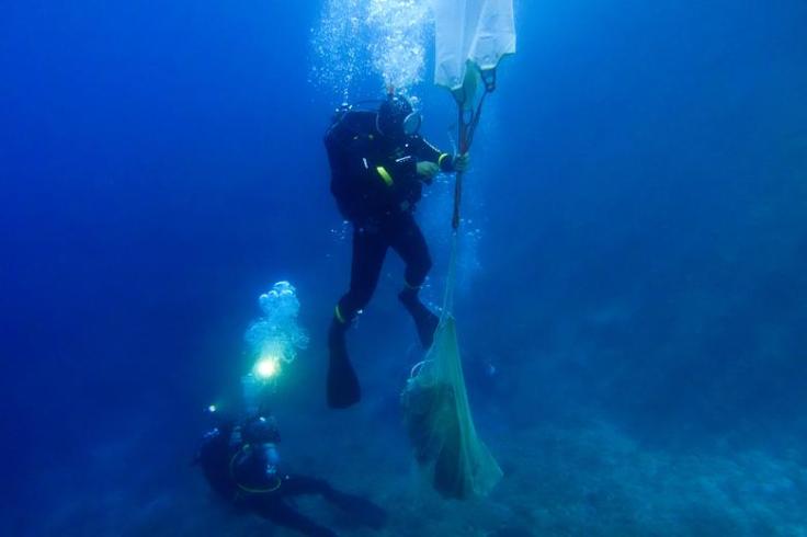
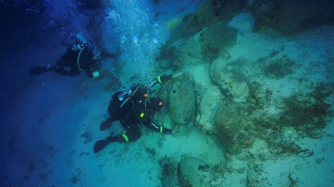
The success of the project is attributable to working with the local community. The research consists primarily of scuba diving along the coastline to depths up to 65 meters. The project has covered less than 50% of the archipelago’s coastline with diver surveys, leaving a many regions, especially deepwater areas, to explore. “The concentration of the shipwrecks and the large area remaining to be explored leaves every indication that there are many more sites to discover,” says Peter Campbell, project director from US based RPM Nautical Foundation. “We expect more seasons like these first two. The Fournoi dataset offers great insight into ancient navigation and trade.”
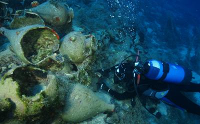
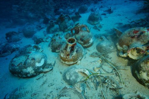
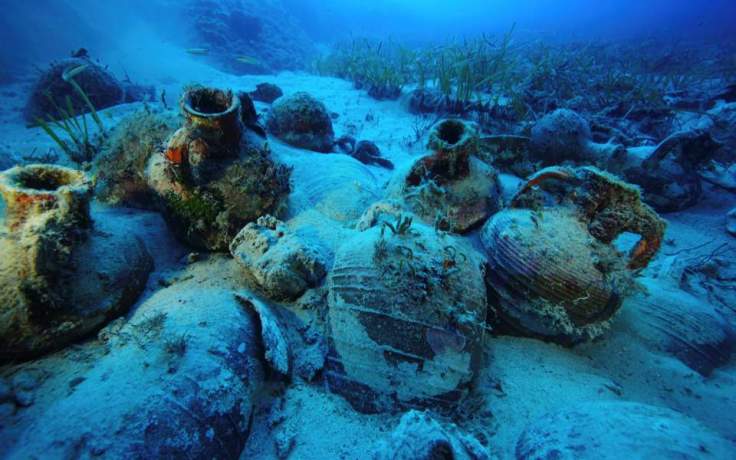
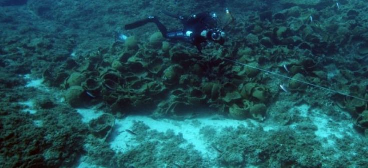
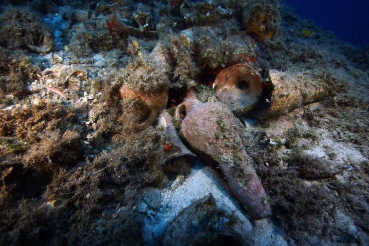
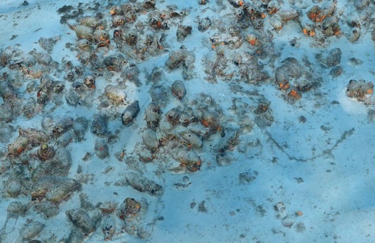
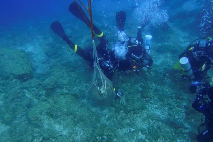
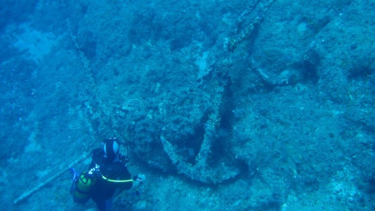
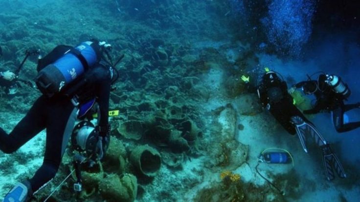
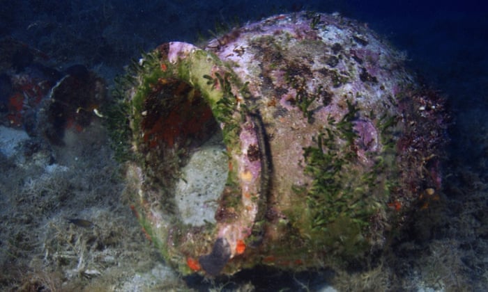
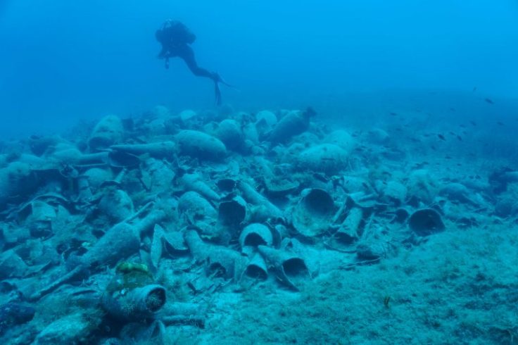
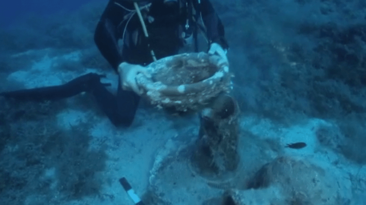
The most significant shipwrecks of 2016 were a Late Archaic-early Classical wreck with amphorae from the eastern Aegean, a Hellenistic cargo of amphoras from Kos, three Roman cargos of Sinopean amphorae, a wreck of North African amphorae of the 3rd-4th century AD, and a cargo of Late Roman tableware. Two massive stone-stocks of ancient anchors dating to the Archaic Period are the largest found in the Aegean so far. The ships span the late Archaic Period (c. 525-480 BC) to the Early Modern Period (c. 1750-1850). Beside shipwrecks, the project documented a large number of finds such as jettisoned pottery and ancient anchors. The finds reveal the importance of eastern Mediterranean trade networks passing by Fournoi in every time period, connecting the Black Sea and Aegean to Cyprus, the Levant, and Egypt. Some shipwrecks even carried goods from North Africa, Spain, and Italy.
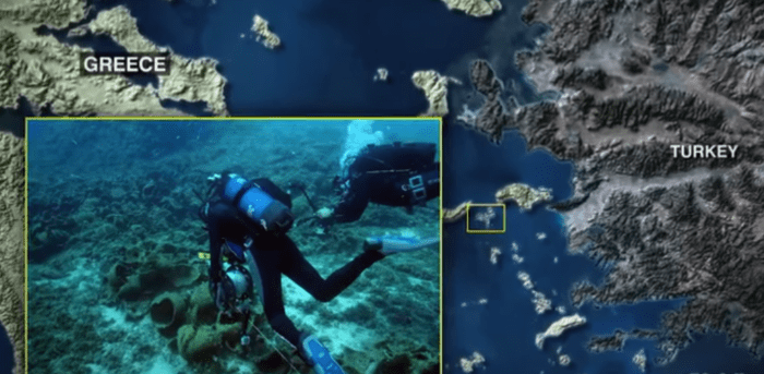
Fournoi is a collection of 13 islands and islets between the Aegean islands of Samos and Icaria. The small islands never had large settlements, instead its importance comes from its critical role as an anchorage and navigational point in the eastern Aegean. Fournoi lies along a major east-west crossing route, as well as the primary north-south route that connected the Aegean to the Levant.

For comparison, many larger islands around the Mediterranean have only three or four known shipwrecks. The United States recently created a national marine sanctuary in Lake Michigan to protect 39 known shipwrecks located in 875 square miles. Fournoi has 45 known shipwrecks around its 17 square mile territory.
The expedition was funded by the Honor Frost Foundation, a UK charity founded with an endowment by pioneer maritime archaeologist Honor Frost that funds research in the eastern Mediterranean, and Deep Blue Explorers, a NGO for applied marine and atmospheric science based in Cres, Croatia. Sponsorship and assistance were provided by George Koumbas, Carrefour Ikaria, Municipality of Fournoi Korseon, Business Association of Fournoi, Port Police, and Field Notes.
The previous seasons suggest a great deal more shipwrecks await discovery in the archipelago. The project plans to continue the survey and fully catalog and document the underwater cultural heritage of the archipelago and learn more about ancient trade and navigation in the Aegean Sea. After completing a full survey of the archipelago’s underwater cultural resources, the project will consider excavating shipwrecks of significant scientific value.
(Source: https://rpmnautical.org/projects/fournoi-shipwreck-survey/)
Results from 2018
During the 2018 research season, traces of five shipwrecks were located and documented, dating from the Hellenistic and Roman period and later times. The total number of shipwrecks that were located and documented along with those already surveyed and recorded between 2015 and 2017 comes to 58. Apart from the wrecks, isolated finds were also recorded, mainly ceramic rejects and anchors, reliable indicators of the extensive shipping and traffic of freight at this crucial nautical crossroad of the eastern Aegean.
Among the most remarkable finds of the 2018 survey is a wreck with a cargo of Knidian amphorae of the 2nd century BC, a wreck of the 4th c. BC with a mixed cargo of Aegean and Phoenician amphorae and a 5th-6th c. AD wreck with a cargo of Late Roman Amphorae 1.

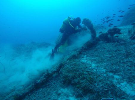
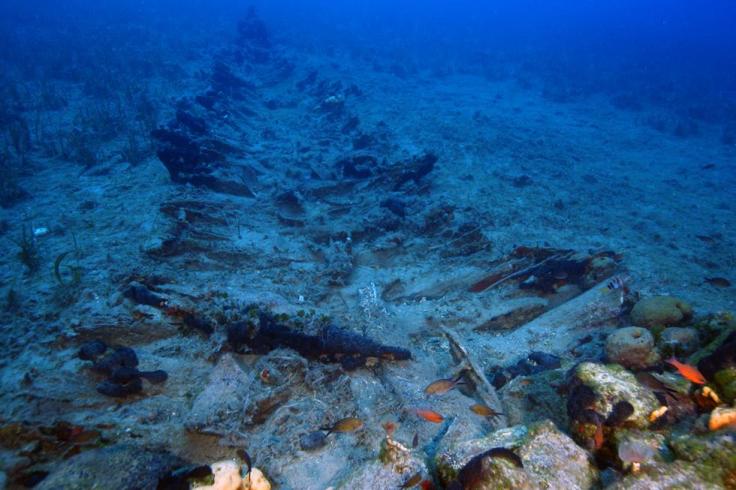
One important discovery was the location and documentation of an extremely extensive anchorage behind the Kamari settlement on the east side of Fournoi. Over 25 anchors were identified dating from the Roman era to the 18th century, most of which had been abandoned on the sea bed by remarkably big ships.
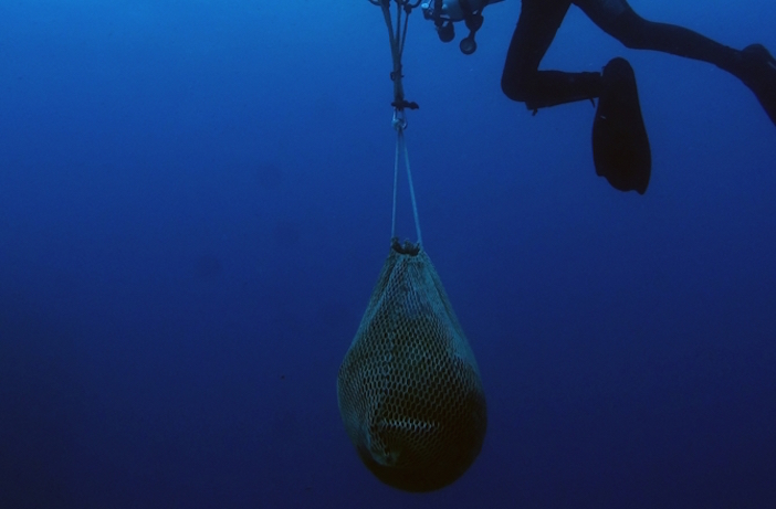
The most interesting single finds of 2018 include a deposit of at least 18 clay oil lamps of the 2nd century AD that was found and recovered on the north side of Thymaina island. These lamps feature a variety of imagery in relief such as gods, gladiator scenes and geometric jewelry, all produced by Corinthian workshops.

Shipwreck capital of the world – A 2017 presentation with interviews
The Archipelago of Fourni, an insignificant group of Greek islands in the Aegean, lies at the crossroads of ancient north-south trade routes connecting the Black Sea to Alexandria and the eastern Mediterranean and east-west routes to Spain and Italy.
“Despite the sheer number of wrecks found, Fourni isn’t naturally a dangerous place,” says Peter Campbell, a British School at Rome archaeologist and co-director of the Greek- American expedition. “Because the vessels sank complete with their cargoes, what we see in the 53 wrecks we have discovered so far is an incredible snapshot of trade over 25 centuries.”
Campbell believes his team in Rome, and at the RPM Nautical Foundation in the US, working with the Greek Ephorate of Underwater Antiquities, have many more shipwrecks to find in the area. “Fourni has already added over 24 per cent to the list of known ancient shipwrecks in Greek territorial waters and we still have much more of the seabed to search. Fifty per cent of the coastline remains to be explored by our divers, and we have only surveyed 5 per cent of the deep water areas,” he adds.
The sheer number of wrecks reflects the large volume of traffic through this maritime navigational choke point in the Eastern Mediterranean. In a way, it is like comparing statistics of car accidents on a dangerous road and a good road, to find that accidents are higher on the good road. This can only happen if the number of cars travelling along the good road is considerably larger.
Campbell first arrived in Fourni when conducting ethnographic research with local sponge divers in Kalymnos, a village on one of the Fourni group. “We made a map of the region and marked where the sponge divers had seen shipwrecks. The results were so promising that I went to meet George Koutsouflakis from the Greek Ephorate of Underwater Antiquities in Athens. He too had a map from local Fourni fishermen of possible wrecks around the island. We decided to explore the island together. That was back in 2015 and we have not been able to leave Fourni since, there are so many shipwrecks there,” says Campbell.
His and Koutsouflakis’s low-tech, low-cost, people-based approach has delivered wrecks at 50 per cent of the sites they were told about. These interviews with fishermen and divers were critical to getting the project off the ground.
Fourni is not an obvious place to search for ancient wrecks. It has never been home to any ancient trading cities, only a few fishing villages; and even references to the islands are very sparse in ancient literature, so it’s not likely the islands would have attracted the attention of marine archaeologists for hundreds of years to come, if ever.

“What we are seeing are the very unlucky few,” says Campbell. “Many of the wrecks have clearly been anchored up, sheltering in the lee of the cliffs from the prevailing northerlies.
All it takes is for that wind to swing around to the south quickly when the crew is asleep or not alert, and the vessels will be blown into the base of the cliffs. Many wrecks show the same unfortunate pattern, a smashing and falling back, scattering their cargoes from the shallows into the deep.”

Most of the time, wreck-hunting marine archaeologists use expensive sonar-equipped ships, capable of holding a geostationary position so robotic remotely operated vehicles, or ROVs, can search the seabed while tethered to the ship. These specialised vessels are both expensive and hard to charter at short notice. The team used the RPM Nautical Foundation’s ship Hercules in 2017 to explore an area of seabed which is too deep for human divers, but have had limited success to date.
“What is astonishing about Fourni is not only the number of the shipwrecks, but also the diversity of the cargoes, some of which have been found for the first time on any ancient shipwrecks,” says Campbell’s Greek co-director Koutsouflakis. “We intend to be working at this site for at least another 10 years; there is so much to be documented, we could easily end our careers here,” added the 49-year-old, laughing.
Right now, Koutsouflakis and Campbell are busy documenting what is turning out to be the shipwreck capital of the world. Ultimately the Ephorate may decide to select one of the many wrecks that would make a major contribution to historical and archaeological knowledge, containing a rare or unique cargo, being well preserved with an extensive part of the hull remaining, and accessible and safe to excavate in its entirety.
“If we have the finance in place for a total excavation of a cargo and the shipwreck’s hull, the best case scenario is a 5- to 10-year operation taking us into the 2020s,” says Koutsouflakis.
To put the magnitude of the importance of the finds at Fourni into context, the US is proposing a national marine sanctuary in Lake Michigan to protect 39 known shipwrecks in 875 square miles of water. Fourni now has 53 known wrecks in only 17 square miles, and that number is only expected to rise.

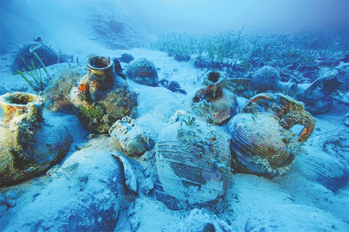
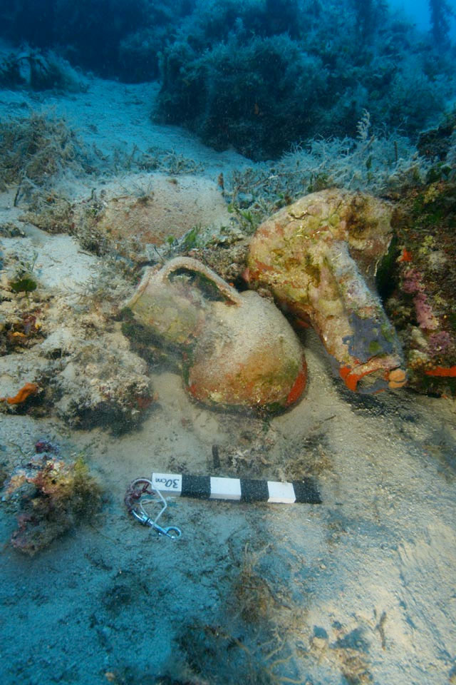
Obviously all organic matter carried by the ships such as grain has long since been eaten by sea creatures. The large clay amphoras – the biggest originate from the Crimea and hold 70 litres – now lie empty, but their shape and design tell us of their port of origin, their original contents and direction of trade in ancient times. It is clear there was a significant international wine trade with wines from Spain and Italy exchanged widely. Like today, wines or olive oil of quality travelled far, while poorer wines and oils were consumed near to home.
Another common find is containers that held garum, a fermented fish sauce, a favourite Greek and Roman condiment similar to soy sauce. Garum was hugely popular in Roman cuisine and has been found in cargoes coming from North African wrecks. Another wreck carried dinner plates dating to the late Roman period.
“The underwater visibility is incredible, usually 20m or more,” says Campbell. “We have no difficulty spotting artefacts or wreck remains at all. The conditions are about as ideal as you can get. As an archaeologist, I could not have dreamed of a better place to work.”
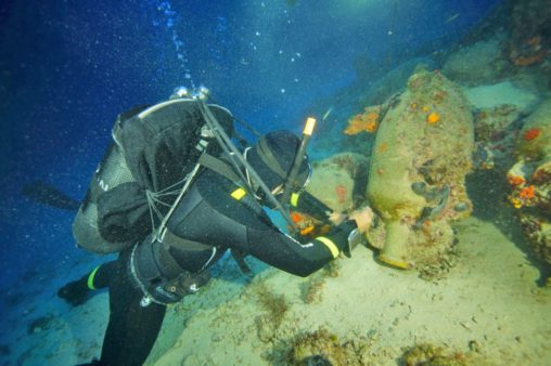
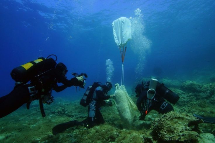
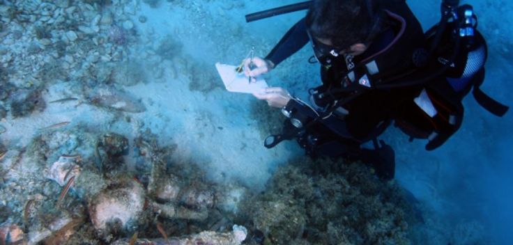
Each site is recorded, meticulously photographed and measured using a technique called photogrammetry. Digital underwater cameras and strobes record an overlapping mosaic of images, which can subsequently be post-processed by software to create a centimetre-accurate 3D model of each wreck site. This is known as photo-mosaicing.

These images record the state of each site, which can be checked for deterioration or disturbance over time, and of course can be interrogated by archaeologists of the future who won’t even have to get wet.
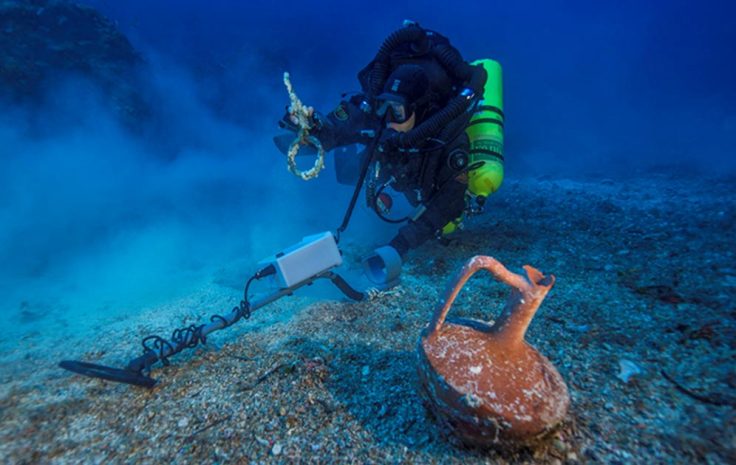
In deeper areas inaccessible to the divers, RPM Nautical Foundation’s research vessel Hercules uses remote sensing equipment and ROVs to survey the bottom topography and
assist in the survey and documentation of the shipwrecks. Key tools are the hull-mounted multi-beam sonar, which gives the archaeologists a high-resolution map of the seafloor down to 90m. To date, only 5 per cent of the deeper waters have been surveyed in this way.
(Source: “Fourni – Shipwreck capital of the world?”, by Louise Murray)

Abstract The underwater archaeological survey at Fourni (2015-2018) aims to identify and document ancient, Medieval, and Post-Medieval shipwrecks. The archipelago comprises 13 islands and islets in the eastern Aegean, which ancient texts referred to as Korseai until it was renamed Fourni during the Medieval period. The survey is sponsored by the Honor Frost Foundation, and conducted by the Hellenic Ephorate of Underwater Antiquities, in cooperation with RPM Nautical Foundation.
The 2015 and 2016 campaigns were conducted using traditional coastal survey methods to depths of 60m. They revealed remains of an unprecedented number of shipwrecks, unexpectedly highlighting Fourni-Korseai – a topos rarely mentioned in ancient literature – as an important navigational node and stepping stone for sea traffic in the eastern Aegean.
Amphora cargoes dominate the long list of newly discovered shipwrecks. The amphora types span the Archaic to the Late Byzantine periods, with amphoras originating from workshops as far apart as the Roman North African provinces and the Black Sea.
This paper presents new evidence of amphora transport based on the Fourni Underwater Survey, and compares it to the existing data from the Aegean Sea. It offers an interpretation of the ancient trade that connected the eastern Mediterranean via the Fourni archipelago.
(Source: “Evidence of Ancient Trade from the Fourni Archipelago, Greece”, by Peter B. Campbell, George Koutsouflakis)

Research-Selection for NovoScriptorium: Philaretus Homerides

Reblogged this on ilcantooscuro.
LikeLike