
The Declination Angle is the angle between Magnetic North (horizontal component direction as shown by a magnetic compass) and True North. It has a different value from one geographical location to another and also changes with time moving East or West of True North, thus the term secular variation. It is one of the three magnetic parameters of the Geomagnetic field.
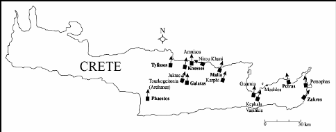
Figure 1
The Protopalatial period (MMI ‐ MMII) (Middle Minoan) is reported to have lasted from ca. 1900 BC to 1750 BC, about 150 years and over the course of this period the construction of the first Minoan Palaces at Phaestos, Knossos and Malia transformed the Island’s history.
The angle orientations between the main Minoan Protopalatial Palace’s (Central Court long axes) are significantly different but there was no apparent reason to suspect that the orientations were not simply “random”, or approximating North‐South to facilitate passive heating/cooling, or for some other reason, possibly religious or astronomical.
Liritzis and Vassiliou (2006a) report that Ancient Greeks saw the Aurora Borealis strongly enough to associate it with particular Gods (hyperborean Apollo) and to build temples of unusual orientation. As such, 14 oriented temples of Apollo from ancient Greece and its colonies have been identified. Liritzis (1988) also has used aurorae and inclinations for archaeomagnetic dating. Although astronomical targets may have been only one amongst several factors that determined the orientation of ancient buildings, arguments drawn from ancient literature support contemporary archaeomagnetic research on virtual pole shift, that points to intentional orientation towards a celestial phenomenon, either aurorae or sunrise.
It has been suggested that the orientations of Minoan Palaces were deliberately oriented towards the ‘East’ and the rising sun and that the rough North‐South orientation of the Palaces were connected to the function of the Central Court or were aligned to solar and lunar orientations. Orientation explanations in the literature have referred to, “rising sun at equinoxes and solstices”, (Blomberg and Henriksson, 2001) and “N‐S, NE‐SW, rough N‐S, arbitrary N‐S, E‐W orientation” (MacEnroe, 2010). However, orientations are, in fact, clearly different and specific.
It is important to note that magnetic compass orientations are not universal. Minoan building orientations range from East to West of North through a angle of ~103° as indicated, for example, by the ‘extreme’ orientations of Kato Zakros (Central Court long axis), +37°, (+ sign denotes, East of North) and Nirou Khani (Minoan Hall/forehall long axis), ‐66°, (‐ sign denotes, West of North).
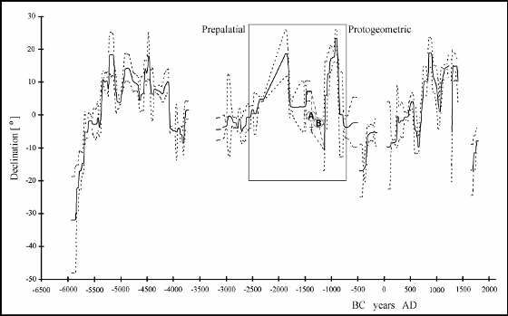
Figure 2
Use of Archaeomagnetic Secular Variation
Archaeomagnetic secular variation curves for the past geomagnetic field are established by measuring appropriate materials from the pre‐historic past, including, burnt mud brick walls, baked clay from oven plasters, kilns, burnt floor layers subjected to ancient fires. It must be noted, however, that in general, archaeological sites suffer from the absence of precise dating because of the problems of contradictions within the calibrated 14C dates.
Material containing suitable magnetic grains after being subjected to heating above, about 700°C, record, on cooling the ‘elements’ (Declination, Inclination and Intensity or strength) of the ambient geomagnetic field.
The angular deviations from True North of some Minoan buildings were compared to the Age‐Declination [Archaeomagnetic secular variation of declination Reference Curve (ARC)], magnetogram, for Bulgaria (Kovacheva et al, 1998), with particular interest in any meetings (intersections) of the ARC by building orientations from the period between ~2400 BC and ~900 BC (Fig. 2). The older archaeomagnetic data from 0 – 6000 BC is arguably the best secular variation record in the world (Kovacheva et al, 1998). Bulgaria, which is due north of Crete has currently a declination difference between the two locations of less than 10 and the use of the Bulgarian ARC for comparisons with Cretan building orientations, presumes, that, the declination difference, during the ‘period of archaeological interest’ was of a similar value.
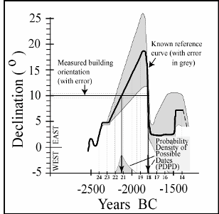
Figure 3
Minoan Building Orientations
The long‐axes orientations of the Central Courts of the six main Palace sites and the ‘N‐S’ walls within other sites were measured and their orientations compared to True North.
The orientations of the Central Courts’ long axes for the main Palace sites which meet the mean of the [Archaeomagnetic secular variation of declination Reference Curve (ARC)], magnetogram, for Bulgaria, Kovacheva et al (1998), (Fig. 2) are shown in (Figs. 3 and 4).
The Protopalatial Palace at Knossos is oriented at +100 and this angle meets the ARC at two points (example Fig. 3), firstly at ~2120 BC. It must be noted, that, at Knossos, there is an EM III (Early Minoan), (Late Prepalatial) facade beneath the later Protopalatial Palace, aligned in the same orientation as the Protopalatial walls.
These walls “represent only a small part of a grand undertaking…. at the heart of the settlement, much of the hill was leveled and a terrace, as massive in scale as the corresponding section of the later Palace, was constructed” (MacEnroe, 2010). This indicates the lengths, to which, architects and builders would go to, in order to achieve the preferred orientation. This orientation suggests that a magnetic compass may have been used during the late EM III period.
The orientation of the Central Court of the Palace at Malia is oriented at +18° and intersects the ARC in the ‘period of interest’ at two points (Fig. 4a), giving possible dates of ~1900 BC and ~1840 BC, both of which, it could be argued, are plausibly within the reputed archaeological time‐frame.
The Protopalatial Palace at Phaestos is oriented at +3° and this intersects the ARC twice, firstly at ~1765 BC (MM II) (MacEnroe, 2010), in archaeological context, possibly the most likely date and again at ~1490 BC.
The buildings to the west of the main Palace at Galatas are oriented at +6°, intersecting the ARC at ~1800 BC, the most likely date in archaeological context and again at ~1475 BC. The +4° orientation of the main Palace’s central court, intersects the ARC at two points (Fig. 4c), firstly at ~1790 BC and again at ~1485 BC.
Orientations of other significant Minoan building sites throughout Central and Eastern Crete (Fig. 1), that appear to have been oriented using a magnetic compass, are shown in (Figs 4 and 5). Some building orientations suggest construction contemporaneity.
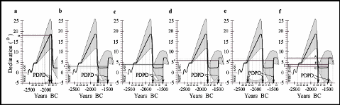
Figure 4
Mochlos (Artisan’s quarter workshops)
Buildings A and B at this site are dated as Neopalatial (MacEnroe, 2010). However, the ‘NS’ east walls of rooms 1, 4 and 10, (Building A), (Fig. 4a) if a magnetic compass was used, are oriented at +18°, the same orientation as the Protopalatial Palace at Malia.
For Building B, the ‘N‐S’ west walls of rooms 1,2 and 7‐12 are oriented at +6° showing intersections with the ARC at ~1800 BC and at ~1475 BC.
Tylissos
The site plan taken from Sakellarakis and Sapouna‐Sakellaraki (1997) indicates that the “askew” Houses A, B and C are respectively orientated at, (+7°, +4° and +3°) and have been dated from 1700 BC to 1500 BC. (Warren and Hankey, 1989), however, the intersections of the house orientations with the ARC suggests somewhat earlier dates, between ~1805 BC and ~1765 BC.
Amenospilia Sanctuary
The “N‐S” parallel walls of rooms 1 to 5 are oriented at +6°, giving possible dates at ~1800 BC and ~1490 BC. The site is dated MM IIB – MM III (MacEnroe, 2010) which is consistent with the earlier archaeomagnetic date.
Quartier Mu (Malia)
The Protopalatial building A, is described as the “grandest structure known from the Protopalatial period” (MacEnroe, 2010) and is oriented at +3°, the same orientation as the Protopalatial Palace at Phaestos.
Amnisos
“The Late Minoan settlement at Amnisos was built over the course of many years, beginning with the best‐built, room A and is dated to LM III” (MacEnroe, 2010). It has an orientation of 0° (North) and can only be tentatively matched, at its first intersection with the inferred section of the ARC at ~1380 BC, ~1280 BC and at ~1120 BC (Fig. 5a). The exact date is therefore uncertain but the archaeomagnetic dates fall broadly within archaeological context.
‘Palace’ at Gournia
The ‘N‐S’ walls of the Civic Shrine at Gournia are oriented at +7° and intersect the ARC at ~1080 BC (ie. LM IIIC, Warren and Hankey, 1989) and ~860 BC.
Peak Sanctuary (Mt. Juktas)
The ‘N‐S’ east wall of ‘storage’ building rooms I – IV are oriented at ‐6° , giving possible dates ~1340 BC and ~1200 BC (taken from the inferred section of the ARC) and later, at ~1140 BC.
Petsophas Peak Sanctuary
The ‘N‐S’ west walls of rooms 1, 2 and 4 are orientated at ‐6°, giving dates at ~1340 BC and ~1200 BC (from the inferred section of the ARC) and later, at ~1140 BC.
Kephala Vasilakis (Building E)
The ‘N‐S’ walls of rooms 1, 2 and 3 are oriented at +25° at the extreme easterly maximum of the declination (within error) giving a date at ~920 ± 40 BC (Fig. 5d). The ‘N‐S’ west walls of rooms 4, 5 and 6 are oriented at +19° and intersect the ARC at ~940 BC and again at ~890 BC.
Karphi
The ‘N‐S’ rooms (135 –140) of the large axial houses to the east and the so‐called “Barracks” rooms (3 – 7) are oriented at +19° giving an archaeomagnetic date at ~940 BC and ~890 BC. The ‘Great House’(N‐S. walls 8 and 9) are oriented at +8° intersecting the ARC at ~1070 BC and at ~870 BC. The Temple (north of site, room 1) is oriented at +4° and intersects the ARC at ~1120 BC and ~850 BC.

Figure 5
It is important to note that, there is always the possibility that building lay‐outs were not made using a magnetic compass and, that, their orientations were simply coincident with the ambient declination. This may give rise to a misinterpretation of age. Future improvements in the archaeomagnetic secular variation record for Greece will allow for more accurate dating and for the identification of other magnetically oriented sites.
Minoans and their use of the Magnetic Compass
In ‘The Ship Procession in the Miniature Fresco’ (west house, south wall, room 5) Akrotiri, Thera, specific emblems decorate the prow and stern, hull mast‐top and dress‐ship lines. An emblem of a ‘star/rosette’ was emphasized on the hull of the Flag‐ship and on all the prows of the large ships (Morgan Brown, 1978) (Fig. 6). This depicted circular object has specifically sixteen pointers with dots between them around the circumference, more or less symmetrically disposed. Could this artist’s crude representation, be that of a magnetic compass, more likely to be (or exclusively) used by the larger ‘Ocean‐going’ ships?
(Source: “Orientations of Minoan buildings on Crete may indicate the first recorded use of the magnetic compass”, by W.S. Downey)
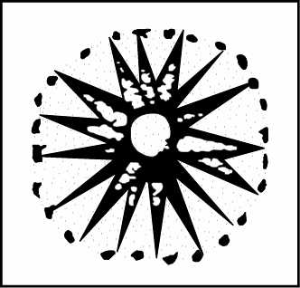
Figure 6
Research-Selection for NovoScriptorium: Isidoros Aggelos

Very interesting! Having been to Knossos I wish I would have known all this first!!
LikeLiked by 1 person
Thank you for this very interesting post. I’m very intrigued by the possible use of a magnetic compass in Minoan and Mycenaean times. You might be interested in a recent archaeological discovery in Mycenaean Pylos, which I covered in my latest post. There’s a depiction of a 16-point star on an artifact and your post immediately caught my attention because of it. Here’s a quote from my post: “An agate seal stone featured two lion-like creatures called genii standing upright on clawed feet. They carry a serving vase and an incense burner, a tribute for the altar before them featuring a sprouting sapling between horns of consecration, Stocker said. Above the genii is a 16-pointed star. The same 16-pointed star also appears on a bronze and gold artifact in the grave, she said. “It’s rare. There aren’t many 16-pointed stars in Mycenaean iconography. The fact that we have two objects with 16 points in two different media (agate and gold) is noteworthy,” Stocker said.
I tried to copy the image into this comment but it didn’t work. Please use this link if you’re interested: https://theshieldofachilles.net/2019/12/19/newsflash-uc-archaeologists-find-gold-lined-tombs-of-mycenaean-era-in-pylos-greece/
LikeLiked by 1 person
Dear Mrs Vail thank you very much for the information! Indeed we are interested in this! Excellent post!
LikeLiked by 1 person