
Drainages, meanders and mazes are part of the heritage of symbols and water practices of the Etruscan civilization which settled in central and southern Italy from pre-historic times to Roman antiquity. To permit agricultural activity in northern Latium and Tuscany, the soils were drained by means of moats, tunnels, dams and diversion systems similar to those realized in Boeotia in the second millennium to control the level of Lake Copaide.
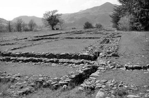
Etruscan archaeological site of Marzabotto
During the Early Iron Age (ca. 1100–950 BC), aqueducts, cisterns, and wells were built similarly to those constructed by the Minoans and Mycenaeans. Etruscan fortified cities such as Orvieto, Orte and Volterra had stairs carved into the rock, as well as cisterns and tunnels similar to those found in Mycenaean citadels. The technique of water drainage with underground tunnels may have been exported into Italy from the East in the 8th century by the Etruscans through Lydia.
Water Harvesting and Distribution Systems
Remains of the Etruscan water collection and distribution systems have been found in several Central Italian cities such as Perugia, Orvieto, Todi, and Marzabotto. The urban plan of an Etruscan city, perfectly organized in terms of both viability and discrete public and private spaces, was characterized by a complex and efficient water system consisting of channeling for rainwater, and cisterns and wells for the collection of spring water for private houses and public facilities, as well as a road network. The archaeological site in the city of Marzabotto, in the Province of Bologna, in Central Italy, is particularly interesting. The ancient site of Marzabotto was very well organized in terms of water collection and distribution and, evidenced a unique hydraulic system.
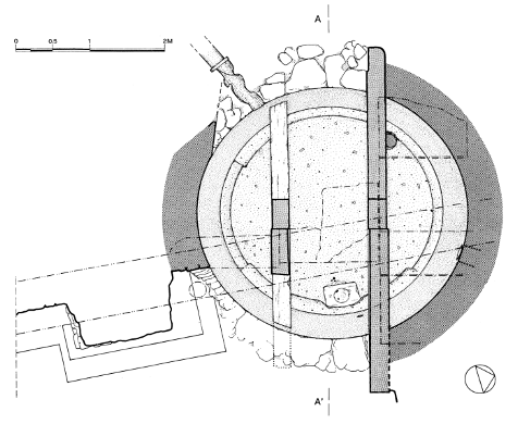
Plant of the cistern in Via Cesare Caporali, Perugia, central Italy
The structure was placed on the ground, not far from its original site. The plant, constructed of travertine blocks, consists of a partially-exposed central body of 1.80 × 1.20 m² (exterior) by 1.45 × 0.65 m² (interior), divided by a sort of diaphragm into two tanks of different levels. The overall height is approximately 0.50 m. Two upstream channels intercepted the water of superficial groundwater. The water entered in the first of the two tanks, a settling tank of 0.75 × 0.65 m² with a height of 0.50 m.
This tank could contain approximately 244 L of water. The impurities were deposited on the bottom of the first tank, while the clean water was channeled toward the underlying urban area by two travertine ducts. Both the outflow travertine channels consist of a double row of blocks with an interior opening measuring approximately 14 cm in diameter. The channels were directed towards two important workshops for the production of ceramics and bricks.
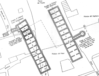
Tunnels and galleries, more than 30 cisterns, Etruscan, Roman and Medieval and about 500 wells of several ages in the city of Todi, Umbria
Cisterns
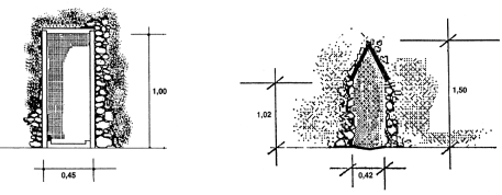
The city of Perugia, in Umbria, is full of ancient Etruscan wells and cisterns. They are related to each other on the basis of a path linked to the old street network based on orthogonal axes, connected to the main gates of the city. One of the most interesting cisterns is in Via Cesare Caporali, accidentally discovered in 1989 during renovations of a building. The cistern is 8 m under the level of the roof slab. The walls are constructed of stones and mortar, and coated with watertight plaster. The vertical wall featured a hole of about 6 × 10 cm² in order to intercept the groundwater.
Two terracotta channels are located at the top, almost diametrically opposite, for collecting and conveying rainwater into the cistern. The plan at the bottom of the cistern is in opus signinum. The top diameter is 3.64 m, while the bottom is 2.98 m. The bottom plane is inclined towards a collection sump consisting of a travertine block. The cover of the cistern consists of large travertine slabs partially resting on the edges of the reservoir as well as two beams parallel to the diameter of the mouth, which divide the cistern into three spaces. The cover structure behaves statically as a wooden structure, similar to that used for the Sorbello’s well, still present in Perugia and described below. In 1888, in Orvieto, in Umbria, the so-called Etruscan cistern of San Domenico was discovered. The cistern, which is well preserved, is covered with a layer of clay measuring 50 cm in depth. It has a cylindrical section slightly tapered towards the bottom, with a diameter greater than 2.90 m and a height of 5.10 m.
The lateral surface of the cistern is made from tufa, travertine and basalt. The floor consists of crushed tufa with an underlying thin layer of sand overlaid on a thick layer of clay that surrounds the entire structure. The cover is made from blocks of tufa. In the town of Todi, also in Umbria, there are about 5 km of hypogeum tunnels and galleries, more than 30 cisterns, dating from the Etruscan, Roman and medieval periods, and approximately 500 wells. Particularly interesting is the so-called forensic Etruscan cistern (“Cisterna Forense”). The cistern rests on a base of about 2 m in opus caementicium on which the perimeter walls and partitions between the nine adjoining rooms, all built in opus caementicium, are placed. The barrel vaults were constructed on the walls and partitions (all of opus caementicium) by means of wooden ribbing, following well tested Etruscan craftsmanship. Overall, the tank is about 37 m long and 8.1 m wide.
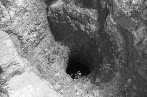
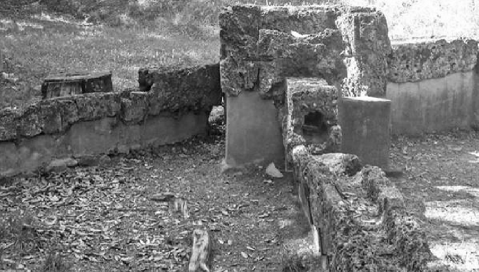
Well at the location Campetti, Etruscan City of Veio north of Rome
Groundwater and Wells
Etruscan wells for water supply were everywhere in the ancient urban area of Marzabotto: in practice almost each house had one well. The structure of the wells was based on a coating of pebbles. Shape and depth varied with static problems and soil characteristics and with depth of groundwater in the city’s plateau. The end part of each well, dug into impermeable marl, was used as a water storage tank in order to guarantee the availability of water even in times of drought when the water table was lowered to the boundary of river gravel. The well often had a gradual expansion in the soil until reaching the impermeable marl layer where the storage tank was constructed. The obliquity of the walls depended on the surrounding soil consistency as well as the wells depth. For instance, the cylindrical wells were generally the deepest. Ancient Perugia, as noted above, was rich in both wells and cisterns. The so-called “Pozzo Sorbello” (Sorbello’s Well), is considered the most important monument of the water supply system of Perugia. The well is located in the highest part of the city. It was dug in the conglomerate, reaching a depth of approximately 36 m from the road surface.
The cavity has a diameter of 5.6 m and a height of 12 m. In Piazza IV Novembre, in Perugia, next to the Fontana Maggiore (the most significant medieval monument for the city’s water supply), where the ancient forensic area is traditionally located, there is the so-called “Pozzo della Piazza” (Square’s Well). The diameter of the well varies between 3.2 and 3.5 m, it is more than 47 m deep and the top is covered with irregular pieces of travertine. At the foot of the forensic area, near Piazza F. Cavallotti, inside the building of the cathedral chapter, there is another well with a diameter of 1.2 m, it has only the upper part of the cane dug in the ground filling and is covered with irregular stones, while the section below is dug directly into the so-called “tassello”, a lacustrine conglomerate which constitutes the local bedrock.
In addition, the Etruscan town of Veio, a few kilometers away from Rome, was one of the most remarkable examples of diverse hydraulic works including groundwater wells. The town had a huge network of underground aqueducts, 50 km of which still remain, all realized between the ninth and the fifth century BC The aqueducts were used to monitor water capacity during floods, and to minutely and harmonically distribute water during droughts, through a complex system of flood-gates, tunnels, barrages, artificial lakes, and wells.
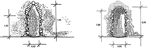
Sections of the “Fontana della Rua” tunnel in Todi, Umbria region
Drainage and Sewerage Systems
According to Sassatelli in ancient Marzabotto there featured a coordinated and comprehensive plan of the slopes of drainage channels on the sides of streets. The system was based both on the natural slope of the plateau and on an artificial modification aimed at taking into account the special needs associated with water runoff, such as the need to avoid one of the two necropoli located between the urban area and the river Reno, where wastewater was commonly discharged. De Marinis describes the drainage and discharge systems of the ancient Forcello, in the province of Mantova, in the Lombardy region, assuming the existence of two drains with the main function of town sewer as well as assuring drainage of the entire residential area. The city of Perugia is rich in drainage tunnels (the so-called “cuniculi”, plural, or “cuniculus”, singular). The tunnels are mostly dug into the natural conglomerate; only a few have been excavated in the fill soil. The cross section is elongated with an ogival vault; they are 1.7–1.8 m high and 0.7–0.8 m wide. The cuniculi of Perugia are similar to those of Orvieto and Todi. According to Piro most of the tunnels of Perugia had a drainage function. The tunnels were always placed in contact with conglomeratic and silt-sandy soils or within the thickness of the filling soil. This condition enabled good drainage efficacy. Moreover, draining water improved the geo-mechanical characteristics of the soil and provided more stable soil embankments. The cliff upon which Orvieto stands is composed of a thick layer of tufa alternating with layers of pozzolan. The erosive action of the atmosphere coupled with the anthropic activity shaped the cliffs, making it an impregnable fortress, and the site of an important Etruscan community. In the plateau, isolated on every side, there are more than 600 artificial cavities, in which many Etruscan remains have been found.
The city of Todi, in Umbria, is located on an isolated hill near the confluence of the Rio stream with the river Tiber. The wells of each Era in the historical center of Todi number more than five hundred, and the network of tunnels, dug at different altitudes, covers planimetrically almost the entire urban area. Bruschetti describes the tunnels of the great bastion system, the so-called “Etruscan bastion”. Behind the ramparts, there are several drainage channels. The main tunnel, located on the lower level, was the first constructed to drain water into the ditch. Other tunnels, at higher altitudes, but all converging to the first through a well, drain and convey spring waters and rainwater that otherwise would be dispersed throughout the fill, causing excessive pressure on the retaining wall structure. The tunnels have different sections: in all cases the walls are lined with blocks of limestone arranged in very regular horizontal rows, the bottom consists of travertine slabs or tiles, laid over filling soil. The upper portion of the tunnels are clad with slabs of travertine or with tiles placed to form a gabled roof. Bergamini describes the tunnel known as “Fontana della Rua” (Rua’s fountain). This complex of tunnels is arguably the most important of the city’s entire water network: it is the longest (about 350 m), has a significant water regime, is in excellent condition and has a variety of building types that denote its continued use over time.
Sections of the “Fontana della Rua” tunnel in Todi, Umbria region
The idea of an urban management system provided the platform upon which the federal system of the “Dodecapolis”, the twelve lucumoniae in the Etruscan region, was developed. The federal system encouraged reciprocal (financial, commercial and cultural) growth of cities and increased the wellness, richness and stability of the citizens.
The Etruscans developed a rational planning of urban areas with a clear distinction between public and private spaces with specific water systems supplying workshops.
The Etruscans exhibited their engineering skills (hydraulic, structural and geotechnical) in the construction of cisterns. Particularly, the Etruscan systems featured statical behavior with a wooden structure, the use of barrel vaults, and wooden ribbing.
Wells for water supply were ubiquitous in ancient Etruscan urban areas: often the termini were used as a water storage tank in order to guarantee the availability of water even in times of water scarcity.
The drainage and sewerage systems developed by the Etruscans were based on an advanced planning of the slopes of drainage channels on the sides of streets as well as a massive use of drainage tunnels.
(Source: “Minoan and Etruscan Hydro-Technologies”, by Andreas N. Angelakis et al.)
Etruscan archaeological site of Marzabotto
Research-Selection for NovoScriptorium: Philaretus Homerides
