
Here we present selected parts of the paper titled “Geological Knowledge of Greeks in the Era of Trojan War“, by Professor emeritus of Geology Ilias D. Mariolakos, taken from the impressive collective work “Science and Technology in Homeric Epics“, edited by S.A. Paipetis (Springer, 2008).

Abstract Among the many important historical, cultural and geographical elements found in the two Homeric epics, Iliad and Odyssey, there are many that allow the present-day geoscientist to draw indirect conclusions about the geological knowledge of the inhabitants of the Aegean and Circum-Aegean region.
By the end of 19th century, K. Zeggelis, published a monograph, entitled The Science of Naturein Homer (1891), where, among others, he mentioned and commented on the poet’s references on minerals (metals and non-metals), their origin and the metallurgical knowledge of the people of that era. The opinion of Zeggelis that the metallurgical processes used, although known at the time of Homer, were not performed in Greece, but in other (probably Oriental) countries has been rejected by the newest archaeological and archaeometric studies, showing that metallurgy and smelting had begun in Greece long before the Trojan war, even before the Mycenaean times.
In this paper, we shall refer to the indirect conclusions to be drawn by the modern geoscientist, regarding the technical knowledge of the prehistoric Greeks, by studying drainage — anti-flooding works and dams constructed in Arcadia, during the Mycenaean times.
Arcadia was chosen because, as mentioned, the Arcadian king Agapeinor, son of Lycurgus, who lived in the town of Tegea, lead 6,000 Arcadians against Troy. The army was carried on 60 ships, offered by Agamemnon.
In the greater area of the Arcadian Plateau, a series of basins constitute a geologically “composite” polje. These basins are: the Takka basin, the Mantineia basin, the Argon Field (Nestani plain), the Levidion — Ancient Orchomenus basin and, finally, the Kandela basin. In three out of these five basins, the prehistoric people of Minyans had constructed a series of earth dams and other drainage works, as mentioned by Pausanias. These works were studied in great detail by J. Knauss, Professor of Hydraulic Engineering in Munich Polytechnic School.
(i) protecting great parts of the basins against flood waters coming from the surrounding moun tains and the many karstic springs of the areas, thus increasing the land suitable for cultivation (land reclamation);
(ii) securing irrigation water; and
(iii) draining the many small swamps formed in the various plains, thus reducing the risk of malaria.
-
the meteorological and climatic conditions of an area,
-
the river-yields and their sediment load,
-
the topography,
-
the physical and mechanical characteristics of soils,
-
the geology of the flood basin and of the greater area, as well as the hydrogeological characteristics of the alpine and post-alpine geological formations,
-
the karstification and the hydraulic behavior of the karstic forms (caves, sinkholes, karstic springs, etc.),
-
and many more.

Introduction Among the many important historical, cultural and geographical elements found in the two Homeric epics, Iliad and Odyssey, there are many that allow the present-day geoscientist, to draw indirect conclusions about the geological knowledge of the inhabitants of the Aegean and Circum-Aegean region.
In this paper, we shall refer to the indirect conclusions to be drawn by the modern geoscientist, regarding the technical knowledge of the prehistoric Greeks, by studying the drainage – anti-flooding works and dams constructed in Arcadia, during the Mycenaean times.
It is known that Poseidon is not only the God of the Sea, but also master of the geological phenomena and processes occurring both in the interior of the lithosphere and on Earth’s surface. Therefore, vertical movements, earthquakes, fluvial processes, all the physicogeological processes in general, which are known in Geology as “endogenous” and “exogenous” forces, are controlled by Poseidon. It is said that Poseidon, along with Apollo, having the intention of destroying the walls of the Greeks, “engineered” the change of the position of many river channels, as well as river flooding, the Scamandros River included. It is also said that after the flooding the beach became level and the flood water withdrew to their normal river channels. Homer refers to another case in which the Scamandros overflowed its banks. This flood was also caused by Poseidon, in his unsuccessful effort to sidetrack Achilles.

The Minyans The native land of the Minyans is considered to be either Thessaly or the greater area of Orchomenus, mainly Lake Copais (Boeotia). The Minyans are considered to belong to the Pelasgians, whereas Ploutarch associates them with the Leleges. They are also regarded to be Thracians or Aeolians. However, little is known about this Pelasgian tribe.
The Argonauts were also called Minyans, because either most of them were sons of the daughters of Minyas or Jason, the ruler of Argos and the leader of the Argonauts and the expedition, belonged to the Minyans. It is also argued that all the inhabitants of Iolcus were called Minyans.
Minyas was king of Orchomenus city, where is located his Tholos tomb, known as the Treasury of Minyas. Minyas was very rich and it is said that he used to store his riches in underground galleries-stores.

The galleries in which Minyas stored his riches might have been natural or artificial. The natural ones were a multitude of caves lying in the margins and the mountains surrounding Copais. These mountains consist of intensely karstified carbonate rocks. As regards the artificial galleries, the Minyans have shown that they knew how to construct excellently, from an engineering point of view, underground galleries, like the one located north of the present-day settlement of Neo Kokkino.
Part of the floodwater was conducted to the Euboean Gulf through this underground gallery, whereas the rest of it was conducted through the cave – sinkhole lying at the present-day settlement of Neo Kokkino, known as “the cave of Hercules”. Remains of the great engineering structures constructed by the Minyans are found in nearly all of the basins of Greece.

Works Constructed by the Minyans in the Greek Region Since Pausanias’ time, it has been known that in prehistoric times many and great geotechnical works were constructed in various lowlands of the Greek mainland, such as in Thessaly, Boeotia, Argolis, etc.
These works aimed at:
(i) protecting great parts of the basins against flood waters coming from the surrounding mountains and the numerous karstic springs of the area, increasing thus the land suitable for cultivation (land reclamation).
(ii) securing irrigation water, and
(iii) draining the numerous small swamps formed in the various plains, thus reducing the risk of malaria.
All of these works have been studied in detail by Knauss, who has devoted all of his research activities to these studies for the last 30 years.
The detailed study of the works by J. Knauss, from a hydraulic engineer’s point of view, show that the Minyans were not only skilled engineers, but that they also had excellent experience and knowledge on construction-site management, project management (very similar to the knowledge of modern engineers), and also that they were capable of “diplomatic” interventions between cities, etc.

The site and the remains of these works are described by Pausanias, and many of them have been located by the contemporary archaeological research. Of course, some works are not mentioned by the traveler, probably because they have been destroyed. The greatest and best preserved anti-flooding work is the great drainage ditch in Copais, which was used to drain Lake Copais (Boeotia).
The Minyans constructed many geotechnical works, such as earth dams, draining ditches, river diversion works, taping of sinkholes etc. The most known of these land reclamation works are a dam at Taka, the drainage works close to the basin of ancient Orchomenus – Kafies, the anti-flooding works in the Kandela plain, in the Feneos plain and in Stymphalia. There are probably other works, not known to the public yet, such as Mantineia dam, which was unknown until quite recently. Similar works were constructed in Argolis, in particular at Mycenae, Tiryns and in the greater area of the Lerni springs.

Mantineia Dam In the area lying south of ancient Mantineia, the Minyans constructed a dam that retained the water coming from the south. In this way, a reservoir was formed, which, as Knauss estimated, could retain a volume of water as large as 15 million cubic meters.
This dam, like all Mycenaean dams, was an embankment 3 m high, with a totally impervious clay core surrounded by additional clay material. It was covered by processed boulders, placed in such a way that it would have been protected from erosion. This earth dam was constructed at a narrow site in a long and narrow valley lying NE of city of Tripolis, in the flat lowland lying in front of the foot of the hill, where the present day settlement of Skopi is situated.
The Minyans knew the behaviour of the karstic formations very well. This is inferred from the great works that they constructed to drain Copais Lake, where there are many karstic formations. Therefore, given that the conditions in the reservoir basin in the era of the Minyans had been the same as today, the dam would have served only the purpose of controlling floodwater, since it would have been impossible to hold the water leaking through the sinkhole. No matter whether or not the Minyans managed to form the reservoir, the dam prevented floodwater of Sanovista stream, known as Lahas in ancient times, from flooding Mantineia lowland.
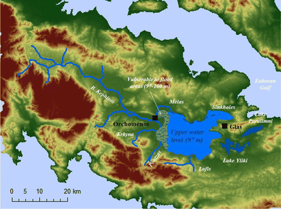
The Drainage Trench at Orchomenus Between the Upper Orchomenus Plain, known as the Levidion Plain, and the Lower Plain, which stretches between settlements Kandyla, Kafies and Hotousa sinkhole, the Minyans, in early Mycenaean era, maybe earlier than 3rd millennium BC, excavated an artificial ditch characterized by Pausanias as “trench”, through which they managed to drain the Upper Field, conducting the floodwater to the Lower Field.
The eastern edges of this artificial “gully”, whose width varies between 5.5 and 6.5 m, have been excavated in formations of the Olonos-Pindos geotectonic unit. Some portions of it coincide with a fault surface. At its western edges, a wall, about 2 m wide and a remaining part 1–1.5 m high, has been constructed. According to Knauss, the construction remaining in the central part of the valley may actually constitute the remains of a watermill, either of the Mycenaean period or later.

In the Lower Plain, also known as the Kafies Plain, the Minyans constructed a reservoir. In this reservoir the water coming from the Orchomenus Plain, the surrounding mountains and the Kandela Springs was gathered. The reservoir was formed behind of a dam constructed at the NW narrow site of the valley. Pausanias characterized this narrow site as “earth’s soil”. Also, there was a smaller embankment at the eastern part, and the overflow of water was conducted to the great Hotousa sinkhole. In this way they achieved many goals, such as:
(i) Drainage of the Orchomenus basin (Upper Field).
(ii) Partial drainage of a great part of Kafies basin (Lower Field).
(iii) Reclamation of the drained areas for agricultural purposes.
(iv) Adequacy of water for irrigation purposes in summer.
(v) Cleansing of the swamps, thus reduced malaria risk.

Technological Knowledge of Minyans The systematic and in-depth study of the works, not only from a geotechnical point of view, but also from the aspect of the purpose of construction, raises a series of questions about the Minyans.
A detailed study of the greater area of the Arcadian Plateau was performed, before the final decision. This study, e.g. of a dam, should consist of three basic parts:
(i) a detailed study of the topography,
(ii) a hydrological study, and
(iii) a geological-hydrogeological study.
The study of topography is absolutely essential, since engineers/planners must know the dimensions of the dam, i.e. width, height and mainly length. Furthermore, it is essential, since engineers must know the extent of the reservoir basin, as well as height and position of spillway, so that, if the quantity of floodwater exceeds storage capacity of the reservoir, conduct floodwater out of the reservoir, preventing overflowing the top of the dam, which may destroy the dam and cause disastrous flood downstream.
A detailed hydrological study is essential, since planners must know the quantity of water flowing into the reservoir basin and the elevation, to which water will rise, particularly with earth dams. The quantity of water to be stored in the reservoir can be calculated in detail, provided that the following are known:
(i) The surface area of the drainage basin, i.e. of the river basin collecting and funnelling water to the reservoir.
(ii) The distribution of precipitation in space and time, i.e. distribution of rain and snow with elevation during the year, flood discharge, and many more. To appreciate the importance of this, it should be mentioned that, at present days, although there is a network of meteorological stations in Arcadia, a detailed hydrological study for the construction of a dam cannot be performed, as the number of the stations is not enough.
(iii) The geological structure and the rocks, constituting the foundation of the dam, as well permeability of rocks of the reservoir must also be known. This is essential, since, if the rocks of the floor were permeable, the water stored would leak and the dam itself would encounter many problems, possibly disastrous.
(iv) Special soil-rock materials are required for the construction of an earth dam. Not all soils are suitable. Locating these suitable soils is not always feasible and special knowledge and experience is required. Nowadays, this job is carried out by experts in soil mechanics and engineering geology, and the samples collected are tested in special soil mechanics laboratories.
(v) Dam construction is such a difficult and elaborate job, requiring special theoretical knowledge and lots of experience. Of course, the dams of the Minyans were not higher than 3 to 4 m. However, even those dams required special study and the same level of knowledge, since the elevation of the water level in the reservoir was much higher than the ground surface downstream. Thus, the dam had to be waterproof. This is accomplished by applying a special technique, e.g. soil compaction. Nowadays, compaction is carried out by placing the soil in layers of a specific thickness, next it is wetted with quantities of water according to its grain size distribution, and, finally, it is tamped.
All of the above have been mentioned to make clear that the Minyans, in those ancient times, had a wealth of knowledge, on which these unprecedented engineering structures, preserved for at least 3,500 years, were based. The fact that the many kilometres-long earth dam or embankment, on which an important road of province road network was founded, i.e. the road connecting Kastro village at Copais with Orchomenus, has not exhibited any problems due to consolidations, means that this work is technically flawless. As far as I know, there are no public works having operated and been preserved for 3,500 years, as the embankment on Melanas River, on the northern margin of the Copais basin (Boeotia).

Economic and Managerial Capacities of the Minyans Apart from an official decision, dam construction requires not only scientific and engineering knowledge, but also funds and manpower: The cost was enormous, even by present-day standards. Who financed these works? What did the Minyans get in exchange? Who worked for their construction? Were they slaves or free people? In addition, they had to manage a construction site.
And the great question is, where and when did Minyans learn all these things? Is mere experience sufficient? Would the implementation of a project of such a scale have been possible, without even a rudimentary plan? Such questions have neither been raised nor studied, i.e. they have not yet been considered by the scientific community, and, as a result, are still unknown. I believe that we would get conscious of the way that ancient Greek civilization reached this level, only if we study the works of the Minyans systematically.

Why did the Minyans not construct such dams in Argolis? In my opinion, the reason is that, from a hydraulic and engineering geological point of view, the area of Argos is not suitable for the construction of dams, since all the river systems have torrential flow and high sediment discharge. Of course, a dam could have been constructed on Erasinos River, fed by the water of Kefalari springs; consequently, it does not have torrential flow and its sediment discharge is zero. However, along the channel of Erasinos no sites suitable for the construction of a dam and the filling of a reservoir exist, except for the plane entrance area.
According to J. Knauss, a great embankment has been constructed there, mainly an anti-flooding work, least used for irrigation purposes, since the elevation is low. In addition, since sea level in the Argolic Plane in Mycenaean times was around 1–1.5 higher, it is clear that the reservoir could not be used for irrigation purposes.
Thus, although in the Argolic Plain, climatic conditions, mainly temperature, are favourable for agriculture, no systematically cultivation can take place due to water shortage, e.g. in summer. However, this is not a big problem for the cultivation of cereals: Basic species, such as cereals (wheat, oats, barley), olive and vineyard, not requiring irrigation, could be cultivated.

Research-Selection for NovoScriptorium: Philaretus Homerides

So interesting! Thank you!
LikeLiked by 1 person