
Throughout human history in the eastern Mediterranean region, urban settlements have co-existed with earthquakes. The destructive capability of seismic activity is well chronicled by historians, and its cultural wreckage widely uncovered by archaeologists. Accounts and observations of seismic damage to ancient constructions and relics offer partial information on the size, location and date of ancient earthquakes. Buildings and structures damaged by shaking or offset across faults provide archaeological markers that can shed light on the slip history of possible seismogenic sources and can inform regional seismic hazard.
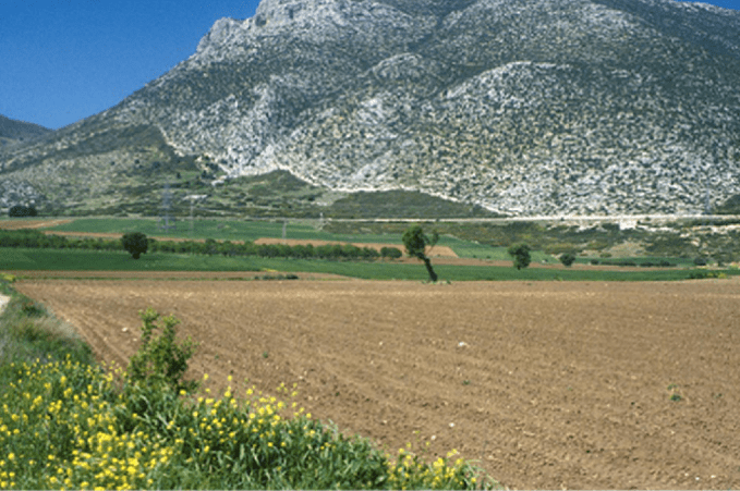
Figure 1
Any tendency for active faults to disrupt former urban settlements might seem to be an unfortunate situation that arose spuriously as a consequence of past populations, ignorant of seismic threats, being unwarily drawn to these invisible axes of destruction. The lure of these lethal corridors of land reflected the surprising advantages that tectonically active belts offer; active faults can create and sustain attractive conditions for human development, sustaining dynamic landscapes in which recent tectonics ‘frame’ patterns of human land use. Groundwater leakage and sediment build up along young fault lines provide well-watered corridors of land, leading some to conjecture that active tectonic zones seeded the earliest centres of Neolithic agriculture and even of early civilisations. Moreover, the tendency for active fault lines to provide persistent groundwater egress and fertile land over millennia lies at the root of the ‘fatal attraction’ that today finds many populous towns and cities across the eastern Mediterranean and Near East lying directly above seismically dangerous faults.
An association between active faults and ancient places is examined here in the context of some of the most prominent sites of Greek antiquity. A close correspondence of active faults and ancient cities here is not unduly surprising – the Aegean region is riddled with seismic faults and littered with ruined settlements, so some casual correlation is to be expected. But the correlation is more than simply a contiguous association – across central Greece and western Turkey many seismic fault traces do not simply disrupt the palaeo-urban fabric of buildings and streets but rather they penetrate into the heart of ancient settlements to break or disrupt important sacred structures.
Scarps and springs: the example of Mycenae
In the Aegean sector of the Mediterranean, active normal faulting operates within a largely carbonate-dominated karstic landscape. Repeated vertical fault movements form limestone scarps, which in the physical landscape separate the rocky karstic uplands from the soil-rich plains (Fig. 1). These abrupt linear bluffs – metres to several tens of metres high and fronted by smooth surfaces polished by repeated seismic slip – serve as natural ramparts on which fortifications, citadels and acropoli were constructed. In addition to forming advantageous topographic positions, across the limestone terrain of Greece and western Turkey, copious and persistent cold and hot mineral springs preferentially emerge along active faults. In turn, because the waters harvested from them not only supplied a range of early water management practices but were also essential for purifactory or therapeutic purposes, it has been argued that early Greek settlements were purposefully centred on natural fountains and springs.
An instructive example of the strategic benefits accrued from living on an active fault is found at Mycenae, in the eastern Peloponnese region of mainland Greece. The famed Mycenean hillltop citadel is bounded by metre-high limestone fault scarps on its southwestern and northeastern sides, and its formidable ‘Cyclopean Walls’ partly built on top (Fig. 2). The southwestern scarp is the more obvious, bordering the famed Lion’s Gate entrance. The longer and more continuous northeastern strand, however, is arguably the more significant structure because it hosts the ‘Sacred Spring’, one that although located just outside the citadel could be accessed from within the city walls via a subterranean passageway that tapped the fault zone. Maroukian et al. (1993) argue that it is this fault that ruptured during Mycenean times causing widespread destruction of the citadel, a reminder that the strategic advantage of living atop an active fault could be negated by the ruinous effects of seismic reactivation directly below.
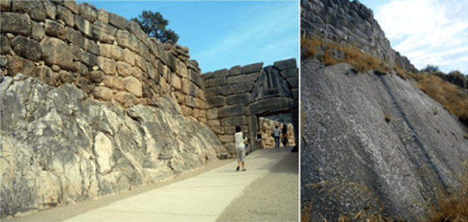
Figure 2
Earthquake hydrology and the curious case of Perachora Heraion
If natural springs are important for the functioning of Greek settlements then the loss of reliable groundwater sources might equally be a cause for the abandonment of those same sites. Large earthquakes are known to cause significant reorganisation of the pattern and rate of groundwater flow. Such abrupt changes to groundwater can be transient and quickly recovered, but occasionally earthquakes cause the permanent termination of persistent springs and provoke new springs to burst forth elsewhere. Finding archaeological evidence for settlements whose springs were lost to ancient earthquakes is difficult, but a possible candidate lies at the eastern end of the Gulf of Corinth, at Perachora Heraion.
The ruined Classical Greek sanctuary of Perachora Heraion occupies the westernmost tip of the Perachora Peninsula, a fault-bounded promontory projecting into the eastern Gulf of Corinth. The sanctuary – a temple complex for the goddess Hera initiated around the 9th century BC – is an enigmatic Classical site. It was largely unknown prior to its excavation in the 1930s by the British archaeologist Humphry Payne, yet surprised all with a wealth of votives surpassed only by the famed Greek sanctuaries of Olympia, Delphi and the Athenian Acropolis.
The site’s curious importance in antiquity has been attributed to its strategic position overlooking the dangerous maritime waters of the Gulf, although Strabo in the late 1st century BC reported that it also had been an oracular sanctuary ‘in early times’. That sanctuary had been highly frequented by the nearby Corinthians throughout the Archaic period, but subsequently fell into disuse around 300 BC. Although votive relics excavated from the temple by Payne (1940) confirmed its oracular status, it is uncertain how the oracle functioned. The most recent analysis identified a small, entirely walled room in the centre of the northern wall of the Hera Akraia temple as the most likely location of an oracular chamber. In that location, the chamber directly abuts a prominent active fault.
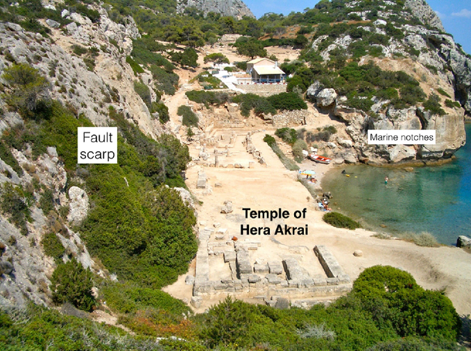
Figure 3
The steep E–W striking, S-dipping normal fault scarp forms the sheer backwall of the archaeological sanctuary (Fig. 3). The smooth limestone fault plane is etched by fine frictional striations, consistent with recent seismic slip. The scarp is part of a network of fault strands that coalesce eastwards into the South Alkonides Fault Zone, a structure that ruptured in the 1981 Gulf of Corinth earthquake sequence, when two M 6 shocks produced metre-scale surface breaks east of Perachora village and created a corridor of ground fissuring west towards Heraion. Although no discernible surface ruptures occurred at the archaeological site, there is geological evidence that the Heraion fault scarp has ruptured in recent millenia. The evidence comes from a series of marine notches cut into the limestone sea cliffs at Heraion, which record episodic late Holocene tectonic uplift of the headland. The highest and best defined notch level, dated at around 6.4 kyr BP, occurs at an elevation of +3.2 m above sea level in the sea cliff to the west of the harbour, but occurs at +2 m within the harbour. The Heraion Fault separates the two, with the higher notch level cut into the uplifted footwall of the fault, indicating a 1.2 m vertical offset of this mid-Holocene marker and implying relative movement across the fault during the last few millenia.

Figure 4
There is also archaeological evidence for recent movement on the Heraion fault. The original site excavation – whilst not recognising the steep scarp as a fault plane – detected the effects of seismic disturbance in the 6th century BC temple, Hera Akraia (Fig. 4). According to Payne (1940), the northern wall of the temple of Hera Akraia is dislocated by a few tens of centimetres . . .
“ . . . because the western part of the building has slipped down to the south in the course of an earthquake. The easternmost stones of the western section have been tilted up by an earthquake and the whole eastern part, none of which is bedded on rock, may well have shifted slightly”.
The geological and archaeological evidence suggests that the fault at Heraion experienced at least one seismic rupture in antiquity, but the extent to which the functioning of the settlement was fault-related is uncertain. There are no active springs at the site today – the western end of the peninsula is essentially waterless – though at Loutraki a few kilometres east the oldest Greek thermal springs lies on the prominent Loutraki Fault. Moreover, much of the Heraion temple complex is constructed on late Pleistocene bioherms that attest to a prolific expulsion of carbonate-rich waters, indicating that the faulted headland is a former site of persistent CO2 degassing from submarine springs. Although it remains entirely speculative, a viable alternative scenario for the demise of Perachora Heraion is of a fault-related oracular sanctuary abandoned as a result of a damaging seismic rupture disrupted the site, but more critically, permanently closed the groundwater springs that had secured its special status.
The sacred status of seismic faults: Ephesus and Cnidus
The rich mythology of water management practices in the Aegean karstlands supports the view that groundwater patterns may have influenced the founding and functioning of Greek cities in antiquity. Ephesus in western Turkey, for example, is widely held to have been established on the site of the famed Hypelaeus spring, which Scherrer (2000) identifies with a source rising from a crevice in a limestone knoll located in the 8th century BC Ionian enclave to the north of the more extensive Roman city. Used as a sacred well from the Archaic period, the source was covered with a small shrine called the ‘Crevice Temple’, possibly a Temple of Athena, in the late Classical or early Hellenistic period. One of the earliest buildings in the original Greek settlement, it is believed to have served as an Apolline oracular sanctuary. Certainly the deep cleft is central to the temple plan—the crevice fissure does not offset the temple walls or floor, indicating that that the fissure was already there when the temple was hewn out of the bedrock (Fig. 5a).
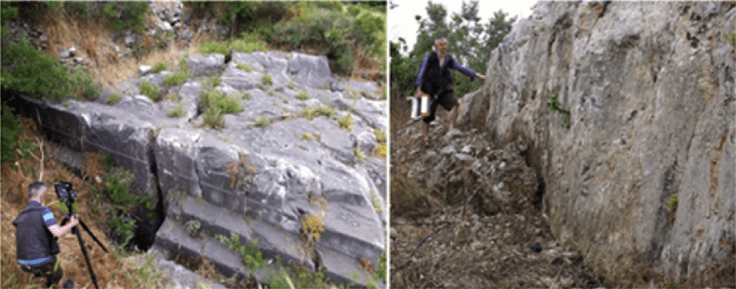
Figure 5a Figure 5b
Although no faults displace the Crevice Temple, the northern edge of the sacred enclosure is bounded by a prominent limestone fault scarp (Fig. 5b). To the east, a similar scarp displays numerous upright, rectangular flat niches chiselled into the smooth rock face (Fig. 6). These niches housed votive reliefs – the oldest of which date back to the 5th century BC – that reflect an important sanctuary, one which was at the peak of its renown in the late Classical-early Hellenistic period.

Figure 6
In the former Greco-Roman city of Cnidus, south-west Turkey, where a spectacular near-vertical fault surface forms the dramatic backwall to a sacred enclosure, rock-cut votive niches carved into the exhumed fault plane were interpreted by the archaeologist Charles Newton as signposts for a buried mid-4th century BC temple complex below (Fig. 7). Only sections of the enclosure’s massive masonry retaining walls remained.
Close to the fault scarp these walls are strongly tilted and bent, and excavation revealed that “ . . . in one place near the centre of the escarp the strata of soil were curiously contorted, and among them was a layer of ashes, lamps and other human remains” (Newton, 1863), consistent with the description of a palaeoseismic ground rupture.
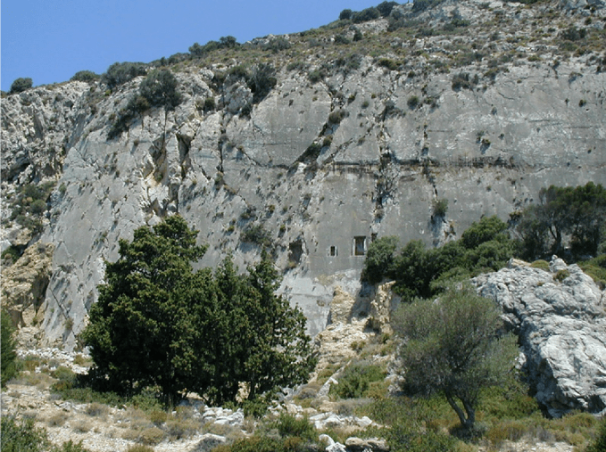
Figure 7
Faults as connections to the underworld: Delphi and Hierapolis
It is an intriguing possibility that as physical conduits to the subsurface, faults themselves may have been regarded as direct connections to underworld—the chthonic realm. The geological aspects of the various gateways to the mythical underworld are reviewed elsewhere but here the key attributes of the two most prominent chthonic sanctuaries of Greek antiquity are summarized. Those sites are Delphi and Hierapolis.
Delphi
For almost two thousand years Delphi was venerated as the principal oracular centre in the Aegean world. Here, ecstatic prophesy was achieved by a priestess who first purified herself by bathing in a sacred spring and then inhaled intoxicating vapours rising from groundwater issuing out of a natural chasm in the rock. De Boer et al. (2001) proposed that the inhalation of the sweet-smelling ethylene, a mild narcotic, could be the reason for the mantic trance of the Pythia, while Etiope et al. (2006) speculated that if any gas-linked neurotoxic effect of the Pythia existed it could be related to oxygen depletion due to CO2-CH4 exhalation in the non-aerated inner sanctum (“adyton”). Geochemical studies disagree about the leakage of intoxicating gases from natural springs at Delphi (cf. de Boer et al., 2001; Spiller et al., 2002; Etiope et al., 2006), but Piccardi et al. (2008) contend that ‘ . . . the mythological gas-exhaling chasm can plausibly be related to episodic seismic ruptures in the ancient past, which affected for a limited time gas pockets fed by a relatively deep confined hydrothermal system.’
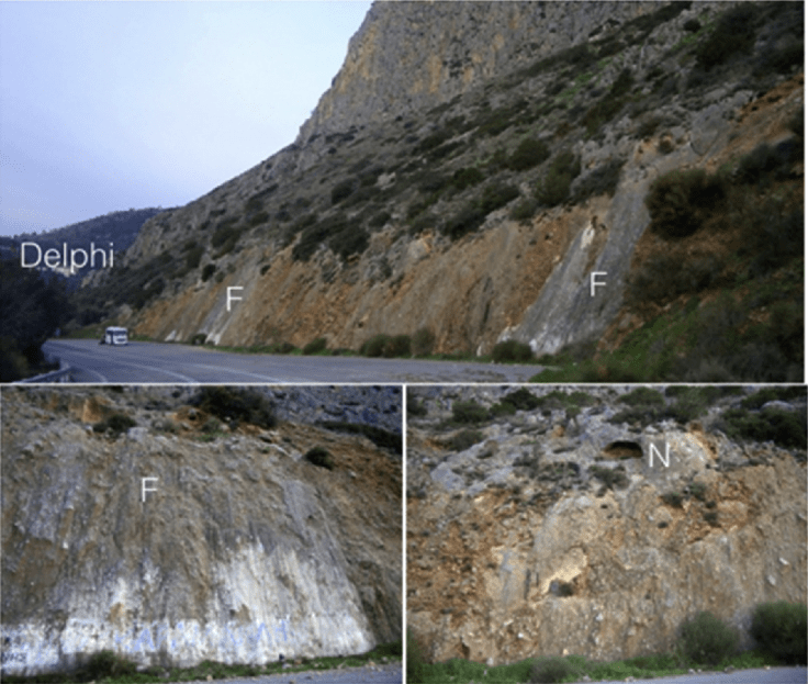
Figure 8
Certainly the environs of Delphi are fault-controlled. The site occupies a distinct step-over in the trace of a major E–W trending active normal fault zone, which forms a spectacular limestone fault escarpment at the foot of which are bedrock fault scarps and polished slip planes (Fig. 8a – top). In places, these fault surfaces exhibit rock-cut niches, although the function and significance of these is unclear (Fig. 8b – down left and 8c – down right). Within the site itself, two separate areas are considered to be affected by faults. The first is on a lower terrace where the original (Mycenean: 14th century BC) sanctuary was dedicated first to Ge, the female deity of Earth, and subsequently converted to Athena. The second is on an upper terrace where the more extensive sanctuary of Apollo was founded in the 8th century BC.
In the lower sanctuary, a recent splay from the main bedrock fault scarp cuts through the oldest temples and altars inside the shrine of Athena, faulting the archaeological relics therein. It is likely that much of this damage occurred in the earthquake of 373 BC, which caused widespread destruction at Delphi and which necessitated the reconstruction of the sanctuary; the new temple of Athena was relocated a few tens of metres further west but still directly straddling the fault trace (Fig. 9).
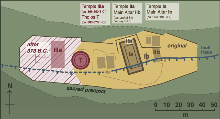
Figure 9
Conventionally, archaeological sources place Delphi’s oracular centrepiece – the site of the basement chamber (adyton) and the natural chasm – beneath the Temple of Apollo on the upper terrace. The higher sanctuary itself is cut by several NW–SE trending subsidiary faults, inferred mainly from spring lines, and one of these is taken to pass through the Temple of Apollo. Signs of this can be seen in the warping of its inner walls, which are markedly bent at its intersection with the proposed trace of the cross-fault (Fig. 10). This deformation is consistent with a minor (tens of cm) lateral shift on an underlying fault – either by gravitational slippage of the steep fractured terrain on which the sanctuary rests or by minor faulting – supporting the view of de Boer and colleagues that the adyton in which the oracular divination took place was above a discrete slip surface, directly below the temple.
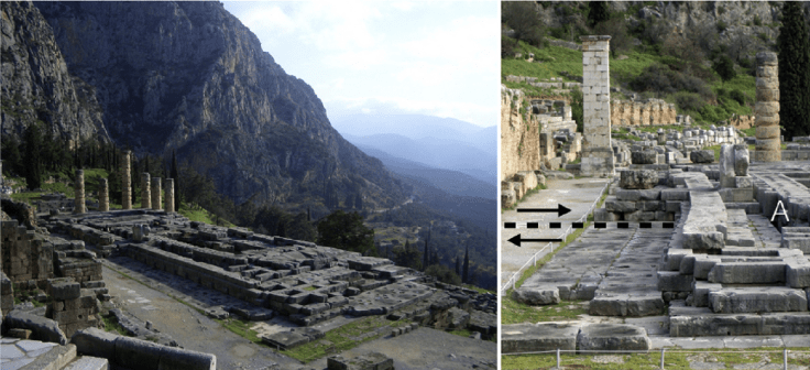
Figure 10
Hierapolis
Ancient Hierapolis in the Denizli region of western Turkey was founded as a Greek colony at the end of the 3rd century BC on the site of the Charonion—a natural source of toxic vapour famed for prophetic qualities. Carbonate-rich thermal waters cascading out from the Hierapolis Fault form travertine plateau that is today the famed world-heritage site of Pamukkale. The Greek city was destroyed and rebuilt after the ‘Neronian’ earthquake in 60 AD, and subsequently levelled again after an earthquake in Byzantine times, the line of which can be traced along the main street of the Roman city as a corridor of offset buildings and toppled walls. Along this seismic trace are a chain of hot mineral springs, and the opening of a hot spring in a fresh ground fissure formed during an earthquake in 1965 highlights how the springs are directly fed from the fault zone.
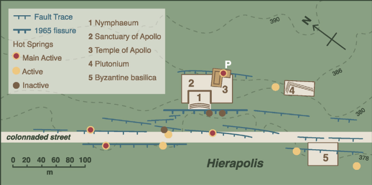
Figure 11
Built directly upon a strand of the Hierapolis Fault is the Temple of Apollo, the sanctuary of the Gods of the underworld, Hades and Kore. Historical sources recount how temple priests demonstrated their supernatural power and their equality to the gods by ushering animals into a basement chamber (Plutonium) where, after a few minutes, the creatures asphyxiated. In 1963, Italian archaeological excavations beneath the Apollo temple found an inner chamber with a natural chasm in the limestone floor, as well as inscriptions confirming it was a seat of oracular activity. Very high levels of CO2 concentrations in the chamber meant that for safety reasons it became almost completely sealed. That both the temple and the associated chamber are cut by multiple strands of the Hierapolis fault is clear from topographic profiles (Fig. 11), and geophysical imaging confirms that one of these fault splays passes directly beneath the chamber itself. From these observations Piccardi (2007, p.103) concluded that, as at Delphi, the main cult-site at Hierapolis was deliberately directly above the active fault, making it ‘ . . . likely that, together with the natural gas emission from the fault inside the Plutonium, the fault itself was venerated and regarded as a material opening to the underworld.’
Unsurprisingly, this toxic chamber was widely interpreted as the famed Plutonium and it is marked as such in touristic guides. However, recent excavations (2011–2015) have uncovered the real Plutonium immediately south of the Apollo Sanctuary, in the form of a hidden grotto dedicated to Pluto and Kore (D’Andria, 2013, 2016) (Fig. 12).
‘Gas measurements inside the closed subterranean chamber revealed CO2 concentrations of up to 91%. The entire basement of the grotto was totally dark but seemed to be highly humid, due to a warm, carbonate-rich creek flowing below it. Deadly CO2 gas also exists in front of the actual grotto. Flooding out of the grotto’s mouth, the escaping CO2 forms a gas lake on the floor. The corpses of animals hint at the absence of oxygen and the presence of high CO2 that builds up during the night.’ (Pfanz et al., 2014, p. 111).
D’Andria (2016) reports that in the grotto there is a large crack caused by the seismic fault, which is filled with votive offerings to a female divinity linked to the natural world and powerful subsurface forces (Cybele and later Persephone). The new excavations strengthen the fault-related nature of the oracular sanctuary and its chthonic character, meaning that at Hierapolis two separate constructions appear to have been positioned purposefully on the same active fault trace.
Concluding remarks and wider cultural implications
Earthquake faulting is endemic to the Aegean world, present and past. The physical expressions of seismogenic faults are a prominent and distinctive part of the physical landscape, providing the bluffs for citadels and fortifications and the egress for subterranean springs. The tendency for deep-seated fault zones to be conduits for gas-infused groundwaters to move up from mantle depths provides a viable geological basis for the sacred landscape of Greek antiquity. Water was at the heart of many ritual practices and some persistent spring sources were the hubs of enduring settlements (Crouch, 1993), with the most revered being those whose mineral waters released euphoric, hallucinigenic or lethal vapours. In places, such fumes pooled in clefts and chasms along the fault lines or in natural caverns and grottoes, and artificial chambers were constructed in temple basements to concentrate their effects. The flow of prophetic vapours fluctuated with time, and Ustinova (2009a, 2009b) has proposed that at Delphi ‘earthquakes could have been responsible for periods of renewed release of hydrocarbon gases’, as well as for ‘silencing springs’ and ‘closing fissures’. In such circumstances, it might be expected that sanctuaries that relied on sacred springs for rituals and prophetic activities might cease to be revered when disrupting earthquakes struck.
The contention that notable temple complexes appear to have been purposefully positioned astride active fault traces raises the question about whether the faults themselves were venerated as natural passageways between the ‘Upper’ and ‘Lower’ worlds. Certainly the seismic terrain of Aegean antiquity is the backdrop to ancient tales of individuals who attained oracular status by descending into the subsurface or who dwelled in subterranean abodes. Trophonius, for example, vanished beneath a hill in Lebaeia (Boeotia) and subsequently lived in a cave, being widely consulted as an oracular god; those seeking divine consultation descended into a grotto and drank from natural springs. Another famous seer, Amphiaraus, was believed to have been swallowed up by a natural chasm as he fled from Thebes (modern Thiva), the fissure being opened by Zeus, who saved him from the imminent death in the hands of his foes and made him immortal. It has been suggested that in the myth Amphiaraus disappeared at Thebes and emerged from the depths of the earth at Oropus, and that his cult moved to Oropus in the 5th century BC, which is where his oracular cult place resided; regardless of the detail, both Thebes and Oropus lie on prominent active faults.
Ustinova (2002, p.108) argues that a common thread in these tales is that vanishing into a chasm was a divine blessing, implying that ‘these tales look like explanations invented to account for the daemon’s life in the depths of the earth: myths that give reasons for an ancient cult type’ (Ustinova (2009, p.108). The association of many prominent Apolline cult centres with caves and subterranean grottoes – environments in which prophetic pronouncements were stimulated by isolation and sensory deprivation – means that these underground spaces may have exerted a formative influence across the ancient Greek world (Ustinova, 2009a, 2009b).
In geological terms, it is tempting to see in the stories of individuals achieving divinity through being swallowed up by the earth as literary metaphors for ground ruptures in large earthquakes. Over the last two centuries, the Aegean region has experienced earthquakes large enough to rupture the ground every few decades and historical records indicate a comparable frequency and distribution of destructive earthquakes over recent millenia, many with contemporary or near-contemporary literary accounts of dramatic surface effects. Experiencing the sudden and dramatic renting of the ground during calamitous quakes would have been fairly commonplace in Greek antiquity and would have surely demanded enquiry and explanation from those affected. For all their obvious destructiveness, the possibility that seismic faults may have constituted the fulcrum of major sacred sanctuaries suggests that classical scholars ought to devote more consideration to social representation and cultural significance of earthquakes in Greek antiquity. After all, even modern-day earthquakes ‘ . . . do strange things to our psyches, by shattering what may be our most widely held illusion, the inviolability of solid ground’ (Ulin, 2004, p. 9).
(Source: “Seismic faults and sacred sanctuaries in Aegean antiquity”, by Iain S. Stewart, Luigi Piccardi)

Figure 12
Research-Selection for NovoScriptorium: Philaretus Homerides

This is a fascinating study!
LikeLiked by 1 person
All these specialists have done a great work! Hopefully it will continue in years to come! Cheers!
LikeLike