
In this post we present a collection of information on the great Menga Dolmen of Antequera, Málaga, Spain.
The Dolmen of Menga is a megalithic burial mound called a tumulus, a long barrow form of dolmen. It is near Antequera, Málaga, Spain.
It is one of the largest known ancient megalithic structures in Europe. It is 27.5 metres (90 ft) long, 6 metres (20 ft) wide and 3.5 metres (11 ft) high, and was built with thirty-two megaliths, the largest weighing about 180 tonnes (200 tons). A very rare singularity, in megalithic buildings, is the presence of a deep and narrow well in the bottom of the chamber. It presents in the first orthostat of the corridor a series of anthropomorphic engravings in the form of a cross as well as a star.
The structure of the dolmen is covered with a tumulus of 50 m in diameter.
(Source: https://en.wikipedia.org/wiki/Dolmen_of_Menga)

The Antequera Megalithic Complex includes the Menga and Viera dolmens and the El Romeral tholos. Prominent among these three monuments, Menga can be considered one of the world’s most significant expressions of the megalithic phenomenon, having a long history of research.
However, despite this long history of research, the architectural design of the Menga Dolmen has never been studied from a broad engineering perspective that analyzes its building materials, dimensions, and geometry. The present study follows this approach, based on a systematic geoarchaeological, archaeometric, and statistical analysis which, as discussed below, provides the basis for a new understanding of this extraordinary megalithic monument.
The Menga Dolmen is located on top of detrital sedimentary materials from the Upper Tortonian, with an abundance of sands, some lightly cemented, mostly uniform in size and subrounded. Varying thicknesses of polygenetic and heterogenetic gravels, as well as a few rather large blocks are found in these same materials. Moreover, there are also layers of low-energy shales. These sequences came about due to landfill processes in canals with erosive bases and upward coursing, many of them imbricated, this being typical of deltaic facies.
The Menga Dolmen is located close to the Viera Dolmen on top of a low hill on the north-eastern outskirts of Antequera. The entrance to the monument is oriented towards the north-east, with a panoramic view overlooking a large area that includes a mountain called Peña de los Enamorados and an extensive area of the Antequera basin.
The area around the Antequera Megalithic Complex is exceptionally rich in both biotic and abiotic resources. As a mineral resource, flint was of particular importance when the Antequera megaliths were built during the Neolithic and Copper Age.
The detrital rocks used for the construction of Menga Dolmen and the other two Antequera megaliths were transported from not more than 500m away from the Antequera dolmens site.
Menga Dolmen has been classified as a gallery dolmen because it has no inner structure. Menga is considered a megalithic structure with a single aperture, even though there is a subtle, narrow, transition space leading into the chamber, something like a pseudopassage or antechamber. The chamber is lined by fourteen orthostats (seven on each side) and only one backstone, all of which together form a large space of 16.5m long and 6m wide at its maximum width. The roof is formed by five capstones supported by the aforementioned orthostats and three large pillars axially aligned in the chamber. The antechamber has two walls with three orthostats on each side and one capstone that today does not have any supporting pillar. The results from the latest excavations conducted inside the dolmen show the possible existence of one or even more orthostats in the atrium and one additional pillar. This pillar would have been aligned with the above-mentioned ones, located between the rear of the chamber and the front of the antechamber.
Traditionally, the Antequera Megalithic Complex has been dated by indirect analysis from the cultural context as part of the megalithic phenomena of the southern Iberian Peninsula during the 5th millennium BP.
Menga Dolmen is considered to be the most ancient dolmen in the Antequera Megalithic Complex because it does not present a clear distinction between the chamber and the corridor.
Recent excavations by the Regional Andalusian Government Council of Culture of the have, for the first time, enabled absolute dating of the Antequera Megalithic Complex.
The first dating of the complex corresponds to a plant-charcoal fragment located at the bottom of the tumulus from the Viera Dolmen. Therefore, with a result of 4550±140 years cal. BP, it is interpreted that this date corresponds at least to the time of the beginning of the construction of the tumulus.
From the 2005-2006 excavations of the Menga Dolmen, another three samples of plant charcoal were found, two from two pits situated in the atrium and another from the base of the tumulus. These three datings refer to the 6th millennium cal. BP, and thus the construction of the dolmen corresponds at least as early as the late Neolithic.
Nevertheless, all the samples were found in the geological substrate under the dolmens, not inside them, indicating a terminus post quem, i.e. the oldest date at which the construction of the dolmens could have started.
This presented Menga study seeks to explain its geometric design through the analysis of the lithologies, volumes, dimensions, and the weight of its orthostats. The analysis is broken down into three specific levels: materials, geometry, and orientation.
The megalithic structure of Menga Dolmen presents unique architectonic characteristics in terms of its size, weight, volume, and lithology, all of which make it into one of the most important civil engineering and architectural works of European Prehistory.
However, this monumentality was designed using an irregular geometry reflected in the weights, lengths, volumes, and lithologies used on both sides of the longitudinal axis that divide the dolmen in two halves from the entrance to the back. The left side of the chamber can be considered uniform in all these characteristics, while the right side is not. Moreover, the geometric precision is greater on the left side than on the right, the former almost perfectly fitting a third-degree polynomial curve. This does not appear to have happened by chance, since, when the dolmen was constructed, cultural factors influenced the design and led to this contrast in precision between the lineal geometry of the left side and the fractality of the right side.
This cultural factor can be found not only in Menga Dolmen, but also the other aforementioned large dolmens of the southern Iberian Peninsula, such as Pozuelo 4, Alberite, and Soto, all of which have similar geometric patterns. Pozuelo is precisely oriented to the summer solstice as are Alberite and Soto to the equinox. However, Menga Dolmen is slightly shifted with respect to the summer solstice. The location of Menga Dolmen can be explained both by its orientation towards the Peña de Los Enamorados as well as its orientation to sunrise during the summer solstice, as demonstrated by the intentionality of the shadows generated on the left side. The absence of dark orthostats in Menga Dolmen demonstrates the full knowledge of the annual cycle of the sun and a profound symbolic sense of illumination of the chamber at sunrise in the summer solstice. This symbolic sense is repeated in Pozuelo 4, Alberite, and Soto.
These patterns, repeated in the four considered dolmens, demonstrates that both the dolmen geometry as well as their orientation can be explained by a common cultural factor in which the imperfect right side is related to an uneven refraction of the light, while the precise left side is related to an even distribution of the darkness.
(Source: “Prehistoric engineering and astronomy of the great Menga Dolmen”, by José Antonio Lozano, Gerardo Ruiz-Puertas, Manuel Hódar-Correa, Fernando Pérez-Valera, Antonio Morgado, 2013)

The Menga dolmen is a colossal megalithic building, in which a large artificial burial mound of about 50 m in diameter integrates and covers 24 orthostats, five blankets and three support pillars that form an interior space of a covered length of 21.5 m and a minimum height of 2.66 m. In addition to collecting all these elements with the highest possible level of detail, the study carried out in 2005 also had as a priority objective to integrate the then recently discovered well at the bottom of the chamber (an architectural element hitherto unknown and which had never been mapped) within the general planimetry. In addition, Menga’s detailed planimetry was integrated into a general cartography of the entire surrounding protected space.
For the development of this work, the following actions were carried out:
a. Aerial photogrammetry at 1: 3000 scale from color images, classic topographic survey and GPS as the cartographic base of Menga and all of Enclosure 1.
b. Menga laser scanning to obtain a complete topography of the surface of the architectural elements that make up this monument.
c. Integration of laser scans and digital images.
When carried out in 2005, the work described here constituted a pioneering implementation that represented the first 3D model of a megalith in the Iberian Peninsula. Subsequent works have applied the laser scanning methodology to other Iberian archaeological sites and monuments, notably caves, shelters, megaliths, and stelae.
The combination of photogrammetry and terrestrial laser scanner currently constitutes a well-established technical solution for the registration of architectural elements and archaeological sites.
The results achieved were highly satisfactory thanks to the integration of photogrammetric solutions from digital images and short distance laser scanning. The Menga cartographic and infographic base then obtained has constituted and constitutes today a fundamental tool in the management of the CADA, a tool that allows to overcome the serious deficiency that arose when in 2004 the current stage of its management began. This cartographic base has been used to generate a unified and detailed digital planimetry of the open grids and the main archaeological elements discovered during the excavations of the years 1980-1990 and later in 2005-2006. This documentation is of great importance for the planning of further interventions in this monument, as well as for the scientific analysis of its complex biography.
At the archaeological research level, an example of the use given to the high-resolution planimetric survey of the Menga dolmen described in this work is that of calculating its axial orientation, which allowed the study of its landscape relations with La Peña de los Enamorados on a more precise and exact base. This calculation, or the studies subsequently started at the Piedras Blancas I site, on the north face of La Peña, would not have been possible without the precision mapping already described. Another example is the Menga geoarchaeological study, for which laser scanning was used as the cartographic basis, including the calculation of the volume and weight of each orthostat, blanket and abutment from the area of its surface. Finally, laser scanning has also served to model the solar lighting inside the dolmen, allowing another new reading of its interaction with the landscape.
Both for the planning of the management of this great megalith for its protection and conservation, and for the investigation of its landscape and social dimension, therefore, the high resolution planimetry of the Menga dolmen by means of terrestrial laser scanning, 3D surveying and Photogrammetry is a resource of great importance and effectiveness.
[Source: “High-Resolution Cartographic Survey of the Menga Dolmen (Antequera, Málaga, Spain) through Terrestrial Laser Scanning, 3D modelling and Photogrammetry”, by Víctor Baceiredo Rodríguez, Daniel Baceiredo Rodríguez, Leonardo García Sanjuán and Carlos P. Odriozola Lloret, 2014 – Original publication in Spanish]

Perhaps the most unsuspected and surprising finding from the Menga excavation campaign in the spring of 2005 was the water well found at the bottom of the megalithic chamber. At the time this sensational discovery was made, there was no record of the existence of this element, nor was any previous reference to it known.
The Menga well has already been the subject of some studies and publications, including the fauna remains found in both the 2005 campaign and the 2005-2006 campaign, the complete chronometric assessment of its re -filled from radiocarbon dating on those animal bones and the physical-chemical characterization of its water. As explained throughout this chapter, however, there are many relevant aspects of this exceptional hydraulic structure that are still pending scientific study.
The well is located 0.80 m from the rear (west) face of Pillar 3 (P-3) of Menga, 2.3m from the head orthostat (0-12) and 2m from the orthostats laterals 10 and 14. Although it has a circular plan at the mouth, at its base the walls curve slightly inward, therefore its section describing a U-shape. In fact, its diameter, which in the mouth is 1.60m, in base is reduced to 1.10m. Up to 13m depth the section of the well is practically straight, so it is geometrically cylinder-shaped, but from there the diameter narrows and assumes the geometry of a truncated hole. In total the well has a depth of 19.40m and a volume of 35.36m³ (35,360 liters).
From a formal point of view, the walls of the Menga well have a very regular finish, with a homogeneous surface in which the only thing that stands out are the 77 mechinals that should have been used during its excavation and perhaps in subsequent tasks of maintenance.
Throughout the development of the well, work marks are found on the walls. Through a purely macroscopic evaluation, it is impossible to know if such marks were made with stone, horn or metal tools, so, for now, these signs have not been used to assess the opening chronology in a more precise way. of this element. Certainly, a future comparative analysis based on experimental tests employing different types of tool on the same rock in which the well was opened may help shed some light on its age.
It can be said that the Menga well was excavated in a relatively soft rock, which undoubtedly must have contributed to its exceptionally regular and symmetrical shape.
A recent chemical analysis has revealed the good water quality of the Menga well, since practically all the physico-chemical parameters analyzed are within the levels required for waters suitable for human consumption according to current legislation. The chemical analysis of the well water shows great similarity with the characteristics of the underground waters of the Antequera plain.
In this regard, it is extremely interesting that approximately a point 200 meters above sea level of Menga is located at a height of 474 meters above sea level, for which there is information on the water table that indicates that the sheet of water is only three meters deep, and even a little further north the topography cuts the water table, which may lead us to think that in the past there may have been been a place of upwelling in this area. This finding raises a very simple question, but one of great logical relevance to understand the meaning of the Menga well: if the function of the Menga well had been merely utilitarian (supplying water for human or animal consumption) why would they have chosen Did its builders drill almost 20 m of detrital rock when at 200 m they had the possibility of accessing water three meters deep?
The topographic and hydrogeological location of the well suggests that those who built it took the trouble to drill 20m of calcarenite rock to reach the aquifer because they specifically wanted the well to be inside the dolmen.
From a micro-spatial point of view, the location of the well within Menga, just behind pillar 3 and perfectly centered with respect to the lateral orthostats and the head orthostat, suggests that those who created it wanted it to be located in a central place of the monument and in harmony with the surrounding space.
The morphology of the Menga well presents characteristics that differentiate it from wells intended solely for water supply: the fine finish of its walls and the perfect circularity of its plant in almost all of its development suggest that special work has been invested in its manufacture, so that the well produced aspecific aesthetic and visual effect.
A priority in the investigation of the Menga well is the analysis of the stone marks on its walls, since this has the potential to help delimit the type of technology and tools used in its invoice, giving So clues about the age of its construction.
[Source: “El pozo de Menga: Una estructura hidráulica excepcional.” – “The Menga Dolmen Water Well: An Exceptional Hydraulic Feature”, by Leonardo García Sanjuán, Coronada Mora Molina and Raquel Montero Artús, 2018 – Original publication in Spanish]
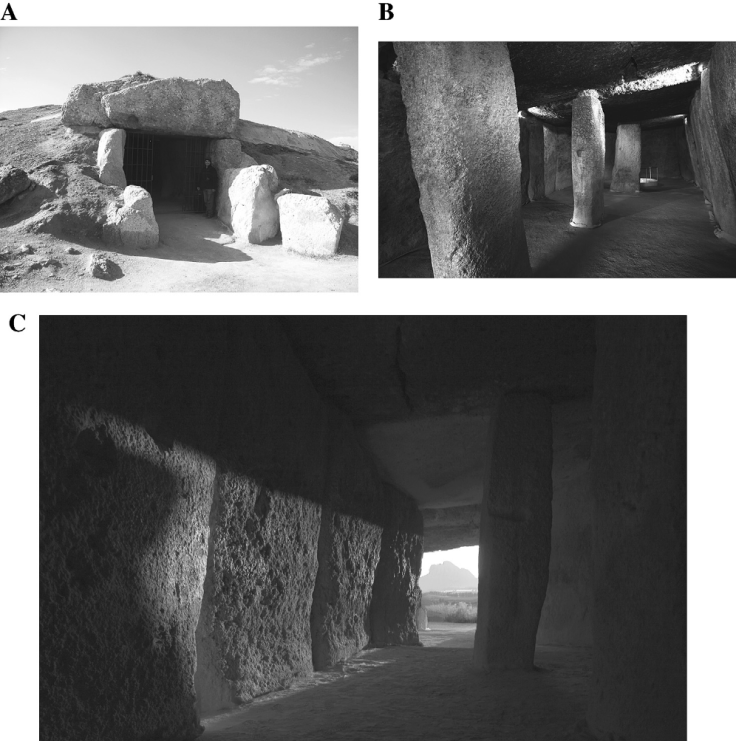
Menga Dolmen. A. Atrium. B. Interior chamber. C. View from the chamber towards the outside in summer solstice
The paintings at Menga, which were evidently poorly preserved, were erased almost completely when the site was last cleaned. From the point of view of the study of rituals, the demonstration of several operations on the stones is extremely important information to be able to interpret the “biography” of the monuments.
The megaliths we see today are the final outcome of a sequence of transformation, maintenance and rebuilding. Interpretations with a testable basis in the protocol for the analysis of the decorations in monuments have yielded data that would have been unimaginable for this kind of assessment only a short time ago. This dynamic hypothesis regarding the large constructions is beginning to determine points of reference in a large part of the structures that have been studied in depth. This is the case of the Antequeran dolmens. Although the graphic documentation has not been fully completed, the evidence so far obtained in Menga and Viera have revealed the major role of the reuse of the oldest stones in their constructions. We also suspect that stones were reused in Romeral, as indicated by the menhir fragments cited in other studies.
Similarly, the system of the preparation of stones in both monuments and the decorative applications relate the two structures very closely, and this leads to a necessary reflection on the possible source of the large steles that were used to create the dolmens of Menga and Viera as we see them today.
It is possible that Menga had a carved door in its outer access that was restructured at some time in its use. Indeed, the position of this stone would coincide with that of a possible threshold.
Engravings are found on some stones in Menga, especially on Pillars 1 and 2. These are narrower and rounder kinds of relief. They usually form geometric motifs in rows, including wavy lines and zigzags. Their sides and the upper parts display irregular cuts in a surface that had been shaped previously, and these produce a very striking toothed profile. Of particular interest is the smoothing of the areas in relief, which created a special quality to the raised surfaces.
In Menga, some evidence suggests that large steles were included in the monument. This may be the case of Orthostat 10, cut through on the top right by some abrupt blows that reveal a semi-circular head through the volumes obtained. However, the clearest work is seen in the headstone that was noticeably cut and smoothed on its left side. The original stele was placed on its side with the top towards Orthostat 11 and three-quarters of it is visible. The other part of it is fragmented or was fitted in the hole where the headstone was placed.
Lime can be seen on the capstones in Menga, as well as some signs of red paint.
Documentation already published about the cover of Menga chamber relates the engraving techniques used with those seen in Viera passage. The current state of the stone does not allow a determination of whether or not it was decorated again; although the white of lime is visible, this is still without analytical confirmation. Photographs taken in the archaeological documentation by the Menga team are able to reconstruct its outer shape with a central protuberance, as well as the careful shaping in its outline, which is clearly trapezoidal.
The other capstones in Menga are noticeably similar in their shape and preparation.
It is quite plausible that the trapezoidal capstones in Menga dolmen, worked around their whole perimeter and displaying clear signs of reproducing anthropomorphic figures, are stones that had seen a previous use.
The trapezoidal shape of these steles means that they were possibly cut into three portions, which seems to be the most common pattern in some uprights in Menga. The pillars may have been made with some of the remaining thirds. A basic study of the thickness of the stones is difficult without more precise measurements of the non-visible sides of each orthostat and capstone. However, the thickness of the stones in the access to Menga is the same as that of the pillars, especially with 1 and 2.
Decoration in the form of black and red stripes over the white layer, which covered the older decoration, of red triangles and relief in red, appears in Menga, where Orthostat 11 and Pillar 1 are clear examples showing that the superimposition of the paintings of triangles by stripes occurred in the large monument.
[Source: “Steles, time and ancestors in the megaliths of Antequera, Málaga (Spain)”, by Primitiva Bueno Ramírez, Rodrigo de Balbín Behrmann and Rosa Barroso Bermejo, 2017]

Last but not least, you may want to watch a video we found in the web showing the interior of the monument:
Research-Selection for NovoScriptorium: Philaretus Homerides
