
Alexander the Great founded the city of Alexandria in 331 B.C. It would later become hugely prosperous, home of the Queen-Pharaoh Cleopatra, famous for its magnificent Museum (Library) and for its 450-foot-tall (140 meters) Lighthouse, one of the wonders of the ancient world.
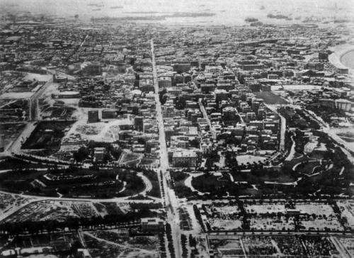
Ancient Alexandria was planned around a main east-west thoroughfare called Canopic Road (See above photo). A study of the ancient route reveals it is not laid out according to topography; for example, it doesn’t run quite parallel to the coastline. But on the birthday of Alexander the Great, the rising sun of the fourth century rose in almost perfect alignment with the road.

Abstract Alexander the Great founded Alexandria in 331 BC. Examining the topography of the city today allows the identification of the essential elements of the original urban system, and shows that the choice of the site was mainly due to religious and symbolic reasons. As a matter of fact Alexandria was the prototype of a series of Hellenistic towns designed as “king’s towns” aiming to make the divine power of their founder explicit. This being the motivation, we examine the orientation of the orthogonal grid, which was based on a main longitudinal axis, and show that this axis is orientated to the rising sun on the day of birth of Alexander the Great. At the time of foundation, “king’s star” Regulus was rising, as well, along the same direction. A series of arguments, based on the topography of the town and on the comparison with later Hellenistic towns and monuments – such as Seleucia on the Tigris and the Nemrud Dag – is given to support the thesis that this orientation was not due to chance but was, instead, a deliberate one.
During the 4th century several debates concentrate on the idea of “ideal town”. Socrates, in the Gorgia, anticipates a new conception of town which goes beyond mere practical principles, and Plato repeatedly prefigures the birth of the ideal city (e.g. Laws IV, V). The inspiring principles are based on harmony as related to the laws and the divine, reflected in the mathematical rigour of the design of the “Hippodamean” city plan (Castagnoli 1971, Shipley 2005). Slightly later, Aristotle will combine such ideas with a sort of “biological” way of thinking linked to the concept of variety and several necessities, stating for instance the need for springs and fortified walls.

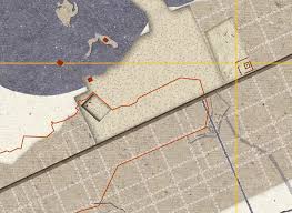
Alexander the Great founded Alexandria in 331 BC (Bagnall 1979). The foundation of Alexandria can be set as the apex of such debates, as well as the beginning of a series of new towns, the ones of the Seleucids (Wheeler 1968). The city becomes an explicit representation of the power of its divine founder, the rigorous order of its plan being a reflection of the “cosmic” order, in compliance with the “orthogonal grid” principles. The orthogonal grid of Alexandria can still be perceived, and forms the basis for an ongoing project of reassessment of antiquities into a coherent architectural scheme of fruition (Ferro and Pallini 2008, Torricelli 2010a, 2010b). The town was wholly designed from the very beginning in all its details, with a relatively huge perimeter, and was divided into five areas named after the first five letters of the Greek alphabet. The original matrix route was conceived on the basis of a longitudinal axis, later called Canopic Road; the most important transverse axis was a dyke (Eptastadion) connecting the mainland with the isle of Pharos. The Canopic Road played the role of an “extended centre”, a wide, longitudinal open space, with the main buildings distributed along it, thus avoiding the idea of a “central point” as the focus of the urban plan. The first to put in evidence such a “longitudinal” character in the original project of Alexandria was 19th century astronomer Mahmud Bey Al-Falaki (1861). Later excavations along the modern street showed that the Canopic Road was actually deeply etched in the rock subsoil (Breccia 1914). The axis is thus a peculiar characteristic, a sort of icon in the foundation of the city, and as such it is an independent architectural unity (Mumford 1967, Caruso 1993, Ferro 2010). It will be repeated in later town projects and, in particular, in the design of Seleucia on the Tigris.
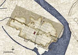
The city was planned in a strip enclosed between the sea to the north and west, the marshy lands of the Canopus mouth of the Nile to the east, and Mareotis Lake to the south, in contrast with many of the healthy criteria of Alexander’s tutor, Aristotle (Bernand 1995). Further, a series of preliminary works was required in order to construct in the desired place: Alexander’s Romance reports about the existence of 12 channels which had to be dried in order to cover them with streets, and excavations have in fact shown the existence of at least 3 of such channels. Another characteristic (to be discussed later on) which clearly conflicts with utilitarian principles is that the orthogonal grid seems to be not conformal to the characteristics of the landscape. All in all, we are led to consider the foundation of Alexandria as a truly symbolic act, inspired by “religious” criteria and aiming at the celebration of Alexander’s power and divine nature (Ross Taylor 1927). Such a foundation probably was in compliance with the – already old – ritual: indeed the founders visited an oracle before starting their enterprise. Typically, it was the oracle at Delphi. Alexander, however, visited the most important oracle in Egypt, the Ammon oracle at Siwa, and this probably occurred just before the foundation (Bradford Welles 1962).

Among the possible symbolic aspects related with foundation and to be considered in the analysis of a town’s project is, of course, orientation. In particular, it has been repeatedly suggested that several Roman towns, whose orientation does not conform to peculiar features of the landscape, were oriented in accordance with astronomical, rather than utilitarian, criteria. This fact has been recently investigated in a systematic way in the case of Roman towns in Italy (Magli 2008). The present paper aims at investigating the same issue in the case of the orientation of Alexandria.

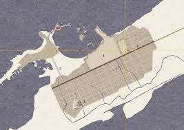
Conclusions Alexandria was deliberately orientated towards the rising sun on the day of birth of Alexander and the rising of the king’s star Regulus. As a final observation, we may notice that the orientation of the Alexandria grid was not dictated by topographical reasons. Indeed, the natural choice would have been to trace the longitudinal axis parallel to the shoreline, which has a mean azimuth around 49° (the ancient shoreline of Alexandria was very similar to the present one, while extended submerged areas exist in the Abukir bay, see Goddio and Bernand 2005). Interestingly, when Roman architects sat about to construct the Caesareum (probably founded by Cleopatra in honour of Mark Antony and later dedicated to Caesar Augustus), they apparently felt the “failed” orthogonality of the grid to the main shoreline direction as a disturbing fact, because planning the temple in conformity to the existing grid did not give a satisfactory view of the monument from the port and therefore to the people arriving from the sea. So they decided to break the symmetry of the grid: the temple is now lost but its position has been reconstructed on the basis of the obelisks which were still standing in Alexandria in the 19th century, and – at least according to McKenzie (2008) – the front formed an angle of (roughly) 15° (i.e. 64-49) with the pre-existing longitudinal axis.
To conclude, the examples of orientation to Regulus and to the sun at the end of July coming from the Nemrud Dag and from Seleucia are clear hints at the existence of a traditional pattern of orientation first established in Alexandria. Alexander the Great confirms himself, once again, as “marking a major devide in the broad history and archaeology ideas” as Sir Mortirmer Wheeler once said.
(Source: “The astronomical orientation of the urban plan of Alexandria”, by Luisa Ferro and Giulio Magli)
Research-Selection for NovoScriptorium: Philaretus Homerides

Leave a comment