
The fortification of Palamari was brought to light in 1995, by the excavators of the site, Maria Theochari and Liana Parlama, and since then it has been systematically excavated during the following years. Τhe excavation was realized gradually, by parting the area in excavating sections. In each section, the excavation of the Fortification Wall was done both on the internal and the external part, simultaneously, in order to reveal the Wall’s height and at the same time to lighten the pressure applied on the wall, by the heavy ground.

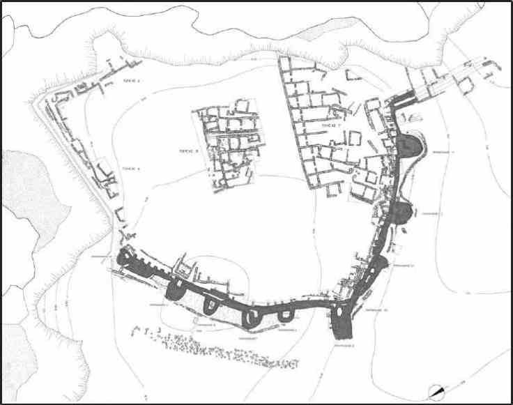
The basic morphological elements of the Northwestern Fortification Wall, which were revealed from the start (the Wall, the Horseshoe-shaped Bastions, the Precinct Wall and the Moat), confirm the importance and the role Palamari played in the Aegean during the 3rd millennium BC and enables its identification to the type of fortification with horseshoe-shaped bastions, as known from Kastri in Syros and other settlements of the Aegean, but also throughout the Mediterranean.
In Aegean, the presence of this fortification type is quite strong. The first sample came up to light during Christos Tsounta’s excavations at Kastri in Syros (late 19th century). In the second half of 20th century, parts of fortifications with horseshoe-shaped bastions have been excavated, or just located, in many settlements, on both Aegean sides (Lerna, Kolona of Aegina, Naxos, Αmorgos, Heraion of Samos, Thasos, Imvros, Liman Tepe). The fortification of all these settlements is certainly related to the protection of metal carrying route from the Black Sea to the Mediterranean, via the Aegean Sea, and also with the circulation of the obsidian.

Palamari is -until today- the most complete sample of this type in the Aegean. The basic form (wall – bastions – precinct walls) is further enhanced with a moat on the west side, which is formed on a natural ground breach. A dam of big pointed stones, which forms an “outwork” (3.00 – 3.50 meters wide) along the western edge of the moat, makes the access to the settlement even more difficult.
The fortification of Palamari was built in the phase Palamari II (late Early Bronze Age
II) and lasted until the abandonment of the settlement in the Middle Bronze Age. It underwent several construction alterations and repairs which, however, didn’t alter its basic form. The two arms of the fortification preserved, enclosed the settlement from its west/northwest and southern side. The north and eastern side of the cape has collapsed throughout the centuries, dragging down a great part of the settlement and the rest of the fortification wall.
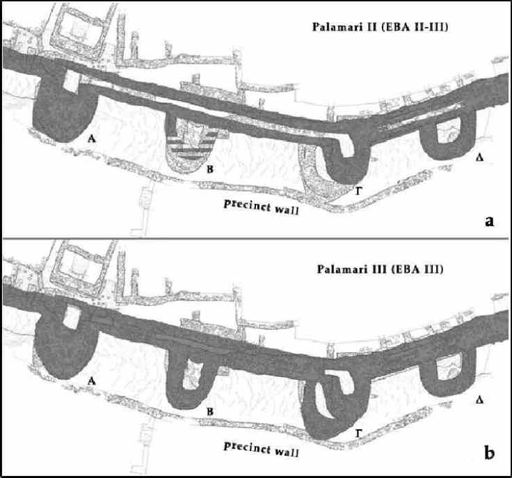
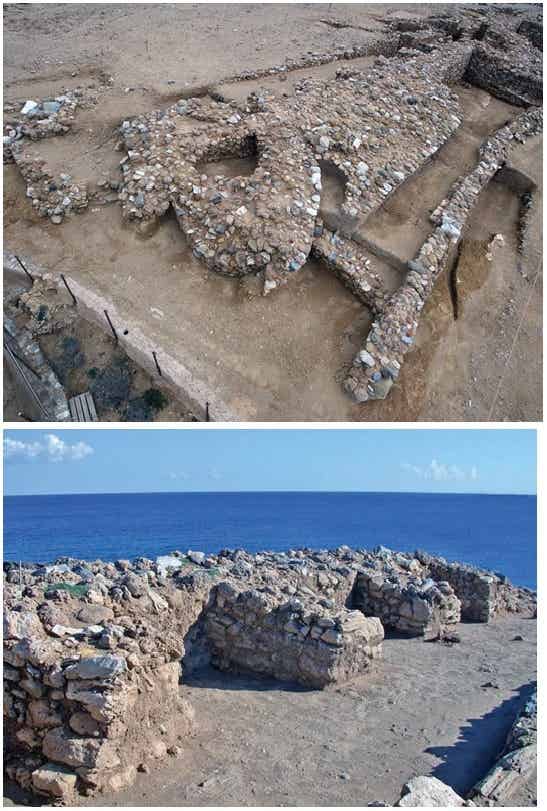
The Northwest part of the fortification has five Bastions and is preserved to a length of approximately 85 meters. It was built directly on the hard rock or, where the rock occurred natural gaps, on a flatten ground. It is preserved in a very good condition, to a height of 2.20 to 3.60 meters and all phases of construction are distinct. The earliest phase of the Wall was built with roughly processed medium sized stones (mostly limestones), tightly built with mud as a connective material. The subsequent phase presents a more careless and hurried work, with bigger and more irregular stones (mostly tufa stones), more loosely built.
The Bastions are built attached to the Wall and they are horseshoe shaped. They differ in size and they are built in irregular distance among them.
Behind the Wall, a series of “abutments” was built in the same phase as was this “platform”, constructed over earlier abutments dated in the earlier phase of the Wall. Similar abutments are found in some parts of the Southern Wall. These constructions do not seem to be there for static purposes, but rather for forming semi-outdoor workplaces, as suggested by signs of fire.
Outside the Northwest Wall, in between the Bastions, consecutive strata were detected, with signs of waste material disposal (chipped obsidian, vessel fragments, animal bones etc.). The microstratigraphic research showed that in many areas there are indications of work-related floors.
The moat (which is a clear indicator for an urban organization and a well-planned construction of the Fortification) was formed by the artificial processing of a natural breach of the rock, which runs along the western side of the cape, from the North to the South, in a length that equals the length of the Northwest Wall. This breach of the rock, as proven by the geological and geophysical researches, had a depth of 6 – 7 meters. Excavations in two different sections revealed a great accumulation of stones, collapsed from the precinct wall, and a great amount of sand, which continues in a great depth, greater than the depth we could excavate with a simple excavation trench, without extra safety measures. The inner edge of the moat is at a short distance from the precinct wall (about 15-60 cm) and its width, wherever this is measured, is more than 5 meters.
Outside the moat, lies the dam of big pointed stones, made of calcareous sandstone. Two hundred and twenty (220) of them are found, most of them in their original place, but many of them fallen sideways. This dam of big stones has a width of about 3.00 – 3.50 meters and a length of 60 meters and used as a first line of defense.
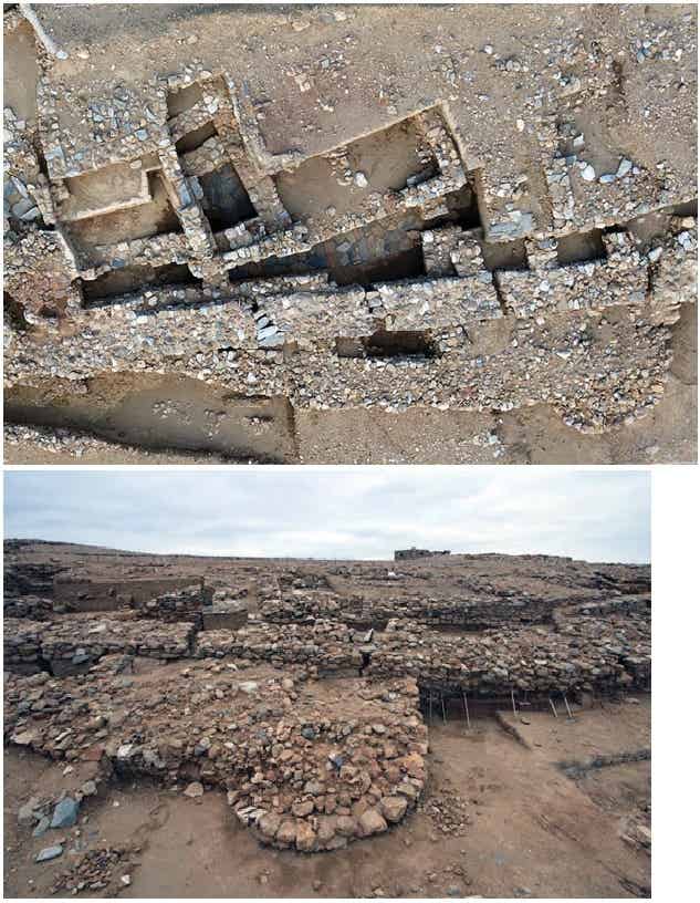
The Southern arm of the fortification is preserved to a length of 85 meters and has three
Bastions. It was founded on a strongly sloping natural terrain, which caused frequent destructions and collapses in many parts of the wall, which is evident by observing the successive repairs and alterations.
The older part of the fortification wall is preserved very well built, but the upper (and later) part presents, in many parts, a strong inclination outwards, while, in some other parts, it has even collapsed. These static problems of the South Fortification led to the construction of multiple “precinct walls”, which possibly functioned as retaining walls.
The natural slope of the hill, we may assume, led to the accumulation of rainwater, and in order to lead the water outside the settlement, successive ducts were opened on the southern fortification wall.
Due to all these static problems, the frequent collapses, the reconstructions and the drainage of the rainwater outside the southern fortification, at this part of the settlement there were no workshop premises or other workplaces outside the wall, in the areas among the bastions (by contrast with those premises located outside the Northwestern Wall), a fact also confirmed by both the archaeological and the microstratigraphic research.
The South Fortification Wall has several construction phases, similar to those of the Northwest Fortification, but there are noteworthy differences when it comes to the construction of the Bastions.
At the southeast part of the settlement, the “plan” of the fortification is quite different: the fortification wall consists of two parallel, strong arms, and changes direction, by turning to the south, at a length of about 40 meters. Between those two arms, a corridor with a width of 1.20 m. is formed, probably some sort of a fortified “street”, which led from the town to the beach and the harbor.
At this southern part of the settlement, a very important finding has come to light, offering more information about the stratigraphy of the area, the settlement before it became a fortified one, and the dating of the construction of the fortification wall: a series of five D-shaped, adjacent buildings, founded on the hard rock, with a size about 5 X 3.5 m. each. They are dated to the Palamari I phase (Early Bronze Age II), before the construction of the fortification. These were possibly public storage rooms, perhaps some kind of granary, with extremely thick and powerful external walls. These D-shaped buildings are a terminus post quem for the construction of the fortification: the fortification wall was erected directly on these buildings during the Palamari II phase (late Early Bronze Age II).

All five phases of the inhabitation of the settlement and of the construction of the fortification are present in the stratigraphy of this area.
In the Middle Bronze Age, Bastions Ζ and H and the two long parallel arms, lost their defensive nature and became a part of the urban system, as evidenced by the remains of habitation onto the fortification.
Summarizing, such a strong and complex fortification, with successive phases of construction that cover a period of a whole millennium (from 2700 to 1700 B.C.), confirms the practice of special activities, such as metallurgy, which were in need of protection, and, of course, the role that Palamari played in the network of fortified, coastal sites of the Aegean.
(Source: “The Fortification of Palamari”, by Christine Romanou)

Summary in English
The prehistoric occupation of Palamari lasts, according to the evidence we have so far, from the EB II period to the end of the MBA. The long period of use and the strong fortification wall, which was built at the end of the EB II period and remained in use until the advanced phases of the MBA, witness to the importance of the site. Parts of MBA houses, containing pottery similar to that found at Poliochni and Troy as well as large quantities of Minyan sherds, had been brought to light since the 1980s in sector B. Excavations between 2000 and 2004 along the entire length of the fortification wall have clarified its sequence, have confirmed its use during the MH period, and have revealed a final phase of occupation during which houses were built over its southern section. In trial trenches in sector Γ part of the MH settlement has been revealed, a complex consisting of megaron-shaped houses built against each other. The complex, has, however, suffered severe erosion.The poster presents information on the finds from different sectors of the excavation. G. Manos was responsible for the excavation in sector Γ, while the fortification wall has been excavated by S. Bonatsos and Ch. Romanou who have also designed and produced the poster.
(Source: “Palamari in Skyros: The Middle Bronze Age Settlement”, by Liana Parlama et al.)

Summary in English
The excavation research at Palamari-Skyros, as well as the study of the findings (although they are still being assessed) revealed important data on the sequence of phases of the EBA and MBA pottery at the Northeastern Aegean. This presentation focuses on the initial results from a cross trench at the south part of the settlement inside the fortification Wall. At the area all the chronological phases (from EBA II to MBA) have been identified, being grouped in four sequencial phases: Palamari I, dated at EBA II period, where the foundations of the oldest until today known buildings, the 5 D-shaped buildings, on top of which later on the South Fortification Wall was founded. Palamari II, with characteristics of Kastri group at the EBA II and EBA III, Palamari III, with characteristics of the advanced EBA III and Palamari IV, at which the findings of MBA have been included. At this period, the fortification Wall ceased to have a defensive role and finally the settlement was abandoned.
(Source: “Palamari Skyros: Stratigraphy at the northern part of the settlement”, by Stamatis Bonatsos – Christine Romanou)

Summary in English
The prehistoric site of Palamari – located on the northeastern coast of Skyros (38˚ 57΄ 52΄΄N Lat., 24˚ 30΄ 35΄΄ E. Long) – is a fortified settlement of the Early and Middle Bronze Age (3rd and 2nd millennium BC) that has been excavated since 1981 (Parlama 2007, 2009; Parlama et al. 2010). During the excavation, pieces of marine and terrestrial materials suitable for radiocarbon dating were unearthed. This paper reports on the absolute dating of the various inhabitation phases of the site and the calculation of the “marine reservoir effect” for this region of the Aegean by dating contemporaneous pairs of samples consisting of marine mollusc shells-charcoals/or animal bones.
This work represents a case study of a larger-scale project whose objective is to establish a marine reservoir correction curve for the entire Aegean Sea region. This curve will have wide application to the dating of archaeological strata throughout the region and will be particularly useful where marine shells are the only datable material for a site. Although the project emphasizes archaeological applications, the results will be of importance also to palaeo-climatic and palaeo-oceanographic studies.
In total 42 samples of terrestrial and marine origin were collected during two in situ sampling campaigns, in December 2000 and October 2005. During the first campaign 6 samples were selected and dated at the radiocarbon unit of the laboratory of Archaeometry of NCSR “Demokritos” (Facorellis 1996; Facorellis et al. 1998), whereas during the second one, 36 samples, were dated at the Keck Carbon Cycle AMS facility, University of California at Irvine. The latter set of 36 samples were analyzed for species identification prior to dating. The sea shells belonged to the following species: Monodonta turbinata (Von BORN, 1778), Patella rustica (L., 1758), Patella caerulea (L., 1758), Glycymeris sp., Arca noae (L.,1758), Stramonita haemastoma (L., 1766), Monodonta articulata (LMCK, 1822), Patella ulyssiponensis (GMELIN, 1791), Hexaplex trunculus (L., 1758) and Operculum Bolma rugosa (L., 1767) (Sabelli et al. 1990, SoHelME 2005, Delamotte and Vardala-Theodorou 2007, SoHelFI 2007).
The charcoals belong to the following species: Quercus type evergreen, Olea europaea, cf.Erica sp. and Angiosperm (Schweingruber 1990). The animals bones where fragments from different skeletal parts of Caprinae and one part from Bovidae and stable isotope analyses (δ15N and δ13C) indicate that their diet was based on C3 terrestrial plants (Papathanasiou 2000).
The conventional radiocarbon ages were converted to calendrical dates based on the international calibration curves IntCal09 for the charcoal samples and Marine09 for the shell samples (Reimer et al. 2009) and using the calibration program CALIB Rev. 6.0.1. (Stuiver and Reimer 1993). In total 13 marine reservoir correction values ∆R were determined. A detailed description of the calculation of the ∆R value can be found in the literature (Stuiveret al. 1986, Stuiver and Braziunas 1993); Facorellis et al. 1998; Facorellis 2011).
The variations may be due to changes in climate (temperature, fresh water input, etc.) over this period and are probably associated with changes in the movement of sea water masses in this region of the Aegean. It is worth noting that Skyros lies in the region where the cold, low-salinity sea water masses coming from the Black Sea through the straits of the Hellespont, meet with the warm, high salinity masses from the southern Aegean Sea (Aksu et al. 1995). A more detailed discussion of this variation will be reported elsewhere. Results indicate that Palamari on Skyros was inhabited for about 1200 years (ca 2900-1700 BC), i.e. from PE I till the ME II period.
In conclusion, the analysis of samples of terrestrial and marine origin from Palamari has provided information about the plant and animal species used by the residents of the settlement. The combined absolute dating with the 14C method has allowed firstly the precise determination of the inhabitation, which was found to be between 2900-1700 BC and secondly the variation of the local ∆R. The variation over this period can now be used for a more accurate and reliable calibration of the conventional radiocarbon dates of marine samples from the same region and time interval.
(Source: “Radiocarbon dating of Palamari on Skyros and estimation of the marine reservoir effect at the northern Sporades region during Bronze Age”, by Yorgos Facorellis et al.)

Summary in English
In 1997 one of the excavators of Palamari, Ms Elisabeth Xadjipouliou was the first to speak of the specialized activities at the end of the third millennium BC among them–mostly of metallurgy.
Today, 15 years later, starting out with this article and continuing with the excavation finds of all excavation periods in Palamari, there is an attempt to continue research in this area, based on the multiple number of finds at our disposal. Analysis of the chemical composition of metal objects took place at N.C.S.R. “Demokritos” by geologist Dr. John Bassiakos and chemist/archaeometallurgist Dr. Myrto Georgakopoulou; results of the analysis are published in this volume.
The finds consist of copper, lead, silver and gold objects, as well as objects that are connected to pyrotechnology and metallurgical activity such as moulds, slags and parts of crucibles. This particular study presents data on the areas–based on up-to-date data–where such activities are traced, along with basic typology of objects and their stratigraphic sequence. A large number of metal finds and related to the metallurgical activity has come up from the excavations of the years 1981-2006. The metallurgy is represented in all phases of the city with several samples. In total we have 149 copper-based objects, 37 lead ones, 1 gold, 1 silver, 8 sherds of clay crucibles, 25 slags, 2 stone moulds-possibly three, and a clay tuyère. Copper-based objects: 57 pins, 35 needles, 26 punches or awls, 3 chisels/flataxes, 3 fish hooks, tweezers, plates and several small objects. Among them a knife, a spearhead (which belongs to the so-called Aegean type) as well as a spindle-whorl/bead stand out.
Lead objects: Approximately 30 rivets were found, for mending pottery, almost all of them in fragments, 3 spindle-whorls (2 out of surface survey, 1 stratified), 2 hair-rings, 1chisel, 1 triangle object, 2 spools, 1 weight. Metallurgical remains: 2 moulds, 25 slags, 8 sherds from crucibles, 1 tuyère.
Attention must be paid to the sole object that is made of gold (two earring hoops), and a silver part of a pin. Especially slags, fragments of crucibles and moulds compose a set of finds revealing knowledge of metallurgy in Palamari. Should we take into account that the existence of slags, crucibles and moulds imply metallurgical activity occurring in the areas where these objects are found, some specific points stand out where such activity could have occurred. More specifically, high concentrations of finds and metallurgy remains are found:
1. On the NW Fortification, in the area of Bastion OΑ (Palamari Ι).
2. On the sections west of Bastion Η (Palamari Ι and ΙΙ).
3. On the area of the Exploratory Trench 6, on the inside and north of the D-shaped building 1 (Palamari Ι and ΙΙΙ).
4. On Sector Β, especially in room Γ8 (Palamari ΙΙ).
5. On the interior of Bastion ∆ (Palamari IΙ).
6. On the NE end of the settlement (Palamari ΙΙΙ).
7. In the area of Exploratory Trench 7, in areas 1 and 3β-3γ (Palamari IIΙ).
8. On the buildings found on Bastion Η (Palamari ΙV).
Conclusions
Noticing the intensity in finds’ occurrence each period we could clearly state that the knowledge of metallurgy is present in Palamari since its first inhabitation period. Samples, of course, of this first phase are scarce, partly because the precious metal was the subject of frequent and repeated recycling and secondly because this phase of the city has been destroyed to such a great extent compared to the remaining periods. One must not overlook the fact that on the outskirts of the settlement where such potentially disagreeable works took place, the strong fortification was erected later on, burying perhaps forever any other traces of metallurgy. Afterwards, however, we notice a smooth, increasing tendency which perhaps might indicate that this technology was no longer property of the people of the settlement or that more raw material or objects entered the island from afar. The two weapons, though, bear evidence that Palamari also followed the technological revolution that occurred in the wider Aegean region, since knifes and spearheads are the first metal weapons created and are closely aligned to the development of metallurgy.
Weapons, fishing and hunting gear, jewelry, stone-carving tools, tools for processing textile and leather, for pottery and carpentry. Metal became the solution for specialized works, facilitated and enabled development became the subject of power and glory.
(Source: “Metal finds from Palamari”, by Stamatis K. Bonatsos)
Research-Selection for NovoScriptorium: Philaretus Homerides

Leave a comment