
In this post we present and analyze two excerpts from Pindar the lyric poet.
Olympian 10: For Hagesidamus of Western Locri Boys’ Boxing
Ancient Greek: “ὁ δ᾽ ἄρ᾽ ἐν Πίσᾳ ἔλσαις ὅλον τε στρατὸν λαίαν τε πᾶσαν Διὸς ἄλκιμος υἱὸς σταθμᾶτο ζάθεον ἄλσος πατρὶ μεγίστῳ: περὶ δὲ πάξαις Ἄλτιν μὲν ὅγ᾽ ἐν καθαρῷ διέκρινε, τὸ δὲ κύκλῳ πέδον ἔθηκε δόρπου λύσιν, τιμάσαις πόρον Ἀλφεοῦ μετὰ δώδεκ᾽ ἀνάκτων θεῶν. καὶ πάγον Κρόνου προσεφθέγξατο: πρόσθε γὰρ νώνυμνος, ἇς Οἰνόμαος ἆρχε, βρέχετο πολλᾷ νιφάδι. ταύτᾳ δ᾽ ἐν πρωτογόνῳ τελετᾷ παρέσταν μὲν ἄρα Μοῖραι σχεδὸν ὅ τ᾽ ἐξελέγχων μόνος ἀλάθειαν ἐτήτυμον χρόνος.”
English: “But the brave son of Zeus gathered the entire army and all the spoils together in Pisa and measured out a sacred precinct for his supreme father. He enclosed the Altis all around and marked it off in the open, and he made the encircling area a resting-place for feasting, honoring the stream of the Alpheus along with the twelve ruling gods. And he called it the Hill of Cronus; it had been nameless before, while Oenomaus was king, and it was covered with wet snow. But in this rite of first birth the Fates stood close by, and the one who alone puts genuine truth to the test, Time.”
Source for the Greek text.
Source for the English text.
NovoScriptorium: “the brave son of Zeus” mentioned here is Hercules. He is the one who named the (World-known in our epoch) Hill of Cronus in Olympia, Elis, Greece. Hercules was believed by the Greeks to have been the founder of the Olympiads.
The phrase “it was covered with wet snow” should be more accurately translated as “it was wetted by a lot of snow“.
The phrase “But in this rite of first birth the Fates stood close by, and the one who alone puts genuine truth to the test, Time” should be better translated as: “in this first ceremony the Fates (Μοῖραι) were represented and Time (χρόνος); the only one who reveals the real truth“
Also of interest is the phrase: “the Hill of Cronus; it had been nameless before, while Oenomaus was king“.
Clearly, any people -and surely the Greeks- since the beginnings of spoken word, had the habit to assign a name to anything around them, especially if it played a role, minor or major, to their everyday life. Here we obviously examine a case where this specific hill remained ‘nameless’ for a long time because it must have had no use for the people’s life. It must have been covered by snow for quite a few years so that such a thing happens. We are convinced that here we deal with a Palaeoclimatic reference. The reference to Oenomaus could be very misleading; he was said to be the grandfather of Atreus, father of Agamemnon and Menelaus who faught in the Trojan War. But he was also said to have lived during the same time interval with Pelops and Danaus! These are two completely different epochs: one refers to the so-called ‘Mycenean’ era (around the beginnings of the 13th c. B.C.), while the other one refers to much earlier times. So, there must have been at least two different men with the same name (this is not surprising; since the Classical era, and even more during the Hellenistic and Graeco-Roman times, ancient stories about several different people with the same name were ‘unified’ as if they had been the deeds of one and only man. Hercules’ example is one of the most known). The name itself is also of interest: Deriving from οἶνος (=wine) and μάω (=desire), it certainly refers to an era when wine production or/and consumption was known in the Peloponnese. While wine-making in Greece is documented since the Neolithic Age, wine-making in the Peloponnese is not yet documented before the 3rd millennium B.C.. Even if there was no wine production in the Peloponnese before that, it cannot be excluded that wine was imported there from elsewhere. Trade in Neolithic Aegean/Greek peninsula is already well documented.
Olympian 3: For Theron of Acragas Chariot Race
Ancient Greek: ” ᾧ τινι, κραίνων ἐφετμὰς Ἡρακλέος προτέρας, ἀτρεκὴς Ἑλλανοδίκας γλεφάρων Αἰτωλὸς ἀνὴρ ὑψόθεν ἀμφὶ κόμαισι βάλῃ γλαυκόχροα κόσμον ἐλαίας: τάν ποτε Ἴστρου ἀπὸ σκιαρᾶν παγᾶν ἔνεικεν Ἀμφιτρυωνιάδας, μνᾶμα τῶν Οὐλυμπίᾳ κάλλιστον ἄθλων δᾶμον Ὑπερβορέων πείσαις Ἀπόλλωνος θεράποντα λόγῳ. πιστὰ φρονέων Διὸς αἴτει πανδόκῳ ἄλσει σκιαρόν τε φύτευμα ξυνὸν ἀνθρώποις στέφανόν τ᾽ ἀρετᾶν. ἤδη γὰρ αὐτῷ, πατρὶ μὲν βωμῶν ἁγισθέντων, διχόμηνις ὅλον χρυσάρματος ἑσπέρας ὀφθαλμὸν ἀντέφλεξε Μήνα, καὶ μεγάλων ἀέθλων ἁγνὰν κρίσιν καὶ πενταετηρίδ᾽ ἁμᾶ θῆκε ζαθέοις ἐπὶ κρημνοῖς Ἀλφεοῦ: ἀλλ᾽ οὐ καλὰ δένδρε᾽ ἔθαλλεν χῶρος ἐν βάσσαις Κρονίου Πέλοπος. τούτων ἔδοξεν γυμνὸς αὐτῷ κᾶπος ὀξείαις ὑπακουέμεν αὐγαῖς ἁλίου. δὴ τότ᾽ ἐς γαῖαν πορεύεν θυμὸς ὥρμα Ἰστρίαν νιν: ἔνθα Λατοῦς ἱπποσόα θυγάτηρ δέξατ᾽ ἐλθόντ᾽ Ἀρκαδίας ἀπὸ δειρᾶν καὶ πολυγνάμπτων μυχῶν, εὖτέ νιν ἀγγελίαις Εὐρυσθέος ἔντυ᾽ ἀνάγκα πατρόθεν χρυσόκερων ἔλαφον θήλειαν ἄξονθ᾽, ἅν ποτε Ταϋγέτα ἀντιθεῖσ᾽ Ὀρθωσίᾳ ἔγραψεν ἱράν. τὰν μεθέπων ἴδε καὶ κείναν χθόνα πνοιᾶς ὄπιθεν Βορέα ψυχροῦ. τόθι δένδρεα θάμβαινε σταθείς. τῶν νιν γλυκὺς ἵμερος ἔσχεν δωδεκάγναμπτον περὶ τέρμα δρόμου ἵππων φυτεῦσαι.”
English: “for anyone over whose brow the strict Aetolian judge of the Greeks tosses up around his hair the gray-green adornment of olive leaves, fulfilling the ancient behests of Heracles; the olive which once the son of Amphitryon brought from the shady springs of the Danube, to be the most beautiful memorial of the Olympian contests, when he had persuaded the Hyperborean people, the servants of Apollo, with speech. With trustworthy intentions he was entreating them for a shady plant, to be shared by all men and to be a garland of excellence in the grove of Zeus which is hospitable to all. For already the altars had been consecrated to his father, and in mid-month the full evening’s eye shone brightly, the Moon on her golden chariot, and he had established the consecrated trial of the great games along with the four years’ festival beside the sacred banks of the Alpheus. But Pelops’ sacred ground was not flourishing with beautiful trees in the valleys below the hill of Cronus. He saw that this garden, bare of trees, was exposed to the piercing rays of the sun. And so his spirit prompted him to travel to the land of the Danube, where the horse-driving daughter of Leto had received him when he came from the mountain-glens and deep, winding valleys of Arcadia; through the commands of Eurystheus, compulsion from his father urged him on the quest of the doe with the golden horns, which once Taygete had inscribed as a sacred dedication to “Artemis who sets things right” [Orthosia]. Pursuing that doe he had also seen that land beyond the cold blasts of Boreas; there he had stood and marvelled at the trees, and sweet desire for them possessed him, to plant them around the boundary-line of the horse-racing ground with its twelve courses.”
NovoScriptorium: This excerpt contains some very interesting information. The myth refers to an era when the Aegeans and the Hyperboreans were strongly related. They clearly had the very same religious beliefs.
“the Hyperborean people” = “the servants of Apollo“
If we take this literally, we may then speak of an era when some King Apollo (obviously a man, not a ‘god’) ruled a ‘Cultural continuum‘ from the Aegean up to the Hyperboreans. But we will discuss this very interesting possibility in a separate future post. For now, we can quickly recall modern scientific proof about the expansion of populations from the Aegean towards the North (e.g. 1, 2). Later on, during the Bronze Age, there is also no doubt about the commercial and (partially) cultural bonds between Europeans (e.g. 3, 4, 5).
“And so his spirit prompted him to travel to the land of the Danube, where the horse-driving daughter of Leto had received him“
The “shady springs of the Danube” are in modern South Germany, while the “land of the Danube” is quite a big region where many modern countries lay. It seems that the lands north of the Danube where called “Hyperborea”.
“Pelops’ sacred ground” = “the mountain-glens and deep, winding valleys of Arcadia” = The Peloponnese
“Arcadia” had been an older name for the “Peloponnese”. Here, Pindar indirectly informs us that the mythological story he records comes from the era when the Peloponnese had the name “Arcadia”.
There are two Palaeoclimatic references in this excerpt; a) the climate in the “shady springs of the Danube” supposedly allowed the existence of the Olive tree back then, and, b) at the time when Hercules brought the Olive tree in the Peloponnese “Pelops’ sacred ground was not flourishing with beautiful trees in the valleys below the hill of Cronus. He saw that this garden, bare of trees, was exposed to the piercing rays of the sun“.
Here we can see the modern ‘Routes of the Olive Tree‘. From here we also learn that: “Olive trees show a marked preference for calcareous soils, flourishing best on limestone slopes and crags, and coastal climate conditions. They grow in any light soil, even on clay if well drained, but in rich soils, they are predisposed to disease and produce poorer oil than in poorer soil. (This was noted by Pliny the Elder.) Olives like hot weather and sunny positions without any shade, while temperatures below −10 °C (14 °F) may injure even a mature tree. They tolerate drought well, due to their sturdy and extensive root systems“.
The above myths will be examined henceforth under the prism of current Palaeoclimatological Research.

A. General Papers
1. From the very informative paper titled “Terrestrial biosphere changes over the last 120 kyr”, by B. A. A. Hoogakker et al. (2016), we read:
“Variations in global climate on multi-millennial timescales have caused substantial changes to terrestrial vegetation distribution, productivity, and carbon storage. Periodic variations in the Earth’s orbital configuration (axial tilt with a 41 kyr period, precession with 19 and 23 kyr periods, and eccentricity with 100 kyr and longer periods) result in small variations in the seasonal and latitudinal distribution of insolation, amplified by feedback mechanisms (Berger, 1978). For the last 0.8 million years, long glacial periods have been punctuated by short interglacials on roughly a 100 kyr cycle. Glacial periods are associated with low atmospheric CO2 concentrations, lowered sea level, and extensive continental ice sheets; interglacial periods are associated with high (similar to pre-industrial) CO2 concentrations, high sea level, and reduced ice sheets (Petit et al., 1999; Peltier et al., 2004; Lüthi et al., 2008).
For European pollen records three biomization methods were used that are region-specific. For southern Europe the biomization scheme of Elenga et al. (2004) was used, where Cyperaceae are included in the biomization as they can occur as an “upland” species characteristic of tundra. For sites from the Alps the biomization scheme of Prentice et al. (1992) was used, and for northern European records the biomization scheme of Tarasov et al. (2000). Fletcher et al. (2010) use one uniform biomization scheme to discuss millennial climate in European vegetation records between 10 and 80 ka BP.
In southern Europe at the four Italian sites (Monticchio, Lago di Vico, Lagaccione, and Valle di Castiglione) the Holocene and last interglacial show highest affinity scores for warm-temperate forest and temperate forest biomes. During most of the glacial and also cold interglacial substages the grassland and dry shrubland biome has highest affinity scores, whereas during warmer interstadial intervals of the last glacial the temperate forest biome had highest affinity scores. At Tenaghi Phillipon and Ioannina a similar biome sequence may be observed, with highest affinity scores for temperate forest and warm-temperate forest biomes during interglacials. During the last glacial and cool substages of the previous interglacial the grassland and dry shrubland biome showed highest affinity scores at Tenaghi Philippon. At Ioannina the LGM and last glacial cool stadial intervals have highest affinity scores for grassland and dry shrubland, whereas affinity scores of glacial interstadial periods are highest for temperate forest. Our biomization results for southern European sites agree well with those of Elenga et al. (2004), who also found a shift to drier grassland and dry shrubland biomes during glacial times. Instead of a desert and tundra biome, Fletcher et al. (2010) define a xyrophytic steppe and eurythermic conifer biome in their biomizations for Europe, giving subtle differences in the biomization records, with the Fletcher et al. (2010) biomized records showing an important contribution of affinity scores to the xerophytic steppe biome. Characteristic species for the xerophytica steppe biome include Artemisia, Chenopodiaceae and Ephedra, which in the southern Europe biomization scheme of Elenga et al. (2000) feature in the desert biome and grassland and dry shrubland biome (only Ephedra).
All four alpine sites are from altitudes between 570 and 670m and for all four sites the last interglacial period was characterized by having highest scores for the temperate forest biome. At Füramoos the last glacial showed highest affinity scores for the tundra biome, whilst during the Holocene the temperate forest biome shows highest affinity scores. In the Fletcher scheme, characteristic pollen for the eurythermic conifer biome includes Pinus and Juniperus. In our biomization Pinus and Juniperus contribute to all biomes except for the desert and tundra biomes.
Most northern European sites are mainly represented for the last interglacial period, apart from Horoszki Duze in Poland. At most sites the temperate forest biome and boreal forest biome show highest affinity scores during the last interglacial (Eemian), whereas cool substages and early glacial (Butovka, Horoszki Duze) show high affinity scores for the grass and dry shrubland biome These results compare well with Prentice et al. (2000), who suggest a southward displacement of the Northern Hemisphere forest biomes and more extensive tundra- and steppe-like vegetation during the LGM.
2. From the paper titled “The temperature of Europe during the Holocene reconstructed from pollen data”, by B.A.S. Davis et al. (2003), we read:
“(Abstract) We present the first area-average time series reconstructions of warmest month, coldest month and mean annual surface air temperatures across Europe during the last 12,000 years. These series are based on quantitative pollen climate reconstructions from over 500 pollen sites assimilated using an innovative four-dimensional gridding procedure. This approach combines three-dimensional spatial gridding with a fourth dimension represented by time, allowing data from irregular time series to be ‘focussed’ onto a regular time step. We provide six regional reconstructed temperature time series as well as summary time series for the whole of Europe. The results suggest major spatial and seasonal differences in Holocene temperature trends within a remarkably balanced regional and annual energy budget. The traditional mid-Holocene thermal maximum is observed only over Northern Europe and principally during the summer. This warming was balanced by a mid-Holocene cooling over Southern Europe, whilst Central Europe occupied an intermediary position. Changes in annual mean temperatures for Europe as a whole suggest an almost linear increase in thermal budget up to 7800 BP, followed by stable conditions for the remainder of the Holocene. This early Holocene warming and later equilibrium has been mainly modulated by increasing winter temperatures in the west, which have continued to rise at a progressively decreasing rate up to the present day.”
“Early Holocene summer MTWA anomalies were lower across Central Europe than Northern Europe, particularly in the CW sector where anomalies were up to 2.0C at the onset of the Holocene. Winter anomalies were also colder in the CE region than NE region, although temperature anomalies in the west were approximately the same following the rapid warming at the end of the Younger Dryas in the NW region. Both summer and winter anomalies in the CW region then follow a similar pattern to the NW region, with a mid-Holocene summer maximum around 6000 BP, while winter temperatures continue to rise, with the overall result that annual temperatures stabilize as summers cool after 6000 BP. The CE region also shows many similarities with the NE region, with delayed summer warming, but also a much less well-defined mid-Holocene maximum. This reflects a much lower overall variation in mid–late-Holocene temperatures in the Central European area, with no real trend in seasonal or annual temperatures in the CE region after 8000 BP.
In comparing our results with other palaeoclimate records from the Central Europe region, it is clear that far fewer records show the large and coherent Holocene warming and cooling trends that characterize Northern Europe. After an initial period of early Holocene warming, our results show temperature fluctuations generally within 1.0°C of modern values.
By 8000 BP, temperatures in all seasons had recovered across Central Europe to values within 1.0C of modern values. In the east, temperatures fluctuated within these limits for the remainder of the Holocene with no clear trends. This agrees with a wealth of evidence from Alpine regions indicating periodic glacier advance and retreat during the Holocene (Hormes et al., 2001). Quantitative estimates based on plant macrofossil and pollen evidence by Haas et al. (1998) also suggest summer temperature varied within 0.7–0.9C above present.
Our results show that the mid-Holocene thermal maximum at 6000 BP is more clearly defined in the west than the east, where the warming occurred earlier and throughout all seasons. In Austria, the Pasterze Glacier was limited in extent during the early Holocene, and was smaller than present for an extended period between 8100 and 6900 BP (Nicolussi and Patzelt, 2000). Further west, evidence for a later and more pronounced mid-Holocene warming is supported by Zoller et al. (1998) and Haas et al. (1998), who found tree lines were highest in Switzerland around 6000 BP. Less well-dated studies have also identified maximum timberline altitudes in the Alps between 9000 and 4700 BP (Tinner et al., 1996) and 8700 and 5000 BP (Wick and Tinner, 1997). In Italy’s Aosta Valley, Burga (1991) identified the period 8300–6000 BP to be the warmest period during the Holocene, with maximum warmth between 6700 and 6000 BP when tree-lines were located 100–200m above present levels. From this timberline change, Burga (1991) estimated summer temperatures were 1.5–3.0C higher than present during this period.
Following the mid-Holocene maximum, summer temperatures declined in the west, although winter temperatures continued to increase.
The pattern of Holocene temperature change reconstructed for Southern Europe generally follows a very different pattern from the regions to the north. Early Holocene summer MTWA and winter MTCO anomalies were actually positive over the SE region, and only slightly negative in the SW in summer. Winter temperature anomalies were 3.0C at the Younger Dryas–Holocene transition over the SW region, but even here they had recovered close to modern levels by 10,000 BP. Temperatures then fell around 1.5 C across the whole region and at all seasons up to 8000 BP, before an almost linear increase up to modern values for all except winter temperatures in the SE. These did not fall below present day values at 8000 BP, and have generally maintained themselves at the same level through to the present day.
Other palaeoclimate reconstructions suggest changes in water balance that could have been brought about by changes in temperature and/or precipitation. Cool temperatures and/or higher precipitation in the early to mid-Holocene have been proposed by Harrison and Digerfeldt (1991) to explain high lake levels throughout the Mediterranean at this time. They also note that Holocene aridity was established more abruptly in the west than the east where lake levels declined more slowly. This latter finding is compatible with our own that temperatures (and hence evaporation) during the important winter recharge period increased along with summer temperatures in the west, but remained relatively stable in the east.
Wetter early to mid-Holocene conditions have also been suggested from isotopic analysis of fossil charcoal in southern France (Vernet et al., 1996), as well as speleothems in Israel (Bar-Matthews et al., 1997). Further evidence for anomalous cool or wet conditions comes from the presence of an early Holocene sapropel in the Mediterranean marine record centred around 8000 BP and spanning between ca 10200 and 6400 BP (Mercone et al., 2000).
This reconstruction does not show a mid-Holocene thermal optimum, as has been suggested by many authors (Houghton et al., 1990). This is in agreement with previous pollen-based studies for this period, which demonstrated that summer warming was confined to Northern Europe whilst Southern Europe cooled (Cheddadi et al., 1997). Here we show however that, not only was high latitude mid-Holocene warming numerically balanced by low latitude cooling, this balance was maintained throughout the Holocene.
There is no evidence of a late-Holocene decline in sea levels that would be expected with widespread neoglaciation following a mid-Holocene thermal maximum (Broecker, 1998).
Significant regional and seasonal variations in temperature patterns have nevertheless occurred within a remarkably balanced total energy budget. This budget has remained stable following the final disappearance of residual LGM ice around 7800 BP. There has been no net annual response to seasonal changes in insolation, and no apparent late Holocene neoglacial cooling at the European scale.
The traditional mid-Holocene thermal maximum is shown to be confined to Northern Europe, and more especially to the summer months. This insolation driven warming was balanced by a mid-Holocene thermal minimum over Southern Europe counter to the expected insolation response. The cooling is also counter to some marine-based interpretations of mid-Holocene climate in the Mediterranean.
From the mid-Holocene onwards, temperatures in Central Europe have only shown small-scale changes without the large-scale warming/cooling trends that characterise the areas to the north and south. This stability probably accounts for the preponderance of studies from this area that argue for a Holocene climate of short-term fluctuations.
Southern Europe and the Mediterranean have undergone an almost linear warming from around 8000 BP. This warming predates the onset of any major human impact and continues at the same rate through the anthropogenically important late-Holocene. This suggests not only a predominantly natural origin for the Mediterranean climate, but also that the pollen-climate calibration method has remained independent of human impact on the vegetation.”
3. From the paper titled “Climate warming and vegetation response after Heinrich event 1 (16 700–16 000 cal yr BP) in Europe south of the Alps”, by S. Samartin, O. Heiri, A. F. Lotter, and W. Tinner (2012), we read:
“(Abstract) Chironomids preserved in a sediment core from Lago di Origlio (416ma.s.l.), a lake in the foreland of the Southern Swiss Alps, allowed quantitative reconstruction of Late Glacial and Early Holocene summer temperatures using a combined Swiss–Norwegian temperature inference model based on chironomid assemblages from 274 lakes. We reconstruct July air temperatures of ca. 10 C between 17 300 and 16 000 cal yr BP, a rather abrupt warming to ca. 12.0 C at ca. 16 500–16 000 cal yr BP, and a strong temperature increase at the transition to the Bølling/Allerød interstadial with average temperatures of about 14 C. During the Younger Dryas and earliest Holocene similar temperatures are reconstructed as for the interstadial. The rather abrupt warming at 16 500–16 000 cal yr BP is consistent with sea-surface temperature as well as speleothem records, which indicate a warming after the end of Heinrich event 1 (sensu stricto) and before the Bølling/Allerød interstadial in southern Europe and the Mediterranean Sea. Pollen records from Origlio and other sites in southern Switzerland and northern Italy indicate an early reforestation of the lowlands 2000–1500 yr prior to the large-scale afforestation of Central Europe at the onset of the Bølling/Allerød period at ca. 14 700–14 600 cal yr BP. Our results suggest that these early afforestation processes in the formerly glaciated areas of northern Italy and southern Switzerland have been promoted by increasing temperatures.”
“The early Late Glacial warming at 16 000 cal yr BP as inferred by chironomids is neither evidenced in the oxygenisotope records from Greenland ice cores (Björck et al., 1998; Svensson et al., 2008) nor in stable oxygen isotope studies of bulk sediments or ostracods in the Northern Alps (e.g. Lotter et al., 1992; von Grafenstein et al., 1999). Variations in these oxygen-isotope records are in good agreement with temperature changes reconstructed by other palaeoclimatic proxies from Europe north of the Alps such as chironomid records (e.g. Heiri and Millet, 2005; Heiri et al., 2007a; Larocque-Tobler, 2010; Lotter et al., 2012). Pollen sequences unambiguously document that north of the Alps afforestation did not start before the onset of the Bølling interstadial at 14 700 cal yr BP (e.g. Lotter, 1999; Litt et al., 2001, 2003). However, a chronologically poorly constrained, though characteristic expansion of Betula nana, evidenced both by pollen and macrofossils, occurred at many sites north of the Alps prior to the Bølling-Allerød interstadial. This dwarf birch phase has been attributed either to pedogenesis or to an increase in summer temperatures (Ammann and Tobolski, 1983; Gaillard, 1985), but has also been interpreted as the result of increasing atmospheric CO2 concentrations that started rising between 17 000 and 16 500 cal yr BP (Lourantou et al., 2010). On the basis of the available dates (some on terrestrial macrofossils) the expansion of the dwarf birch tundra has been dated to 17 500–15 000 cal yr BP (Welten, 1982; Ammann and Lotter, 1989). A substantial warming (to values of 15 C for mean July temperature and 0 C for mean January temperature) has been inferred based on few coleopteran taxa at the beginning of the dwarf birch phase (Gaillard and Lemdahl, 1994). Other insect records from the Swiss Plateau suggest lower mean July temperatures of 10–12 C for the period before the onset of the Bølling-Allerød interstadial (Elias and Wilkinson, 1983). At Schleinsee (southern Germany) Wagner-Cremer and Lotter (2011) inferred an increase in growing degree-days (cumulative temperature >5 C) and hence an extension of the growing season before the onset of the Bølling-Allerød interstadial. This evidence is based on epidermal cell morphology of Betula nana leaves and again chronologically not well constrained. According to the only available radiocarbon date this event may have an age of 15 400–14 700 cal BP and is hence significantly younger than 16 500–16 000 cal BP.”
“A temperature increase in the range of 2–4 C at the onset of the Bølling-Allerød interstadial was also recorded in chironomid records from northern Italy (Heiri et al., 2007b; Larocque and Finsinger, 2008), the Jura Mountains (Heiri and Millet, 2005), and the Northern Alps (Larocque-Tobler, 2010; Lotter et al., 2012). Wagner-Cremer and Lotter (2011) reconstructed for Schleinsee, southern Germany, an increase from 600 to 700 growing degree-days. This shift was simultaneous with the shift in oxygen isotopes in bulk carbonate towards higher values at the onset of Bølling-Allerød interstadial. The Bølling/Allerød interstadial is considered to represent the same event as GI-1 in the NGRIP 18O record, the onset of which has an estimated age of ca. 14 650 cal yr BP (0 = 1950 AD) (Svensson et al., 2008). The age for the beginning of the Bølling/Allerød interstadial of 14 550 cal yr BP in the Origlio record is thus in good agreement with other northern-hemispherical records considering the chronological uncertainty of ca. ±235 yr for this period.”
“Warming between 16 700–16 000 cal yr BP in the Mediterranean realm, coupled with rising atmospheric CO2 concentrations was sufficient to allow forest spread where moisture availability was not limiting tree growth. The crucial role of moisture for forest growth in the Mediterranean is evidenced by the striking postglacial afforestation gradient along the Italian Peninsula, which is inverse to temperature (Tinner et al., 2009). Forests expanded at 16 500–16 000 in northern Italy (Vescovi et al., 2007) and at 14 500–13 000 cal yr BP in central (Magri, 1999; Magri and Sadori, 1999; Drescher-Schneider et al., 2007; Colombaroli et al., 2008) and southern Italy (Allen et al., 2002), whereas afforestation was delayed until ca. 10 000 cal yr BP in the upland areas (Sadori and Narcisi, 2001) and until 7000 cal yr BP in the drier (and warmest) coastal lowlands of Sicily (Tinner et al., 2009). At present evidence for a similar early summer temperature warming north of the Alps as the one detected in northern Italy is sparse. Since the region north of the Alps was deforested and potentially affected by a tree immigration lag, palaeobotanical proxy records cannot resolve this question. Other comparable, well-dated, and quantitative summer temperature records are presently lacking. However, it is likely that a marked summer temperature gradient existed between Southern Europe and the rest of the continent, where unambiguous evidence of a warming in the period 16 000–16 700 cal BP is lacking. The huge ice sheets that were still covering wide parts of Northern Europe at that time will have affected atmospheric circulation in Northern and Central Europe. In addition, the final recovery of the meridional overturning circulation in the North Atlantic did not occur before the onset of the Bølling/Allerød interstadial (McManus et al., 2004). Therefore, ocean circulation recovery after Heinrich event 1 may have been insufficient to trigger substantial climatic warming in Central and Northern Europe prior to 14 600 cal yr BP. This implies that between 16 700 (end of Heinrich event 1) and 14 700 (onset of Bølling/Allerød interstadial), meltwater events and associated variations in ocean circulation contributed to a north–south temperature gradient in Europe, which may have been significantly steeper than after the recovery of the Atlantic meridional overturning circulation when northern hemispherical ice coverage quickly decreased (McManus et al., 2004).”

B. Greece – Peloponnese – Mediterranean
1. From the very informative paper titled “Glaciation in Greece: A New Record of Cold Stage Environments in the Mediterranean”, by Jamie C. Woodward and Philip D. Hughes (2011), we read:
“In his seminal review of glaciation in the Mediterranean region, Messerli (1967) reported evidence for Pleistocene glacial activity in several areas of upland Greece and assigned all the glacial phenomena to the last (Würmian) cold stage.
Evidence for glacial activity has been identified throughout the Pindus Mountains from Mount Grammos (2523 m) on the Albanian border to Mount Taygetos (2407 m) in the southern Peloponnese.
In general terms, during Pleistocene cold stages, the glaciers of Greece decreased in size with decreasing latitude, although climatic and topographic controls could be locally important. Well-preserved glaciated terrains of Pleistocene age have been observed in the highest parts of the northern Peloponnese (Mastronuzzi et al., 1994).
At some of the Greek sites discussed in Messerli’s (1967) review, the evidence for glacial activity is rather limited in areal extent—being confined to the highest peaks— and modern investigations have not yet taken place. In some of these cases, cirques, ice-steepened cliffs and ice-scoured bedrock surfaces account for most of the evidence for the action of former glaciers, with only very limited evidence for the transport and deposition of glacial sediments to lower elevations.
In the 1960s, when Messerli (1967) produced his synthesis, radiometric dates were not available for any of the glacial records in the Mediterranean and this situation remained largely unchanged for over 30 years. The past decade, however, has seen major advances in geochronology with dating frameworks based on a range of methods (including uranium-series, cosmogenic radionuclides, OSL and tephrostratigraphy) emerging for glacial records across the Mediterranean.
Research in Greece, using uranium-series dating, has been at the forefront of these developments.
Recent work has shown that the mountains of Greece contain evidence for multiple phases of ice build-up and decay during the Middle and Late Pleistocene. Detailed field-based mapping has only been carried out in two areas: on Mount Olympus and the surrounding piedmont zone (Smith et al., 1997) and on Mount Tymphi in northwest Greece. The morphological and sedimentological evidence for glaciation is less extensive and less well preserved in central and southern Greece.
The uranium-series ages from Mount Tymphi show that the most extensive glaciations took place during the Middle Pleistocene and not during the most recent cold stage and the global LGM(MIS 2). The alluvial record in the Voidomatis basin shows how the shift from full glacial to interglacial conditions can take place very rapidly.
Large areas of the Mediterranean region are dominated by uplifted carbonate terrains, and the glacial sediments are often cemented by carbonate materials than can be dated by uranium-series methods. The uranium-series ages reported here indicate that glaciation was extensive on Mount Tymphi during MIS 6 and earlier cold stages. We also present the first dated evidence for glacial activity in the Mediterranean region before 350 ka. Together, these ages show that many of the glacial landforms have been very well preserved and that ice build-up on Mount Tymphi (and perhaps in the rest of the Pindus Mountains) was much less extensive during the Late Würmian.
Robust geochronologies are required to compare the timings of glaciations in the different mountain areas of the Mediterranean. At present, the geochronological framework for glacial sequences is patchy, although there has been a dramatic increase in the number of studies in the past decade—mainly utilising cosmogenic nuclide analyses to date glacial surfaces.
There is little doubt that the glacial sediments and landforms in the mountains of southern Europe form an important record of Quaternary environmental change.”
2. From the very informative paper titled “Holocene environmental changes and climate variability in the Eastern Mediterranean. Multiproxy sediment records from the Peloponnese peninsula, SW Greece”, by Christos Katrantsiotis (2019), we read:
“The Peloponnese peninsula in SW Greece at the most south-eastern point of Europe offers the opportunity to explore the presence of such regional climatic differences and/or common patterns. The peninsula is characterized by a west-east rainfall/ temperature gradient attributed to its topography and the influence of different atmospheric circulation patterns from the mid-latitude and the low-latitude regions. Therefore, comparison of climate records from the western and eastern parts of the peninsula can reveal shifts in the large-scale teleconnections that affect the Mediterranean region. In addition, the Peloponnese peninsula offers a broad spectrum of natural archives (e.g. speleothems, lake sediments) allowing climate reconstructions with high temporal and spatial resolution. The peninsula is also rich in archaeological findings with numerous well-preserved and precisely dated archaeological sites and is thus highly interesting for studies on how climate changes have impacted different societies in the past”
“Despite the abundance of paleoclimatic data, proxy interpretations in the Peloponnese are complicated by the interaction of various environmental factors, i.e. tectonics, sea level changes and human activities in the landscape development. These factors might cause similar variations in the proxy records, which can impede the unambiguous separation of climate from non-climatic signals. In this case, a multiproxy approach derived from independent sources will potentially help to discriminate between different environmental factors, and particularly to identify synchronous changes in proxy records attributed to a common climate mechanism. In addition to this, the comparison of records from different sites of the Peloponnese can enable the separation of local environmental changes from regional climate signals.”
“The Peloponnese peninsula constitutes the southern part of the Greek mainland covering an area of 21.549 km². The terrain exhibits variable morphology characterized by rugged mountains, hills, broad plains and valleys. The peninsula is crossed by a large mountain range, which geologically is the extension of the Pindos Mountains stretching from the Greek-Albanian borders (NW) to central Greece. The average altitude in the peninsula is ca 543 m with the maximum elevation being ca 2400 m in the Taygetos mountain chain, in the central-southern Peloponnese. Climatic conditions are spatially and temporally diverse due to the irregular topography and the impacts of different atmospheric circulation patterns. Overall, the Peloponnese has mild, wet winters and hot, dry summers. Most of the precipitation falls between October and April. The NNW-SSE mountain range across the peninsula causes a rain shadow effect on the leeward (eastward) side of the mountain with respect to the westerly winds (Dotsika et al., 2010). As a result, the eastern Peloponnese is dominated by drier and cooler conditions than SW Peloponnese”
“The Peloponnese is located at the junction of different atmospheric circulation patterns (NAO, NCP, and Siberia High). During autumn, winter and early spring, frontal depressions from the Atlantic and the western Mediterranean produce significant precipitation amounts associated with negative NAO and NCP modes (Flocas and Giles, 1991). Saharan depressions contribute to the rainfall totals as they move north–northeast and pick up moisture over the Mediterranean. The eastern Peloponnese receives high rainfall amounts and occasional snowfall associated with cold northerly winds and cyclogenesis over the Aegean Sea during positive NCP periods. During summers, the northward extension of the Hadley circulation causes atmospheric stability. In addition, the area is affected by the Asian monsoon system through modulating the intensity of large-scale subsidence and the strength of the Etesians (Tyrlis et al., 2013). Strong Etesians trigger cooler conditions in NE Peloponnese compared to SW Peloponnese located on the lee side of the mountain. Despite the summer aridity, shortwave troughs and cutoff lows can sporadically cause enhanced instability and thus convective rainfall events”
“The Peloponnese is located in the direct vicinity of the Hellenic arc, i.e. the convergence of the African and the Eurasian plate, and is also characterized by a large number of active neotectonic faults. These factors make the peninsula one of the most tectonically and seismically active areas in Europe. It has been subjected to destructive earthquakes like those of 1875 (Magnitude=6, Kyparissia), 1886 (M=6.8, Filiatra), 1903 (M=6.6, Κythira) and in 1986 (M=6.0, Kalamata) (Papazachos and Papazachou, 2003; Fountoulis and Mavroulis, 2013; Papadopoulos et al., 2014). In addition to high seismicity, the coastal areas of the peninsula have been impacted by tsunamogenic events during the Holocene and beyond associated with large magnitude earthquakes along the Hellenic arc (Vött, 2007; Scheffers et al., 2008; May et al., 2012; Willershäuser et al., 2015).”
“The Peloponnese has a long history of human activity which extends back to the Paleolithic age.”
NovoScriptorium: In terms of Time, this excellent publication examines variations in Climate during the last 6,000 years.
3. From the very informative paper titled “Climate in the eastern Mediterranean during the Holocene and beyond – A Peloponnesian perspective”, by Martin Finné, we read:
“The eastern Mediterranean region has a long history of human presence. The region is one of the cradles of agriculture and it has seen the development and demise of numerous state formations. During the course of human history the climate has always varied and played an important role in the broad interplay between humans and their environment. The long presence of humans has left innumerous traces in the form of archaeological and historical remains. Exploration and excavation of these remains have created a wealth of long and detailed archaeological and historical records from the region. The richness of archaeological data from the eastern Mediterranean region offers an opportunity to investigate how climate variability has affected human societies and activities over long periods of time. However, there is a lack of paleoclimate data from many archaeologically rich areas of the eastern Mediterranean, hampering investigations about climate-society interactions. This knowledge gap is a main motivation behind this thesis. With the onset of the Holocene epoch, around 11 500 years ago, climate conditions rapidly improved from the cooler and more arid conditions that prevailed during the last ice age. At roughly the same time the development of agriculture and a sedentary lifestyle during the Neolithic revolution led to more people coming to inhabit the eastern Mediterranean region and forming more complex societies. The Holocene is therefore highly relevant to study in closer detail, in order to understand the interrelations between climatological and archaeological-historical perspectives (e.g. Caseldine and Turney, 2010; Sinclair et al., 2010; Roberts et al., 2011). To critically investigate such interrelations may offer new ways of interpreting archaeological and historical records. This can yield new and deeper understandings of processes behind cultural change, avoiding oversimplifications when discussing cause and effect behind for example climate changes and societal changes (Caseldine and Turney, 2010; Weiberg and Finné, 2013).
The Holocene climate includes a number of rapid climate changes, so-called climate events, some of the better known occuring around 8200 years BP (the so-called 8.2-event), around 4200 years BP (the 4.2-event), and around 3200 years BP (the 3.2-event) (Alley et al., 1997; Mayewski et al., 2004; Kaniewski et al., 2010). During all three events the climate is suggested to have become rapidly cooler and more arid around much of the globe, including the eastern Mediterranean. Evidence for a climate deterioration during the 8.2-event is quite strong from the Mediterranean region and the negative impacts of this event on the Neolithic, and last Mesolithic societies, have been shown by for example Berger and Guilaine (2009). The 4.2-event is perhaps the best known and most debated climate event of the three (e.g. Mayewski et al., 2004; Wanner et al., 2008). In archaeology, the possible impact of the 4.2-event on societies is much discussed, for instance the decline of the Akkadian state in the Near East around this time has been explained by rapidly increasing aridity (Weiss et al., 1993; Cullen et al., 2000). Recently the 3.2-climate event and its archaeological impacts have been investigated in for instance Syria and Cyprus (Kaniewski et al., 2010; 2013) and southern Greece (Drake, 2012).
The Peloponnese peninsula makes up the southern part of mainland Greece. The peninsula is topographically variable with a core of a high-altitude mountainous area, with narrow and elongated areas of river valleys, grabens and lowland along the coast. The peninsula is rich in archaeological remains reflecting its long history of human activity which extends back to, at least, the Paleolithic age (e.g. Runnels, 1995; Shelmerdine, 1997; Bintliff, 2012).
The temporal analysis shows evidence of generally wetter conditions in the region in the period from 6000 to 5400 years BP. The wetter conditions are most likely associated with the early Holocene, northern hemisphere, insolation maximum. In the following period from 5400 to 4600 years BP, conditions become drier but still remain wetter than average for the period. A wet period around 5000 years BP is clearly manifested in the temporal analysis. After a transitional period from 4800 to 4400, drier conditions come to dominate in the eastern Mediterranean in the period from 4600 to 1400 years BP. For the last part of the period covered (i.e. after 1400 years BP) the number of proxy records are too few to draw any firm conclusions from. From our analysis it is clear that dry conditions prevail in the region around 4200 years BP, the time of the proposed 4.2-event, however, there is little unequivocal evidence of a rapid climate deterioration in the region. Rather, the evidence from the review suggests that it is masked or mediated by the overall climatic change that started around 4600 years BP.
The compilation and analysis of absolute temperature records generally shows little fluctuation in sea surface temperatures (SST) during the past 6000 years.
The record from Glyfada Cave shows that the climate over the Peloponnese rapidly responded to interstadial and stadial conditions over Greenland. During stadial (interstadial) conditions colder (warmer) and drier (wetter) conditions are reflected by depleted (enriched) δ13C values in the speleothems from Glyfada Cave. The depositional hiatuses in Glyfada Cave stalagmites correspond to periods of severe cold conditions in the northern Hemisphere and reduced precipitation over the Peloponnese, most likely forced by a southward displacement of Mediterranean cyclone tracks due to expanding northern ice sheets and increased snow cover over the European continent. The Glyfada Cave record generally supports previously published stalagmite records from the Mediterranean region (Genty et al., 2003; 2010; Fleitmann et al., 2009) and pollen studies from Greece. The comparison between our record and the pollen records from Ioannina (Tzedakis et al., 2002; 2004) and Megali Limni (Margari et al., 2009) revealed a time lag during the first half of MIS 3 which is larger than can be explained by dating uncertainties.
During the last glacial period rapid shifts in the climate have been revealed by the study of polar ice cores. Temperatures in Greenland went through abrupt shifts from colder Greenland stadials (GS) to warmer Greenland interstadials (GIS) following a cyclic pattern, known as Dansgaard-Oeschger (DO) cycles (Dansgaard et al., 1993; NGRIP Members 2004; Svensson et al., 2008). Additionally, at the end of a series of DO cycles GS episodes of extremely cold and dry conditions occurred regularly during the last glacial
period. These episodes, known as Heinrich (H) events, were initially discovered as horizons of ice rafted debris in marine sediment cores from the North Atlantic (Heinrich, 1988; Bond et al., 1993; Broecker, 1994). Subsequent studies have shown the impact of GIS and GS conditions and H events also at lower latitudes. The rapid shifts in temperatures over Greenland during the late Pleistocene with warmer stadials (GS) and colder interstadials (GIS) are repeated over much of the European continent and the Mediterranean Sea and surroundings (e.g. Cacho et al., 1999, 2006; Sánchez Goñi et al., 2000, 2002, 2008; Bar-Matthews et al., 2003; Bar-Matthews, 2014; Bartov et al., 2003; Genty et al., 2003; 2005; 2010; Martrat et al., 2004; Spötl et al., 2006; Drysdale et al., 2007; Ampel et al., 2008; Wohlfarth et al., 2008; Fleitmann et al., 2009; Langgut et al., 2011; Rowe et al., 2012; Torfstein et al., 2013). During GS conditions, especially those associated with Heinrich events, conditions were cold and dry as a result of the shutdown of the North Atlantic meridional overturning circulation, in concert with an expansion of the polar vortex, causing outbreaks of polar or continental air (Allen et al., 1999; Sanchez Goñi et al., 2002; Tzedakis et al., 2002, 2004; Margari et al., 2009; Fletcher et al., 2010; Müller et al., 2011).
During Heinrich events, conditions in the Mediterranean region were very cold and arid (Allen, 1999; Sanchez Goñi et al., 2002; Margari et al., 2009; Müller et al., 2011).
In Glyfada Cave it is inferred that a depositional hiatus occurred corresponding in time with H5, although not confirmed by thin section analysis there are visual indications of a perturbation in growth. Stalagmite growth also seems to have ceased around the time of H4 but the uncertainties in the age-depth model makes it impossible to know if the growth period between 39 ± 3.4 and 37 ± 3.6 ka preceded or succeeded the hiatus. The Glyfada δ13C record shows how the biological activity above the cave controlled by precipitation and temperatures over the Peloponnese rapidly responded to changing temperatures over Greenland. During GS conditions, more enriched δ13C values signal a reduction in vegetation and microbial activity in the soil zone and the opposite during GIS conditions. This interpretation is supported by local pollen data from Ioannina in NW Greece, Tenaghi Philippon in NE Greece and Megali Limni in E Greece which all show contractions in tree populations and increases in plants adapted to cooler and drier conditions during GS.
In the early and Mid-Holocene the climate in the eastern Mediterranean was generally wetter and cooler than in the late Holocene (e.g. Robinson et al., 2006; Roberts et al., 2008; Paper I). During the early Holocene insolation was stronger in the Northern Hemisphere (Berger and Loutre, 1991) which caused a northward shift of the climate system and more convective precipitation to fall over the Sahara which was then a savanna (Kuper and Kröpelin 2006; Kröpelin et al., 2008).
During the last glacial period (Marine Isotope Stages 5a–3) the climate over the Peloponnese rapidly responded to Greenland interstadials and stadials. During warmer (colder) interstadial (stadial) conditions vegetation and soil microbial activity responded rapidly reflected by depleted (enriched) δ13C of the speleothems from Glyfada Cave. Depositional hiatuses occurring in Glyfada during MIS 4 and the latter part of MIS 3 reflect dry conditions corresponding to a southward shift of Mediterranean cyclone tracks brought about by large and/or expanding ice volumes in the Northern Hemisphere.
During the last 6000 years three main climate periods have been identified in the eastern Mediterranean: 1) From 6000 to 5400 years BP conditions were mainly wetter than average, 2) in the period 5400 to 4600 years BP conditions remained mainly wetter but less so than the previous period, and 3) 4600 to 1400 years BP drier conditions came to dominate the regional picture. However, there are periods of increased moisture.”
4. From the paper titled “Evidence for a warm and humid Mid-Holocene episode in the Aegean and northern Levantine Seas (Greece, NE Mediterranean)”, by M. V. Triantaphyllou et al. we read:
“(Abstract) Marine and terrestrial biological and biogeochemical proxies in three sediment cores from North and SE Aegean and northern Levantine Seas record continuous warm and humid conditions between 5.5 and 4.0 ka BP related to the establishment of relatively stratified conditions in the upper water column. These conditions may have resulted from the concordant albeit weak Mid-Holocene South Asian monsoon forcing, combined with lighter Etesian winds. During this interval, sea surface temperatures fluctuate in the Aegean Sea, although exhibiting a strong positive shift at~4.8 ka BP. The warm and humid climatic conditions triggered upper water column stratification and enhancement of the deep chlorophyll maximum (DCM), leading to dysoxic conditions and the deposition of a sapropel-like layer, but only in the SE Aegean site. In contrast to the shallow water SE Aegean, the deeper North Aegean and the northern Levantine sites, although experiencing stratification in the upper parts of the water column, did not achieve bottom-water dysoxia. Thus, a top–bottom mechanism of stratification–DCM development accompanied by fast transport and burial of organic matter is a likely explanation for the preservation of productivity signal in the shallow sites of the SE Aegean and establishment of sapropelic conditions during the warm and humid Mid-Holocene. The termination of the Mid-Holocene warm and humid phase coincides with the ‘‘4.2 ka’’ climate event. Our data exhibit an N–S time transgressive aridification gradient around the Aegean Sea, most probably associated with the reorganization of the general atmospheric circulation during the Mid-Holocene.”
5. From the paper titled “The climate of the Mediterranean basin during the Holocene from terrestrial and marine pollen records: A model/data comparison”, by Odile Peyron et al. (2016), we read:
“During the early Holocene, relatively wet conditions occurred in the south-central and eastern Mediterranean region, while drier conditions prevailed from 45°N northwards. These patterns reversed during the late Holocene, with a wetter northern Mediterranean region and drier conditions in the east and south.
Reconstructions for the Aegean Sea indicate higher summer and annual precipitation. Winter conditions reverse the early to mid-Holocene trend, with wetter conditions in the northern Aegean Sea and drier conditions in the southern Aegean Sea.”
6. From the paper titled “Late postglacial paleoenvironmental change in the northeastern Mediterranean region: Combined palynological and molecular biomarker evidence”, by K. Kouli et al. (2011), we read:
“(Abstract) Three gravity cores collected from the NE Mediterranean (NEMR) across a transect from the northern Aegean Sea (North Skyros basin) to the south Cretan margin (SCM), were investigated for pollen and terrestrial biomarkers derived from epicuticular waxes of vascular plants during the last ∼20 ky. Pollen data show diversified mixed temperate forest in the northern borderlands and enhanced Mediterranean vegetation in the southern areas, documenting an N-S climatic trend. Terrestrial plant biomarkers and their diagnostic geochemical indices exhibit latitudinal patterns which are interpreted in terms of the different delivery pathways (fluvial/runoff vs. atmospheric transport), resulting from the climate conditions during different periods. During the Late Glacial and early deglaciation periods (20-14 ka BP) relatively increased humidity (H-index) is recorded in the north Aegean Sea, while in the South drier climate was the limiting factor for vegetation development.”
7. From the paper titled “Short-term climate changes in the southern Aegean Sea over the last 48,000 years”, by Maria Geraga et al. (2005), we read:
“(Abstract) High-resolution palaeoenvironmental changes, corresponding to a mean time interval of 450 years covering the last 48,000 years, were examined in a core from the Cretan Basin in the southern Aegean Sea. The intensity and duration of the climatic and oceanographic events were determined by examining the compositional changes in the planktonic foraminifera and pollen assemblages, along with the y18O signal of Globigerinoides ruber. A reconstruction of sea-surface temperatures was attempted using the Modern Analogue Technique (MAT). In total, 10 stadials and 6 interstadials occurred over the last 48,000 years. These fluctuations in climatic conditions coincide with fluctuations documented in the western and central Mediterranean and seem to be associated with Dansgaard–Oeschger events. Some of these climatic fluctuations are correlated with changes in the vegetation in the surrounding land. Between 48 and 10 cal kyr BP the most pronounced stadials occurred at 41 cal kyr BP (C69-ST10) and at 13 cal kyr BP (C69-ST4). These events are characterized by: (i) high positive y18O values of Globigerinoides ruber, (ii) drops in SST and (iii) increases in aridity. These events may be correlated with the Heinrich H4 event and the Younger Dryas event, respectively. Two other stadials at 23 cal kyr BP (C69-ST6) and at 16 cal kyr BP (C69-ST5) which are characterized by increases in the abundance of the cold plaktonic foraminifera species and increases in aridity may be correlated with the H2 and H1 events, respectively. The dominant planktonic foraminiferal species during the stadials which are correlated with the Heinrich events were Turborotalita quinqueloba and Globorotalia scitula. The most pronounced interstadials occurred between 39.5 and 38.5 cal kyr BP (C69-IST6) and between 25 and 24 cal kyr BP (C69-IST3) and are characterized by depletion in y18O values, increases in SST and increases in humidity. The former event coincides with the formation of the sapropelitic layer S2. In the Holocene the most pronounced stadial occurred between 8 and 6.5 cal kyr BP (C69-ST2), during the interruption of S1 and is characterized by a reduction in SST and an increase in aridity. The most pronounced interstadials of Holocene occurred during the formation of S1a and S1b between 9 and 8 cal kyr BP (C69-IST1) and between 6.5 and 5.5 cal kyr BP (C69-IST2), respectively. These events are characterized by depletion in y18O values, increased SST and an increase in humidity as is indicated by the expansion of temperate evergreen and Mediterranean taxa in the pollen record.”
8. From the paper titled “Last glacial geomorphologic records in Mt Chelmos, North Peloponnesus, Greece”, by Kosmas Pavlopoulos et al. (2018) we read:
“(Abstract) This study deals with the analysis of the glacial processes that have affected the relief of Mt Chelmos in northern Peloponnesus, Greece during middle and Late Pleistocene. The goal was to compile a combined geomorphological-geological map of the study area which would enable the chronological stratification of the glacial landforms cropping up on Mt. Chelmos. Chronological stratification was further aided by optically stimulated luminescence (OSL) dating. The map served as the basis upon which the reconstruction and discussion on the phases of the Middle-Late Quaternary paleoclimatic history of Mt. Chelmos have been made. A sophisticated semi-automated method was first used to analyze the Digital Elevation Model (DEM), combined with Aster, Quickbird and ALOS imagery in order to identify glacial and periglacial, as well as karstic features. Then, these features along with other non-recognizable features from the remote-sensing images were documented in the field. In this way, several glacial landforms were identified, such as moraines and cirques, indicating extended glaciation phases during the middle and Late Pleistocene. Additionally, a ground moraine located at an altitude of 1900-2050 m, within the Spanolakos glacial valley, was dated using the OSL-dating method. The resulting ages indicate a phase of glacier advance/stabilization during MIS-5b (89-86 ka), which is in consistence with pollen-record evidence from Greece and the Mediterranean.”
“In the mountains of Peloponnesus (e.g. Taygetos, Chelmos, Erymanthos) several researchers have identified glacial landforms (Philippson 1892; Maull 1921; Mistardis 1937a,b,c, 1946; Mastronuzzi et al. 1994; Pope et al. 2017). The first studies on Mt Chelmos report cirques, moraines, perched boulders and ice-moulded bedrock which are generally attributed to Quaternary glaciers (Philippson 1892; Maull 1921; Mistardis 1937a,b,c, 1946), while Mastronuzzi et al. (1994) date them to Late Pleistocene age. However, the geochronology and the palaeoclimatic context of this glacial evidence have been only partly explored so far. In particular, the only systematic study that has been conducted on Mt Chelmos is by Pope et al. (2017). Their results (based on cosmogenic-36Cl dating of glacial boulders) showed that quite extensive moraine complexes are the result of glacier advance/stabilization during two phases in Late Pleistocene, at 40-30 ka and 13-10 ka respectively, and a glacial retreat phase during 23-21 ka.
The first glacial advance stage suggests that the local Late Pleistocene Last Glacial Maximum (LGM) predates the global LGM during 23-21 ka and is in accordance with evidence from other mountains across the Mediterranean (Pope et al. 2017), namely northern Spain (Serrano et al. 2012a, b), the Italian Apennines (Federici et al. 2012) and Turkey (Sarikaya et al. 2014) opening up a new perspective on the study of the Tymphian Stage. Practically, as the latitude difference of the two mountains (Mt Chelmos and north Pindus/Mt Tymphi) is relatively small, any differences in the extent of glaciations should mainly be attributed to precipitation differences rather than temperature differences, implying a relatively wet climate in southern Greece during these periods.”
“The stage of glacier retreat (23-21 ka) in Mt Chelmos, around the global LGM (22-20 ka), is consistent with evidence of dry conditions around the LGM from northern Greece (Pope et al. 2017), as mentioned above. Finally, the last glacial advance phase (13-10 ka) probably corresponds to the Younger Dryas (12.9-11.7 ka), being consistent with evidence from Montenegro (Hughes et al. 2010, 2011) and the Italian Maritime Alps (Federici et al. 2012).”
“Further evidence, supporting the established glaciation history of Greece during MIS 6, MIS 3, MIS 5b and MIS 2 comes from the work of Hughes et al. (2006e). In this work the authors made an effort to identify the intervals with the most favorable conditions for glacier formation – in terms of temperatures and precipitation – during the late Vlasian Stage (MIS 6) and the Tymphian Stage (MIS 5d – 2) in Northern Greece. The most useful insight came from the study of the high resolution pollen record from the nearby lacustrine sediment core of Ioannina – I284 sequence (Tzedakis et al. 2002, 2004). It is noted that according to Hughes et al. (2006e), major variations in arboreal pollen frequencies in the Ioannina – I284 sequence over millennial time scales, closely match variations in Mediterranean sea surface temperatures (Cacho et al. 1991) as well as isotope records of marine sediments in North Atlantic (Shackleton et al. 2000) and the Greenland ice sheet (Grootes and Stuiver 1997). The drawn conclusions of the above mentioned study, can thus be used in a broader perspective, and are good indicators of glacial activity also for the more southern Mt Chelmos.
The identification of those intervals was based on the fact that precipitation strongly controls the mass balance of glaciers (Ohmura et al. 1992) while o moisture supply and temperatures strongly affect vegetation populations. In this context, major stadials are characterized by low total arboreal pollen frequencies related with arid and cold climatic conditions. However, reduced precipitation during these stadials would have inhibited glacier build-up and would have forced the retreat of pre-existing glaciers (Hughes et al. 2003). Such intervals have been recognized close to the Heinrich Event 2 (24 ka – Hemming 2004) and the LGM (22-20 ka) between 23 and 24 ka and towards the end of the Vlasian stage (MIS 6 / 190-130 ka) at ca. 133 ka (age limit of pollen record).”
“Cold and arid conditions during the LGM would most likely have caused glacial retreat on Mt Chelmos. Another type of favorable intervals for glacier formation is characterized by large differences between total arboreal pollen frequencies and arboreal frequencies excluding the tolerant of cold-conditions Pinus and Juniperus species, reflecting to moist yet cold conditions (Hughes et al. 2006e). Such intervals are recognized between 31 and 35 ka BP, 37 and 39 ka BP and finally 83 and 88 ka BP. These periods seem to be strongly related to the Mt Chelmos glacier phases IIb (MIS 3 / 40-30 ka) and IIa (MIS 5b / 89-86 ka) respectively.”
9. From the paper titled “Glacial history of Mt Chelmos, Peloponnesus, Greece”, by R.J. Pope, P.D. Hughes, E. Skourtsos (2015), we read:
“(Abstract) Mt Chelmos in the Peloponnesus was glaciated by a plateau ice field during the most extensive Pleistocene glaciation. Valley glaciers radiated out from an ice field over the central plateau of the massif. The largest glaciations are likely to be Middle Pleistocene in age. Smaller valley and cirque glaciers formed later and boulders on the moraines of these glacial phases have been dated using ³⁶Cl terrestrial cosmogenic nuclide exposure dating. These ages indicate a Late Pleistocene age with glacier advance/stabilization at 40-30 ka, glacier retreat at 23-21 ka and advance/stabilization at 13-10 ka. This indicates that the glacial maximum of the last cold stage occurred during Marine Isotope Stage 3, several thousand years before the global Last Glacial Maximum (Marine Isotope Stage 2). The last phase of moraine-building occurred at the end of the Pleistocene, possibly during the Younger Dryas.”
10. From the paper titled “Middle to late Holocene palaeoenvironmental study of Gialova Lagoon, SW Peloponnese, Greece“, by Alexandros Emmanouilidis et al. (2018) we read:
“Between 4700 and 5300 cal yrs BP, the increase of Rb/Sr ratio indicates wet climatic conditions”
“During the late Holocene period (3300-2500 yrs BP) a big decline at the Rb/Sr ratio was recorded indicating dry conditions. This can be correlated with the 3500e2500 yrs BP Period of Rapid Climate Change (RCC) that has been recorded for the Mediterranean region by Mayewski et al. (2004) and Staubwasser and Weiss 2006 and the end of the Mycenaean state development.”
11. From the very informative paper titled “Late Glacial to mid-Holocene palaeoclimate development of Southern Greece inferred from the sediment sequence of Lake Stymphalia (NE-Peloponnese)“, by Christian Heymann et al. (2013), we read:
“Dry climatic conditions as indicated by the elemental proxies prevail until 14.7 ka cal BP and most likely represent the Oldest Dryas. Winter precipitation within the catchment is low, while summers are also dry. Between 14.8 and 14.7 ka cal BP summers become wet. There is no evidence of glaciers after 15 ka BP in the mountainous regions of the Peloponnese (Hughes et al., 2006), including Mt. Kyllini, thus changes in catchment hydrology reflect changes in precipitation and not in meltwater input.”
“A shift to humid conditions occurs around 14.7 to 14.6 ka cal BP. Winter precipitation increases, while summers are dry. After 14.6 ka cal BP, precipitation in summer also increases.”
“After 13.9 ka cal BP, climatic conditions as indicated by the elemental proxies of the Lake Stymphalia sequence become drier. From 13.9 to 13.4 ka cal BP, winter and summer precipitation is low. At 13.4 ka cal BP humid conditions in winter with dry summers reoccur and last until 13.2 ka cal BP.”
“At 13.2 ka cal BP a shift to a drier climate with low winter precipitation but humid summers marks the onset of the Younger Dryas at Lake Stymphalia. This period lasts until 12.1 ka cal BP at Lake Stymphalia.”
“The Late Glacial to Early Holocene transition is marked by a shift in Rb/Sr to a wet climate around 12.1 ka cal BP at Lake Stymphalia. These conditions prevailed until 10.8 ka cal BP. Increasing carbonate precipitation suggests drier summers until 11.1 ka cal BP. This trend is reversed until 10.9 ka cal BP.”
“A climatic shift to drier conditions around 10.8 ka cal BP is indicated by Rb/Sr and these dry conditions prevail until 8.5 ka cal BP, although short-term humid winter conditions are centred around 9.8 and 8.7 ka cal BP. Between 10.5 and 8.7 ka cal BP, summers are also dry. This is also indicated by the carbonate content which is highest around 10.2 ka cal BP. A shift to more humid summers occurs around 8.7 ka cal BP and these summer conditions prevail until 8.5 ka cal BP.”
“After 8.5 ka cal BP, Rb/Sr indicates a shift to a more humid climate with peak conditions around 7.5 ka cal BP, although dry reversals are normal.”
“A short-lived shift to drier conditions can be seen in the Rb/Sr record at Lake Stymphalia centred at 8.3 ka cal BP. Both winter and summer conditions are dry.”
“The elemental proxies indicate wet winter and summer conditions from 8 to 7.5 ka cal BP.“
“Increases in magnetic susceptibility indicate humid conditions in the catchment. Summer conditions change after 7.5 ka cal BP to increasing dryness that lasts until 7 ka cal BP. A general shift to a dry climate is also indicated by Rb/Sr with peak dry conditions around 7 ka cal BP. Then after 7 ka cal BP, summers become wetter. Around 6.1 ka cal BP climatic conditions in winter become drier, but Rb/Sr indicates a general shift to a wetter climate around 5.8 ka cal BP.”
“Climate conditions in the Eastern Mediterranean region became more similar to the present day after 7 ka cal BP“
“The record from Lake Stymphalia shows that significant variations in palaeoclimate occurred during the Late Glacial to mid-Holocene.”

C. Central Europe – Southern Germany – Lower Danube
1. From the paper titled “Holocene climate change and prehistoric settlement in the lower Danube Valley”, by C. Bonsall et al.(2012) we read:
“(Abstract) An analysis of the summed probability distributions of 293 radiocarbon dates from Late Glacial to mid-Holocene sites in the Danubian Iron Gates highlights the existence of well-marked 14C discontinuities at c. 9.5–9.0 ka, 8.65–8.0 ka and after 7.8 ka cal BP. These coincide with climate anomalies recorded in Greenland ice cores and palaeoclimate archives from the Danube catchment.”
“We used CalPal and IntCal04 to investigate temporal trends in the radiocarbon date series from the 230 km long Iron Gates reach of the Danube valley covering the time-range from the Late Glacial to the middle Holocene, c. 15,000–5000 cal BP. The resultant summed probability distribution curves show marked discontinuities (periods with reduced frequencies of 14C dates) at c. 9.5–9.0 ka, 8.75–8.0 ka and after 7.8 ka cal BP during the Mesolithic and Early Neolithic. These coincide with well-defined anomalies recorded in palaeoclimate archives from the North Atlantic region and the Danube catchment.”
2. From the paper titled “The Origin and Development of the Central European Man-made Landscape, Habitat and Species Diversity as Affected by Climate and its Changes – a Review”, by Peter Poschlod (2015), we read:
“Climate and the origin of sedentism in central Europe. The first climate optimum after the last ice age started around 6000 BC and lasted until 3250 BC. Causes were an increased solar activity at the beginning and an increased solar radiation during this period (Steinhilber et al. 2009; Nussbaumer et al. 2011). Warmer temperatures permitted a much higher treeline than today. In the central Austrian Alps the treeline laid at 2,400 m a. s. l. compared to 2,250 m a. s. l. in 1980 (Nicolussi et al. 2005). Subfossil remains from thermophilic aquatic plants, such as Trapa natans (von Post 1946; Hultén, Fries 1986; Lang 1994) as well as Najas marina agg. and N. flexilis (Godwin 1975; Lang 1994), but also from animals such as the European pond turtle (Emys orbicularis; Degerbøl, Krog 1951; Sommer et al. 2007; 2009), reveal that they reached their most northern distribution since then.
At the end of the Neolithic age precipitations increased again (often called pluvial period; Schönwiese 1995) which caused an increase in ground water level evident through the increase of paludification and spread of alder carr, for example, in northwest-Germany (Overbeck 1975). For Lake Constance, a strong water level rise has been dendrochronologically dated to 3370 BC (Magny et al. 2006). High precipitation also caused a retreat in pine (Pinus sylvestris) and an increase in common hazelnut (Corylus avellana) in that region. In the south German Federsee, the highest water level was reported at the end of the Neolithic Age. An earlier rise of water level in the Federsee occurred between 4800 and 4500 BC (Wall 1961), in the Lake of Constance between 4600 to 4700 BC (Magny et al. 2006). During both periods, pollen of Cyperaceae, most of their species belonging to wetland plants in central Europe, increased at the Lake Constance (Magny et al. 2006). Water level rises between 6000 and 4000 BC have also been reported from southern Sweden (Harrison, Digerfeldt 1993). Therefore, the first half of the Neolithic period may be also called the wetland expansion period. At the same time, the favourable climate supported the start of sedentism – resulting in the origin of the first man-made habitats, arable fields and pastures (grasslands, heathlands).
Until recently, most studies on central Europe claimed that there was already a closed forest cover everywhere below the timberline (Firbas 1949; 1952; Lang 1994; maps of the natural landscape: Schwickerath 1954; Hueck, Behrmann 1962), except in certain specific habitats such as: gravel islands in river beds (Osborne 1972; 1997; Ellenberg 1996; Gao et al. 2000); rock formations (Meusel 1935; 1939; Gradmann 1950; Müller 1980); “beaver meadows” (Wells et al. 2000; Schneider 1996; Harthun 1998; 1999); open stages during autogenous cyclic succession in alder carrs (Pokorný et al. 2000; Sádlo 2000); and mires (particularly percolation mires; Succow, Jeschke 1986). In contrast to this hypothesis, Vera (2000) claimed that the forests were partly open. His hypothesis is based on the assumptions that the first megaherbivores, which today are partly extinct, such as the aurochs or the European bison, contributed to more open forests (but see Stuart et al. 2004 and Mitchell 2005). However, besides the megaherbivore hypothesis, there are many other aspects and new results which support the hypothesis of a more open landscape, and more open forests, when the first farmers settled (see also Kreuz 2008):
The forests consisted of oak (Quercus spp.), elm (Ulmus spp.), common hazel (Corylus avellana), lime tree (Tilia spp.) and ash (Fraxinus excelsior; Clark et al. 1989). All these species are not so shade-tolerant. Oak, for example, is not able to regenerate by seed under a closed canopy and common hazel would not even flower (Vera 2000). However, the shade-tolerant and most dominant species in the actual potential natural vegetation would be beech (Fagus sylvatica) and fir (Abies alba). Although beech might have already occurred locally in northern Germany before the Neolithic Age (Robin et al. 2016) it has only spread after the first farmers have settled. It may have even immigrated with the first farmers – being an important crop and fodder plant (Bonn, Poschlod 1998) since beech came from the southeast (Slovenia; Magri et al. 2006; Magri 2008) and started to establish only around 5000 BC in southeast Germany (Huntley, Birks 1983; Lang 1994). Fir having come from the south (Konnert, Bergmann 1995; Hewitt 1999) arrived around 4500 BC in southwest Germany (Black Forest; Lang 1994). According to Küster (1997), beech is a synanthropic species, an idea that has recently been confirmed for Bohemia, through its asynchronous immigration (Pokorný 2005), and the northern part of central Europe (Tinner, Lotter 2006), but declined for Switzerland and southern Germany (Tinner, Lotter 2006).
Phylogeographic studies on grassland plants, despite having their main distribution in a Mediterranean climate, such as Eryngium campestre, have shown that they may have survived in central Europe in (micro)refugia (Bylebyl et al. 2008; see also Poschlod 2015).
The first crops were einkorn, emmer, barley, pea, lentil, flax and poppy, crops which evolved in a Mediterranean climate. In central Europe they were grown as summer crops, meaning that they were sown in spring and harvested during summer (Willerding 2003a). This allowed the arable fields to be grazed after harvesting until the next spring. Thus the fields were fertilized and could be managed over longer periods (Kreuz, Schäfer 2011). Arable fields were often managed on a long-term basis without alternating grassland use (Knörzer 1986), since the first settlements of LBK people were established in regions with fertile loess deposits (Jankuhn 1969). This hypothesis of naturally fertile soils is supported through the records of nutrient-demanding or nitrogen-indicating species in the cereal remains of the earliest LBK settlements, such as: Bromus secalinus, Chenopodium album, Galium aparine, G. spurium, Lapsana communis, Phleum pratense, Fallopia convolvulus, Setaria spp., Solanum nigrum (Bogaard 2002; 2004; Kreuz, Schäfer 2011). Nevertheless, depending on the region and soils, either agroforestry, or alternate arable field-grassland and arable field-forest use, or shifting cultivation, have also occurred (Rösch 1990; 1991; Schier 2009). The vegetation of this plant community was composed of indigenous species, but also archaeophytes that came from regions with a Mediterranean climate either from the Near East, Asia Minor or southeast Europe. At least 27 archaeophytes arrived during the Neolithic Age via uncleaned crop seeds, although some might also have been used as fodder plants (Poschlod 2015). Still today, arable weed communities contain the highest proportion of archaeophytes (Willerding 1986). Archeophytes are a reflection of warm climatic conditions through their temperature indicator value which is above average compared to that of the whole central European flora.”
“At the end of the Neolithic period, around 3400 BC, the climate optimum ended and temperatures cooled down. The following cold period, called Piora Oscillation (around 3400 BC to 3000 BC; Zoller 1960), caused a decline of the tree line (Frenzel 1966; Wick, Tinner 1997; Nicolussi et al. 2005) and an expansion of the glaciers in the Alps (Joerin et al. 2006), as well as a decrease in the dominant tree species Tilia and Ulmus (Lang 1994). Temperatures in central Europe were around 1 to 2°C lower (Amesbury et al. 2008; Bleicher, Sirocko 2010).”
3. From the paper titled “Tree rings as a proxy for seasonal precipitation variability and Early Neolithic settlement dynamics in Bavaria, Germany”, by Joachim Pechtl, Alexander Land (2019) we read:
“(Abstract) Studying the dynamic of Neolithic settlement on a local scale and its connection to climate variability is often difficult due to missing on-site climate reconstructions from natural archives. Here we bring together archaeological settlement data and a regional climate reconstruction from precipitation-sensitive trees. Both archives hold information about regional settlement dynamics and hydroclimate variability spanning the time of the first farming communities, the so called Linearbandkeramik (LBK) in Bavaria, Germany. Precipitation-sensitive tree-ring series from subfossil oak are used to develop a spring-summer precipitation reconstruction (5700–4800 B.C.E.) representative for southern Germany. Early Neolithic settlement data from Bavaria, mainly for the duration of the LBK settlement activities, are critically evaluated and compared to this unique regional hydroclimate reconstruction as well as to reconstructions of Greenland temperature, summer sea surface temperature, delta 18O and global solar irradiance to investigate the potential impact of climate on Neolithic settlers and their settlement dynamic during the LBK. Our hydroclimate reconstruction demonstrates an extraordinarily high frequency of severe dry and wet spring-summer seasons during the entire LBK, with particularly high year-to-year variability from 5400 to 5101 B.C.E. and with lower fluctuations until 4801 B.C.E. A significant influence of regional climate on the dynamic of the LBK is possible (e.g. around 4960 B.C.E.), but should be interpreted very carefully due to asynchronous trends in settlement dynamics. Thus, we conclude that even when a climate proxy such as tree rings that has excellent spatio-temporal resolution is available, it remains difficult to establish potential connections between the settlement dynamic of the LBK and climate variability.”
“Temporally, the sequence from later Mesolithic to Early and Middle Neolithic coincides with the Atlantic period which is also referred to as the Holocene Climatic Optimum (7000–3800 B.C.E.). Generally speaking and based on proxy-data with centennial or decadal resolution, during this phase the palaeoclimatic conditions were reasonably stable, somewhat warmer and more humid than in modern times”
“General trend in Bavaria. In northern Bavaria, occupation starts very early, becomes quite intensive at the end of phase I, and remains continuously high thereafter. A smaller decline is only present at the beginning of local Middle Neolithic traditions. In southern Bavaria the onset of the first farming colonisation is delayed and staggered in different regions, the central Lech valley and the Isar estuary being latest. While in the large settlement areas in southeast Bavaria occupation seems continuous but uneasy, the smaller settlement zones in southwest Bavaria even show clear breaks. The fact that a dense and continuous settlement is correlated with areas in which warm and dry climatic conditions prevail is also clearly confirmed in the Bavaria-wide analysis. In the colder and wetter regions, on the other hand, colonisation of the LBK is comparatively unstable or completely absent. In contrast, it is hard to identify synchronous trends in supra-regional development.
A phase of discontinuity seems present during the first half of the older LBK around 5260 B.C.E. From this time on, settlement increases and at least from 5200 B.C.E. on, an overall boom during the older and middle LBK is observed. The beginning of the younger LBK around 5060 B.C.E. is associated with disruptions in some regions (south-central Franconia) as well as with increases of settlement in other regions (central Lech and central Isar). The only general drop occurs at the end of the younger LBK around 4960 B.C.E., followed by a major hiatus. From about 4820 B.C.E. onwards, a wide-ranging resettlement by Middle Neolithic communities is seen.”
“Most striking is the observation that the consistency of settlement patterns over time is clearly dependent on the climatic characteristics of a region. Upper and especially Lower Franconia show much stronger continuity than all regions in southern Bavaria. While southern Bavaria on the whole is characterised by wetter and colder climatic conditions, some of the relatively advantitious regions like the Ries and the southeast settlement areas adjacent to the Danube and the Isar still show reasonably constant occupation. In contrast, particularly at the uppermost Danube and at the Lech, settlement fluctuates strongly. Hence, the stability of settlement is indubitably connected with the climatic conditions of a region.
Archaeological data indicates permanent instability of the settlement system in southern Bavaria—an area that belongs to the least favourable settlement regions with respect to climatic conditions in the entire LBK, and the late date of colonisation might even be due to this”

D. Olive Tree
1. From the paper titled “Neolithic woodland in the North Mediterranean basin: A review on Olea Europaea L”, by Yolanda Carrión et al. (2013) we read:
“At present, Olea europaea L. var. sylvestris is an important element of the vegetation in the circummediterranean area. The species is considered an accurate thermal bioindicator for the definition of the thermo-mediterranean bioclimatic level while its cultivated variety is an emblematic and genuine plant of the Mediterranean cultures from protohistoric times. In the archaeological record the presence of Olea remains, is recorded since prehistoric times in context associated to the Epipalaeolithic, the Neolithic and the Bronze Age periods while great part of the discussion concerning this plant has been dedicated to its domestication and cultivation (Besnard et al. 2002; Breton et al. 2006; Contento et al. 2002; Liphschitz et al. 1991; Rodríguez-Ariza and Montes 2005; Zohary and Hopf 2000).”
“The oleaster occupies the warmest areas of the Mediterranean, approximately coinciding with the thermo-mediterranean bioclimatic level or with the lower meso-mediterranean (Ozenda 1975; Rivas-Martínez 1987). In the western Mediterranean, it extends over low, warm lands with a mean annual temperature of between 17-19ºC. A limiting factor for its development is the mean temperature of the coldest month that should not be below 6ºC (Rubio et al. 2002, 343, figure 1).”
“Since late Prehistory, the olive has been grown for its oil-rich fruit. The cultivated variety, Olea europaea L. var. europaea, has become more flexible to climatic and environmental conditions and therefore extends beyond the previously described area. It penetrates towards higher, colder and more continental lands, mainly on calcareous soils, terra rossa, and sandy marls.”
“In Greece and the Aegean area Olea is infrequent during the earlier part of the Holocene. One reason for the meager identification of the species is probably the fact that the majority of the available charcoal analysis results come from northern sites (Ntinou 2002) that lay outside the area of the natural oleaster distribution, which is confined to the south of parallel 39º N (Ozenda 1975). The available data, mostly from pollen sequences, indicate the late appearance of Olea (towards the end of the Atlantic period) even in southerly thermo-mediterranean locations where the species could potentially grow (Bottema and Sarpaki 2003; Turner and Greig 1975; Jahns 1993; Moody et al. 1996; Wright 1972). At the site of Knossos in Crete wood charcoal analysis (Badal and Ntinou in press) failed to detect the presence of the olive in any of the layers of the Neolithic sequence, despite the fact that typically thermo-mediterranean formations have been identified. In the central Aegean area, the only evidence for the presence of Olea derives from the Cave of the Cyclops, Youra, Northern Sporades, where few charcoal fragments have been identified in the upper part of the sequence, after ca. 8,500 cal. BP, coinciding with the Neolithic period (Ntinou 2011) .”
“In the Liguro-Provençal region, Olea is present at several sites, in levels corresponding to the Atlantic period, and later. These sites are strictly located in the thermo-mediterranean level. At Giribaldi (Thiébault 2001) and Arene Candide (Nisbet 1997), Olea reaches percentages of between 10% and 30%, and is accompanied by other thermophilous species, such as the lentisc and the Aleppo pine. However, Olea is completely absent from other sites located on the meso-mediterranean level, even within a few kilometers distance from the aforementioned sites (Thiébault 2001). Only in Caucade, do Olea and other warm-loving taxa appear in this level, but later in the Atlantic (Thiébault 2001). The data indicate the existence in the Liguro-Provençal region of an area with warm influences constrained to the lowest parts of the thermo-mediterranean level.”
“The presence of Olea since the beginning of the Holocene (11700 cal. BP) has been reported in several sites in the Near East and Cyprus. In contrast, the presence of the olive in the Aegean area and Greece is not well defined. Olea charcoal, pollen and seed macroremains data indicate a late appearance of the olive, after the 9th millennium cal. BP, for Crete, Southern and Central Greece, and much later dates for northern Greece. In the central Mediterranean, the early presence of Olea is confirmed by wood charcoal from Mesolithic levels at Grotta dell’ Uzzo (Costantini 1989). However, the species is systematically absent from the Italian peninsula, even later in the Holocene. In the Iberian Peninsula, the presence of Olea in some southern sequences (Badal 1998; Carrión 2005) is documented continuously since the end of the Pleistocene and during the early Holocene (Carrión et al. 2008).”
“The Atlantic period marks the expansion of Olea, a pattern that is better observed in the western Mediterranean. This may be linked to the aforementioned presence of the species in early post-glacial contexts in this region. On the contrary, Olea is scarce in Italy while in mainland Greece and Crete the majority of sites with Olea remains date to the late Neolithic or the Bronze Age. Whether the species was introduced, as proposed for Crete (Bottema and Sarpaki 2003), or whether it expanded in the wild at a very slow rate and only became abundant with tree-tending and cultivation after the Neolithic, it remains an open question until more results are provided.”
“The distribution of Olea finds indicates that temperature and continental conditions would have been the limiting factors for its expansion. During the Preboreal and Boreal, there are no records for the presence of Olea in the meso-mediterranean level (except for Buraca Grande), thus the later presence of the species there should be linked to its large expansion during the Atlantic period and to the favorable orography of particular areas. In any case, the frequency of Olea and other thermophilous species at this level is sporadic, probably reflecting the prevailing bioclimatic conditions that would have been close to the minima for their growth. The rapid expansion of Olea could have been favored by the higher temperatures during the Atlantic period. However, the human factor may have played a fundamental role in the expansion process, as well. The establishment of Neolithic groups and the farming economy are linked to evidences of deforestation and expansion of sclerophyllous woodland in many palaeobotanical sequences, probably because of woodland clearing practices or the slash-and-burn agriculture. The charcoal analysis record of the Iberian Peninsula shows that Olea was an intensively exploited species in most thermo-mediterranean and in some meso-mediterranean contexts which has led several authors to consider it as evidence of an early manipulation of the species (Terral 1997; Badal 1999).”
2. From the paper titled “The origin and spread of olive cultivation in the Mediterranean Basin: The fossil pollen evidence”, by Dafna Langgut et al. (2019), we read:
“(Abstract) Olive (Olea europaea L.) was one of the most important fruit trees in the ancient Mediterranean region and a founder species of horticulture in the Mediterranean Basin. Different views have been expressed regarding the geographical origins and timing of olive cultivation. Since genetic studies and macro-botanical remains point in different directions, we turn to another proxy – the palynological evidence. This study uses pollen records to shed new light on the history of olive cultivation and large-scale olive management. We employ a fossil pollen dataset composed of high-resolution pollen records obtained across the Mediterranean Basin covering most of the Holocene. Human activity is indicated when Olea pollen percentages rise fairly suddenly, are not accompanied by an increase of other Mediterranean sclerophyllous trees, and when the rise occurs in combination with consistent archaeological and archaeobotanical evidence. Based on these criteria, our results show that the southern Levant served as the locus of primary olive cultivation as early as ~6500 years BP (yBP), and that a later, early/mid 6th millennium BP cultivation process occurred in the Aegean (Crete) – whether as an independent large-scale management event or as a result of knowledge and/or seedling transfer from the southern Levant. Thus, the early management of olive trees corresponds to the establishment of the Mediterranean village economy and the completion of the ‘secondary products revolution’, rather than urbanization or state formation. From these two areas of origin, the southern Levant and the Aegean olive cultivation spread across the Mediterranean, with the beginning of olive horticulture in the northern Levant dated to ~4800 yBP. In Anatolia, large-scale olive horticulture was palynologically recorded by ~3200 yBP, in mainland Italy at ~3400 yBP, and in the Iberian Peninsula at mid/late 3rd millennium BP.”
“Palynological results for the Central Mediterranean This set of records includes nine profiles: two from Greece (Lake Voulkaria and Lake Gramousti), another two from Sicily (Lago Preola and Gorgo Basso), and five from mainland Italy (Albano, Nemi, Accesa (center), Accesa (edge), and Lago Padule). Within the two sequences recovered from Greece, the first half of the Holocene is characterized by an inconsistent appearance of Olea pollen; relatively high values appear at the beginning of the Holocene, around 10,000–9000 yBP (achieving a maximum of 2.9% at Lake Voulkaria and 0.8% at Lake Gramousti). Somewhat higher values are also documented between 7000 and 6000 yBP at Lake Voulkaria (reaching 2.6%). During the second half of the Holocene, olive pollen percentages are more constant at Lake Voulkaria, with increasing percentages observed between ~2600 and 600 yBP (reaching 7.8%). In the Lake Gramousti record, two peaks in olive pollen were registered during the later stage of the Holocene: at ~5100 yBP (1.7%) and at ~1600 yBP (1.4%).”
“The organic residue is therefore only able to point to some familiarity with olive oil, if not to the process of manufacturing itself, in contrast to olive waste which can serve as direct evidence for olive oil production. In the case of macro-botanical remains (wood-charcoal and stones), the situation is more complicated, as described above, especially when trying to distinguish between specimens from the wild and domesticated subspecies. Due to the limitations of these macro-botanical remains for tracing olive cultivation in the early phases of olive domestication, when olive stone sizes had most likely not yet been significantly altered (e.g. Dighton et al., 2017), it seems that the quantitative approach may be considered a relatively reliable indicator for olive cultivation. Still, as in the case of pollen, increasing ratios of olive macrobotanical remains could reflect more favorable climate conditions rather than cultivation. Therefore, this type of evidence should be evaluated not only in relation to its archaeological context (mainly its association with certain implements suggesting specific olive oil processing), but also in relation to the reconstructed environmental conditions.”
“The presence of olive pollen during the early Holocene (~10,000–7000 yBP-albeit frequently) in relatively low proportions, in almost all of the studied palynological records (22 out of 23), clearly demonstrates that the investigated regions were part of the natural distribution area of Olea europaea pollen rain during the Pleistocene and served as areas of refugia during the Last Glacial Maximum period. This includes the following regions: the southern Levant, Anatolia, Greece, Sicily, Italy (peninsula and islands), and the Iberian Peninsula. The records were recovered from Mediterranean coastal areas or from hinterland locations that would most likely be characterized by climates favorable to the wild subspecies. It is possible that other areas, also located in thermo-Mediterranean contexts, would have served as refugia (e.g. the northern Levant, Cyprus, Mediterranean France, and the western coasts of North Africa), though, unfortunately, sufficient and comparable palynological records that meet the criteria of this study are not available from all potential regions. In any case, corroborative evidence is provided by the genetic data, which also point to almost the same locations as refugia areas of oleaster (Besnard et al., 2017). The occurrence of Olea pollen across the Mediterranean already during the Pleniglacial indicates that these areas served as long-term refugia; the increase in olive pollen levels during the beginning of the Holocene, in comparison to late Pleistocene values, is related to the climate conditions characterized by the general increase of temperatures and precipitation during the post-glacial period (Carrion et al., 2010 and references therein). At some point during the Holocene, the rise in Olea pollen can be attributed in most cases to the human factor, specifically the early manipulation of oleaster and its cultivation. These activities played a crucial role in the expansion of Olea across the Mediterranean.”
“Olive cultivation history in the Central Mediterranean Greece. The two records available from Greece indicate that the beginning of the Holocene (~10,000–9000 yBP) is characterized by a scattered olive pollen presence, while during the subsequent two millennia, it is almost absent. Higher values are documented in the Lake Voulkaria (located at sea level) record between ~7000 and 6000 yBP and after ~5200 yBP. At exactly the same time, a peak in olive pollen percentages is documented at Lake Gramousti (400 m a.s.l.). During the second half of the Holocene, the spread of Olea can be observed from the Geometric to the Classical periods (beginning in the early 3rd millennium BP). These high olive pollen frequencies point to olive horticulture, mainly along the coastal lands. Higher olive percentages during these historical periods were also identified in other records from southern Greece (e.g. Vravron area – Kouli, 2012).
In pollen records from southern mainland Greece and from locations in the Aegean and Ionian Seas that were not included in this study, due to relatively low resolution and/or the limited time span they cover, the increase in Olea percentages, indicating the beginning of olive cultivation, is more profound and is dated earlier. The earliest clear evidence of substantial olive pollen rise occurs at ~6000 yBP in the pollen diagrams from Crete (Bottema and Sarpaki, 2003; Moody et al., 1996). A more accurate date is available from the new, high-resolution pollen study by Canellas-Bolta et al. (2018), who suggest an age of ~5600 yBP for the beginning of olive tree management in Crete, when Olea pollen rises from ~17% at ~5700 yBP to ~30% at 5500 yBP. A virtually coeval olive pollen increase has been identified on Zakynthos Island in the Ionian Sea (Avramidis et al., 2013). In the northeast Peloponnese, a significant increase in Olea pollen was registered at a much later date: in the region of Lake Lerna at ~4200 yBP (Argive Plain; Jahns, 1993) and in the region of Kleonai and the Kotihi lagoon at ~3800 yBP (Atherden et al., 1993; Lazarova et al., 2012, respectively). In Macedonia, in the vicinity of Lake Dojran, Olea horticulture is suggested to have begun only at ~2500 yBP (Masi et al., 2018).
The differences between the palynological records regarding the date of the beginning of olive horticulture may reflect the possibility that the initial management of olive tree crops varied from one area to another, with a clear diffusion from south to north.
The late pollen evidence for olive culture in the two records discussed in this study (Lake Voulkaria and Lake Gramousti) is probably the result of their relatively northern location. However, it can be summarized, based on the other available regional pollen sequences presented above, that the earliest profound increase in olive pollen, indicative of olive cultivation in Greece, took place during the ~6000–5600 yBP interval (Figure 7; Crete – Bottema and Sarpaki, 2003; Canellas-Bolta et al., 2018; Moody et al., 1996; and Zakynthos Island – Avramidis et al., 2013). In these pollen diagrams, the sudden dramatic rise in olive pollen curves was not accompanied by increasing pollen percentages of other evergreen Mediterranean sclerophyllous trees. This may suggest that Olea pollen intensification was not climate related. Furthermore, not only did the ratios of other trees of the Mediterranean forest/maquis with similar environmental requirements not increase, but oak percentages (mostly those of the evergreen type) were reduced (Avramidis et al., 2013: Figure 4; Bottema and Sarpaki, 2003: Figure 4; Moody et al., 1996: Figure 8), pointing to the possible replacement of parts of the Mediterranean forest/maquis by olive orchards through human agency, as has been suggested, for example, for the Sea of Galilee region in the southern Levant (Baruch, 1986; Horowitz, 1979: 193).”
“The range of ages pointing to the beginning of large-scale olive management in Crete (~6000 yBP vs ~5600 yBP) could stem from differences in dating methods, but it may also indicate an earlier starting date for olive cultivation in Western Crete. The record reported by Moody et al. (1996) is located in western Crete while the palynological sequence of Canellas-Bolta et al. (2018) is situated at the eastern end of the island. The archaeobotanical data from southern Greece matches the palynological evidence: olive remains become common in the initial stage of the Bronze Age (from ~5300 yBP) and increase during the course of the Bronze Age (Asouti, 2003; Margaritis, 2013; Valamoti et al., 2018 and references therein). Islands have always been regarded as sensitive indicators for environmental change and human pressure, due to their isolation and relatively low resilience.”
“In correlation with the early Holocene pollen spectra, olive stones and wood-charcoal remains also point toward a rare presence of olive trees during the Late and Final Neolithic (9th–7th millennia BP) in some islands in the Aegean and Ionian seas, either growing naturally in small numbers (Valamoti et al., 2018), and/or exploited at a low level (Margaritis, 2013). The archaeological sites from northern and central mainland Greece are characterized by the almost total absence of olive macro-botanical remains during the Neolithic (see review by Valamoti et al., 2018), as well as pollen (e.g. Kouli and Dermitzakis, 2008)*. The number of sites where olive remains have been recovered rises dramatically in both Crete and the Peloponnese from the Bronze Age onwards. Based on the robust archaeobotanical evidence (Margaritis, 2013; Valamoti et al., 2018), and as suggested by Renfrew (1972), the Aegean stands out as the core area from which olive horticulture gradually spread at the onset of the Bronze Age, diffusing from islands and coastal locations to the central mainland and to more northerly regions.
*NovoScriptorium: This is now (2020) proved not to be the case. Please read here.
The earliest evidence from residue analysis for the use of olive oil in Greece comes from two local jar fragments found in the small fortified hilltop site of Aphrodite’s Kephali in eastern Crete, dated to ~5200–4700 yBP (Koh and Betancourt, 2010: Table 1). Martlew (1999) reports that olive oil residues are present at the Late Neolithic site of Gerani Cave in western Crete (dated to ~5800 yBP); however, the results of this study are not conclusive and could point to other vegetal sources (see also critique by Sarpaki, 2012: 41–42).
The relatively late onset of intensive olive cultivation in the Aegean (at least several centuries after the southern Levant) allows for the possibility that it was initiated as a result of knowledge transfer – or even seedling transfer – from the Levant. However, there is no firm archaeological evidence that can point to contiguous links between the two regions. While it is broadly recognized that maritime capabilities grew markedly in the 6th millennium BP, commerce appears to have been limited to the Aegean basin and the west Anatolian coast, on one hand, and to the Levantine littoral (including occasional contacts with Cyprus), on the other hand (Bar-Yosef Mayer et al., 2015; Broodbank, 2013 and references therein), with no archaeological or archaeobotanical evidence for stepping-stones that may have filled the gap. It is therefore possible that the knowledge of olive cultivation spread through maritime connections, but no less likely that olive cultivation in Greece was an independent event*. The latter possibility is supported by genetic studies (Diez et al., 2015), which appear to point to two separate domestication events, one in the eastern and the second in the Central Mediterranean.”
*NovoScriptorium: After the recent (2020) findings from the Theopetra cave this possibility seems to increase.

NovoScriptorium: After having examined a good number of relative publications, it is time to check whether there is a core of truth in these ancient myths (as it should be, according to what the ancient Greeks believed about their Mythological Tradition). Let’s also recall here the words of Pindar: “Time; the only one who reveals the real truth“. It seems as if he indirectly informs us that there is Truth in here but we need the help of Time in order to clarify it out of the poetic mixture.
Conclusion 1: According to the available data, there is no record (so far) of Olea in Southern Germany, the “shady springs of the Danube” of the myth. On the other hand, the olive tree could and can indeed be found at the “land of the Danube” (as North as modern Slovenia). Certainly, though, ‘Hercules’ did not bring the olive tree to Greece from the North or anywhere else. The reference could simply be a suitable exaggerration to serve the purpose of denoting that, at the time when “Hercules” passed from there, there had been some kind of ‘Climatic optimum’ for the region. As we saw above, such a “Climatic optimum” indeed had existed during the Neolithic Age.
Conclusion 2: Because of high tectonical/seismic activity, and because of many tsunamogenic events in the past (also during the Holocene), the collection of ‘stable and continuous (in relation to Humans)’ archaeological data from the Peloponnese (at least until the Bronze Age) is very difficult. In other words, this explains why findings from e.g. the Neolithic Age are sparse and rare in comparison e.g. to those of the Bronze Age. It is no coincidence (on the contrary, it is very reasonable) that research for findings before the Bronze Age in the Peloponnese seems focused mainly on caves. And indeed there have been very important findings in those caves (e.g. 1, 2, 3, 4, 5). It has to be said that this also confirms the ancient Greek claims about ‘various cataclysmic events’ that have taken place in the past. And since this is true, beyond any scientific doubt, it is also apparent that the people who recorded all those very ancient events (of the Palaeolithic, Mesolithic, Neolithic, etc) as a ‘national heritage’ were the very same people throughout Time.
Conclusion 3: Olive consumption in Greece dates back to the Early Neolithic (during the 8th millennium BC according to the available data to date). On the other hand, according to the available data (to date) olive horticulture in Greece appears to have started around 5,000-4,000 BC (steadily increasing since then throughout the “historical times”). Olive cultivation/horticulture in Greece appears to have been an independent event. “The latter possibility is supported by genetic studies (Diez et al., 2015), which appear to point to two separate domestication events, one in the eastern and the second in the Central Mediterranean“. Quite interestingly, Greek Mythology, in the writings of Pausanias, Herodotus, Claudius Aelianus and Sophocles, speaks about an Athenian origin of the olive.
Conclusion 4: There have been several rapid climate changes during the Holocene:
“The Holocene climate includes a number of rapid climate changes, so-called climate events, some of the better known occuring around 8200 years BP (the so-called 8.2-event), around 4200 years BP (the 4.2-event), and around 3200 years BP (the 3.2-event). During all three events the climate is suggested to have become rapidly cooler and more arid around much of the globe, including the eastern Mediterranean”
“In the early and Mid-Holocene the climate in the eastern Mediterranean was generally wetter and cooler than in the late Holocene.”
Specifically for the Peloponnese peninsula:
“The temporal analysis shows evidence of generally wetter conditions in the region in the period from 6000 to 5400 years BP (…) In the following period from 5400 to 4600 years BP, conditions become drier but still remain wetter than average for the period. A wet period around 5000 years BP is clearly manifested in the temporal analysis. After a transitional period from 4800 to 4400, drier conditions come to dominate in the eastern Mediterranean in the period from 4600 to 1400 years BP.”
For Southern Europe as a whole:
“Temperatures then fell around 1.5 C across the whole region and at all seasons up to 8000 BP, before an almost linear increase up to modern values for all except winter temperatures in the SE. These did not fall below present day values at 8000 BP, and have generally maintained themselves at the same level through to the present day.”
“Further evidence for anomalous cool or wet conditions comes from the presence of an early Holocene sapropel in the Mediterranean marine record centred around 8000 BP and spanning between ca 10200 and 6400 BP”
“…summer warming was confined to Northern Europe whilst Southern Europe cooled.”
“Significant regional and seasonal variations in temperature patterns have nevertheless occurred within a remarkably balanced total energy budget. This budget has remained stable following the final disappearance of residual LGM ice around 7800 BP. There has been no net annual response to seasonal changes in insolation, and no apparent late Holocene neoglacial cooling at the European scale. The traditional mid-Holocene thermal maximum is shown to be confined to Northern Europe, and more especially to the summer months. This insolation driven warming was balanced by a mid-Holocene thermal minimum over Southern Europe counter to the expected insolation response. The cooling is also counter to some marine-based interpretations of mid-Holocene climate in the Mediterranean.”
“Southern Europe and the Mediterranean have undergone an almost linear warming from around 8000 BP.“
Let’s also recall:
“In the mountains of Peloponnesus (e.g. Taygetos, Chelmos, Erymanthos) several researchers have identified glacial landforms“
“The first glacial advance stage suggests that the local Late Pleistocene Last Glacial Maximum (LGM) predates the global LGM during 23-21 ka and is in accordance with evidence from other mountains across the Mediterranean” (This is for Mt. Chelmos specifically)
“precipitation differences rather than temperature differences, implying a relatively wet climate in southern Greece during these periods“
“the last glacial advance phase (13-10 ka) probably corresponds to the Younger Dryas (12.9-11.7 ka)” (This is for Mt. Chelmos specifically)
It is almost 100% certain that this myth, like many others, having undergone a tradition (most likely oral) of millennia, came to the era of its written recording a bit altered. In other words, yes, indeed there seems to be a historical core in each part of the myth, but it should not be strictly examined as a unity, i.e. that all the events took place simultaneously.
So, let’s examine each piece of information separately.
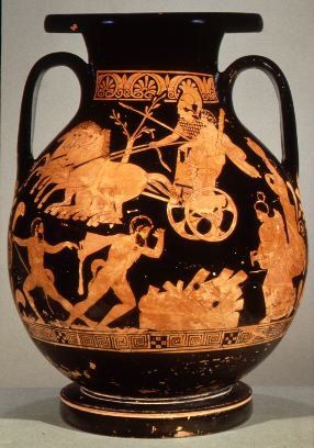
a) According to the official data, the Hill of Cronus “was wetted by a lot of snow” surely before ∼6,000 B.C. (or ∼8,000 BP). Since the last glacial advance phase in the Peloponnese (Mt. Chelmos) took place in the period 13-10 ka ( or 11,000-8,000 B.C.), then the closest in Time climatic event that would fit the description of the myth is clearly between 11,000 – 6,000 B.C. . Hence, “Hercules” travelled North after 6,000 B.C. .
b) “Hercules”, i.e. people from the Aegean, indeed travelled North during the Neolithic expansion, something well documented. They indeed reached and colonized both the “shady springs of the Danube” (Bavaria) and the “land of the Danube” (the vast region from Central Europe to the Balkans). Let’s also recall here that “the horse-driving daughter of Leto had received” Hercules. As “the daughter of Leto” is Artemis, the sister of Apollo, what the myth clearly claims is that “Hercules” knew very well where he was going and that the place had already been colonized by the Aegeans at the time of his arrival. The reference to “horse-driving” could very well be an indication of the horse’s domestication period. And since we have come to the conlcusion that Hercules’ visit took place during the Neolithic Age, this would then directly imply that horse domestication in Europe occurred (at least) during the Neolithic Age.
c) As we saw above, drier conditions and aridity indeed occurred in the Peloponnese between 4,600 – 1,400 BP (2,600 BC – 600 AD). Moreover, according to the paper titled “Middle to late Holocene palaeoenvironmental study of Gialova Lagoon, SW Peloponnese, Greece“, by Alexandros Emmanouilidis et al. (2018):
“C. During the late Holocene period (3300-2500 yrs BP) a big decline at the Rb/Sr ratio was recorded indicating dry conditions. This can be correlated with the 3500 – 2500 yrs BP Period of Rapid Climate Change (RCC) that has been recorded for the Mediterranean region by Mayewski et al. (2004) and Staubwasser and Weiss 2006 and the end of the Mycenaean state development.”
At this point, we can recall information from an older relative post.
While in the very informative paper titled “Late Glacial to mid-Holocene palaeoclimate development of Southern Greece inferred from the sediment sequence of Lake Stymphalia (NE-Peloponnese)“, by Christian Heymann et al. (2013) we read:
“Dry climatic conditions as indicated by the elemental proxies prevail until 14.7 ka cal BP and most likely represent the Oldest Dryas. Winter precipitation within the catchment is low, while summers are also dry. Between 14.8 and 14.7 ka cal BP summers become wet. There is no evidence of glaciers after 15 ka BP in the mountainous regions of the Peloponnese (Hughes et al., 2006), including Mt. Kyllini, thus changes in catchment hydrology reflect changes in precipitation and not in meltwater input.”
“A shift to humid conditions occurs around 14.7 to 14.6 ka cal BP. Winter precipitation increases, while summers are dry. After 14.6 ka cal BP, precipitation in summer also increases.”
“After 13.9 ka cal BP, climatic conditions as indicated by the elemental proxies of the Lake Stymphalia sequence become drier. From 13.9 to 13.4 ka cal BP, winter and summer precipitation is low. At 13.4 ka cal BP humid conditions in winter with dry summers reoccur and last until 13.2 ka cal BP.”
“At 13.2 ka cal BP a shift to a drier climate with low winter precipitation but humid summers marks the onset of the Younger Dryas at Lake Stymphalia.”
“The Late Glacial to Early Holocene transition is marked by a shift in Rb/Sr to a wet climate around 12.1 ka cal BP at Lake Stymphalia.”
“A climatic shift to drier conditions around 10.8 ka cal BP is indicated by Rb/Sr and these dry conditions prevail until 8.5 ka cal BP, although short-term humid winter conditions are centred around 9.8 and 8.7 ka cal BP. Between 10.5 and 8.7 ka cal BP, summers are also dry.”
“A shift to more humid summers occurs around 8.7 ka cal BP and these summer conditions prevail until 8.5 ka cal BP.”
“According to Jalut et al. (2009), various regional climates prevailed in the circum-Mediterranean during the early Holocene. Peyron et al. (2011) doubt moist conditions prevailed everywhere in the Mediterranean prior to 8 ka cal BP.”
“A short-lived shift to drier conditions can be seen in the Rb/Sr record at Lake Stymphalia centred at 8.3 ka cal BP. Both winter and summer conditions are dry. An increase in Mn/Fe centred at 8.2 ka cal BP indicates oxic/alkaline lake water conditions and points to a low lake level. This might correspond to a regional expression of the 8.2 ka event (Alley et al., 1997). The 8.2 ka event is also evident in other records from the Mediterranean region.”
“The elemental proxies indicate wet winter and summer conditions from 8 to 7.5 ka cal BP.”
“Summer conditions change after 7.5 ka cal BP to increasing dryness that lasts until 7 ka cal BP. A general shift to a dry climate is also indicated by Rb/Sr with peak dry conditions around 7 ka cal BP. Then after 7 ka cal BP, summers become wetter. Around 6.1 ka cal BP climatic conditions in winter become drier, but Rb/Sr indicates a general shift to a wetter climate around 5.8 ka cal BP.”
“Climate conditions in the Eastern Mediterranean region became more similar to the present day after 7 ka cal BP“.
Now, after having read all the above we really seem to have two options;
The first option: To conclude that all parts of the myth refer to the Neolithic Age.
The second option: Most parts of the myth refer to the Neolithic Age except the last part, which probably refers to the Mycenean Age and the great drought of the years 1200-850 BC.
Combining though all the available information (from Mythology, Archaeology, etc) we must reject the second option. The use of Hercules’ name in the myth leaves no doubt that we are not talking about the period between 1,200 – 850 BC, and this is simply because in Greek Mythology Hercules had lived well before the Trojan War. Modern Scientific Research has recently provided us a date for the end of the ‘Trojan War’, that is, on 6th of June 1218 B.C.
Hence, our Final Conclusion is that these two myths refer to the Neolithic Age, with all the implications of such a conclusion.
Research-Selection-Analysis for NovoScriptorium: Isidoros Aggelos, Philaretus Homerides, Maximus E. Niles
