
In this post we present information, sourced from officially published material, on Climate Change events in the Aegean Sea, with a special focus on the South Aegean region and the island of Rhodes.
Important note: This post is a necessary forerunner of a coming presentation on the “Cataclysmic Myths” from the island of Rhodes that Diodorus Siculus describes in detail in his “Library of History“. We decided to split this research in parts for our reader’s convenience.
(Paper 1) From the paper titled “Short-term climate changes in the southern Aegean Sea over the last 48,000 years”, by Maria Geraga et al. (2005), we read:
“(Abstract) Between 48 and 10 cal kyr BP the most pronounced stadials occurred at 41 cal kyr BP (C69-ST10) and at 13 cal kyr BP (C69-ST4). These events are characterized by: (i) high positive y18O values of Globigerinoides ruber, (ii) drops in SST and (iii) increases in aridity. These events may be correlated with the Heinrich H4 event and the Younger Dryas event, respectively. Two other stadials at 23 cal kyr BP (C69-ST6) and at 16 cal kyr BP (C69-ST5) which are characterized by increases in the abundance of the cold plaktonic foraminifera species and increases in aridity may be correlated with the H2 and H1 events, respectively. The dominant planktonic foraminiferal species during the stadials which are correlated with the Heinrich events were Turborotalita quinqueloba and Globorotalia scitula. The most pronounced interstadials occurred between 39.5 and 38.5 cal kyr BP (C69-IST6) and between 25 and 24 cal kyr BP (C69-IST3) and are characterized by depletion in y18O values, increases in SST and increases in humidity. The former event coincides with the formation of the sapropelitic layer S2.
In the Holocene the most pronounced stadial occurred between 8 and 6.5 cal kyr BP (C69-ST2), during the interruption of S1 and is characterized by a reduction in SST and an increase in aridity. The most pronounced interstadials of Holocene occurred during the formation of S1a and S1b between 9 and 8 cal kyr BP (C69-IST1) and between 6.5 and 5.5 cal kyr BP (C69-IST2), respectively. These events are characterized by depletion in y18O values, increased SST and an increase in humidity as is indicated by the expansion of temperate evergreen and Mediterranean taxa in the pollen record.”
“High resolution micropaleontological and pollen analyses in combination with y18O data, in the sediments of core C69, from the southern Aegean Sea, showed that the study area is characterized by climatic variability at millennium scale, over the last 48 kyr. The climate variations seem to correspond to cycles of stadial–inderstadials, attributed to Dansgaard–Oeschger events, although some of them differ slight in age.
Four of the recognized stadials in the Glacial period seem to correspond to the Younger Dryas and the Heinrich events H1, H2 and H4. One stadial recognized in the Holocene seems to correspond to the most widespread stadial in Holocene at 8 cal kyr BP. In most of the stadials, the isotopes, planktonic and pollen data show synchronicity, suggesting an additional operation of atmospheric processes. The climatic signal based on planktonic assemblages appears attenuated in comparison to the western Mediterranean, during the stadials which are correlated with the Heinrich events in the present study. During these events the planktonic fauna is dominated by Turborotalita quinqueloba and Globorotalia scitula.
The sapropel S1 appears in two layers (S1a and S1b). Their formations coincide with the prevalence of interstadials. The interruption and the end of S1 coincide with stadials. A sapropelitic sequence corresponding to S2 occurs between 39.5 and 38.5 cal kyr BP and coincides with the prevalence of an interstadial.”
(Paper 2) From the paper titled “Lateglacial and Holocene vegetation dynamics in the Aegean region: an integrated view based on pollen data from marine and terrestrial archives”, by Ulrich Kotthoff et al. (2008), we read:
“Late Pleniglacial (20.8 kyr to 14.6 kyr BP)
Pollen of steppe elements dominates the pollen assemblages during the late Pleniglacial interval of core SL152. This suggests that the northern borderlands of the Aegean Sea were covered by a predominantly steppe vegetation thriving under dry climatic conditions. While Artemisia and, to a lesser degree, Chenopodiaceae pollen percentages show a slight overall decrease during that time, pollen percentages of the semi-desert indicator Ephedra increase nearly constantly, reaching a maximum at around ~16.5 kyr BP. This Ephedra peak may mark the driest episode of the late Pleniglacial in the borderlands of the Aegean Sea. However, since Ephedra is also growing in coastal areas, this increase may also partly be connected to sea-level changes. Changes in wind direction could also have had influence on the Ephedra pollen signal. The interval from ~16.5 kyr BP to the end of the Pleniglacial is characterized by a decrease in steppe element pollen (SEP) percentages, whereas pollen from non-steppe herbs (especially Cichorioideae) becomes more relatively abundant. This points to a slight increase in available moisture.
(…) Given the overall dry conditions in the northern borderlands of the Aegean Sea (as indicated by consistently high percentages of SEP), populations of broadleaved tree taxa may have persisted in microclimatically and edaphically favourable niches. Broadleaved tree taxa furthermore persisted in the eastern borderlands of the Aegean Sea during the late Pleniglacial (Van Zeist and Bottema, 1991). It was however not until the end of the Pleniglacial that the percentages of non-saccate AP increased significantly in the northern borderlands. This increase, in conjunction with a strong decline in Ephedra pollen percentages, signals the onset of markedly improved growth conditions for broadleaved trees in the northern borderlands of the Aegean Sea.
The late Pleniglacial interval of core SL152 is characterized by extremely high abundances of bisaccate pollen (mainly Pinus), with maximum percentages exceeding 1000% and pollen concentrations of between 5000 and 10 000 Pinus pollen grains per gram of sediment. If bisaccate Pollen was included into the pollen sum, Pinus percentages would vary between ~80 and more than 90% during the late Pleniglacial. Such extreme percentages are not known from terrestrial records in the Aegean region.
(…) In the late Pleniglacial interval from core C69 from the southern Aegean Sea, Pinus percentages do not exceed 40% if included into the pollen sum (Geraga et al., 2005). The comparison with other marine cores indicates that the high Pinus percentages from core SL152 from the northern Aegean Sea cannot solely be explained by the over-representation of bisaccate pollen in marine sediments. Increased aeolian transport can also only partly explain this phenomenon, because core SL152 was always very close to the northern coasts of the Aegean Sea. Research from the western Mediterranean region reveals Pinus percentages higher than 90% only for one core with more than 120 km distance to the closest coastline and more than 220 km distance to the probable catchment area, while Pinus percentages are much lower for cores closer to the coastal areas (Hooghiemstra et al., 1992). Furthermore, the pollen concentration of Pinus pollen grains per gram sediment decreases to less than 1000 grains during the Younger Dryas, although the lithology and lightness values suggest no significant change in the character of the sediment, and wind direction and vigour should have been similar to late Pleniglacial conditions (Gogou et al., 2007). Therefore, we suggest an additional possible explanation: the late Pleniglacial sea level was more than 100 m lower than today, causing the subaerial exposure of extensive shelf areas in the Aegean Sea (Cramp et al., 1988; Aksu et al., 1995; Perissoratis and Conispoliatis, 2003; Figure 1). Pinus is well adapted to growing on poor, sandy soils (Oberdorfer et al., 2001). It has indeed been shown to have been the dominant arboreal taxon on the exposed continental shelf in western Canada during the late Wisconsian (Lacourse et al., 2003). Therefore we propose that the shelf adjacent to the Mount Athos Basin was populated by Pinus stands which caused an immense amount of Pinus pollen to be carried into the basin. This scenario would also explain why such extreme percentages of Pinus pollen are not reflected in coeval terrestrial archives.
(…) The substantial decrease of Pinus pollen percentages and concentrations between ~15 kyr and ~13 kyr BP, coincides with an interval of pronounced sea-level rise including meltwater pulse MWP-1A. At ~14 kyr BP, MWP-1A alone provided a sea-level rise of at least 25 m (Lambeck et al., 2002), causing the flooding of large parts of the formerly exposed shelf. In the scenario we propose for the Aegean region, this flooding caused the extirpation of the Pinus populations that had previously inhabited the exposed shelf.”
“Meiendorf/Bølling/Allerød interstadial complex (14.6 to 12.7 kyr BP)
(…) a ~200 yr long stadial, centred at ~13.8 kyr BP and characterized by increased Asteraceae, Cichorioideae and SEP percentages as well as a minimum of non-saccate AP percentages, is recorded in core SL152. This stadial appears to be the regional equivalent of the Oldest Dryas in Central Europe (eg, Litt et al., 2003) and episode GI-1d in the GRIP ice core record (Björck et al., 1998).
(…) The Oldest Dryas separates the Meiendorf interstadial from an interstadial complex lasting from ~13.7 to ~12.7 kyr BP. This interstadial complex, characterized by three non-saccate AP peaks with values up to 40%, is probably correlative with the tripartite Bølling/Allerød interval and the GRIP ice core episodes 1c3 (lower part), 1c1 (upper part) and 1a (Björck et al., 1998), respectively. Interim declines in non-saccate AP percentages associated with increased SEP percentages indicate transient climatic deteriorations in the borderlands of the Aegean Sea. The deteriorations centred at ~13.4 kyr BP and from ~13.2 to ~12.8 kyr BP appear to be coeval with the Older Dryas and Gerzensee oscillations in Central Europe (eg, Lotter et al., 1992; Ammann et al., 2000; Litt et al., 2003), and with Greenland GRIP episodes GI-1c2 and GI-1b in the GRIP ice core (Björck et al., 1998).”
“Younger Dryas (12.7 kyr to 11.7 kyr BP)
(…) The prominence of the SEP suggests that climate conditions in the northern borderlands of the Aegean Sea during the Younger Dryas were even dryer than during the late Pleniglacial.
(…) Towards the end of the Younger Dryas, a decrease in Ephedra percentages is associated with a short re-expansion of Artemisia and Chenopodiaceae (at 11.8 kyr BP). Within the next ~0.2 kyr (until ~11.6 kyr BP), the general decrease of SEP percentages and the steady increase of pollen percentages of non-steppe herbs such as Centaureaceae and Cichorioideae suggests an improved moisture availability that marks the end of the Younger Dryas in the Aegean region at ~11.7 kyr BP. Based on the pollen data from core SL152, the duration of the Younger Dryas in the borderlands of the Aegean Sea was 1.0 kyr and therefore comparable with its duration in more western settings of southern Europe (eg, Monticchio/Italy: Allen et al., 1999; Serra da Estrela/Portugal: van der Knaap and van Leeuwen, 1997) and Central Europe (eg, Brauer et al., 1999).”
“Early Holocene (11.7 to 9.7 kyr BP)
The onset of the early Holocene is marked by a major increase of non-steppe herb pollen and only a minor increase of non-saccate tree pollen percentages. It is also characterized by the first consistent occurrence of Sanguisorba minor-type pollen after ~0.7 kyr and highest pollen percentages of this taxon in the pollen record. The increasing presence of Rosaceae pollen and the dominance of Cichorioideae and Centaurea pollen, combined with low SEP percentages, point to an increase of precipitation in the Aegean borderlands. However, precipitation was insufficient to support the Holocene reforestation until ~10.2 kyr BP, as indicated by the relatively low non-saccate AP percentages (20 to 36%) prior to that time. These findings from the Aegean region are in contrast to pollen data from near-coastal settings in western Greece and Central Europe. In those regions, reforestation was already completed at ~11.5 kyr BP (Litt et al., 2001; Lawson et al., 2004; Jahns, 2005).
(…) The general increase in moisture availability at the beginning of the Holocene was interrupted by a short-term, centennial-scale setback centred at ~11.0 kyr BP.
(…) The steady increase of non-saccate AP percentages after 10.3 kyr BP culminated at ~9.4 kyr BP when ~70% was reached. This marks the completion of Holocene reforestation in the borderlands of the Aegean Sea.
(…) The increased surface water outflow from the Black Sea into the Aegean Sea after ~8.5 kyr BP (Sperling et al., 2003) may have lead to a slightly stronger pollen signal from Asia Minor, especially from the northern Turkey. At the end of the early Holocene, the strong decline in Quercus and coeval increase in Cichorioideae, Centaureaceae and Ericaceae pollen percentages between 7 and 6.5 kyr BP point to a partial opening of deciduous forests in the borderlands of the Aegean Sea. This decrease in deciduous arboreal vegetation was most probably caused by a reduction in precipitation. Climatic conditions were, however, not dry enough to support a major spread of steppe vegetation. An increase in Pinus and Abies pollen percentages from 7 to 6.3 kyr BP indicates that conifer vegetation spread in the northern borderlands of the Aegean Sea at the onset of the middle Holocene.”
“Changes in moisture availability appear to have been a prime factor controlling vegetation dynamics in the Aegean region during the last ~20 kyr. Until ~14.6 kyr BP, the borderlands of the Aegean Sea were dominated by steppe vegetation indicative of dry conditions. The Lateglacial Meiendorf/Bølling/Allerød interstadial complex exhibits a spread of broadleaved arboreal vegetation, but is also characterized by the persistence of steppe elements. This indicates that moisture availability was slightly higher than during the preceding Pleniglacial interval. During the Pleniglacial, subaerially exposed shelfal areas of the Aegean Sea were probably covered by a Pinus-dominated vegetation until flooding during the Lateglacial sea-level rise. We partly ascribe the very strong decrease of Pinus pollen percentages between ~15 and ~13 kyr BP to the particularly strong sea-level rise connected to meltwater pulse MWP-1A.
The Younger Dryas was probably the driest interval within the last ~20 kyr. Subsequent to the Younger Dryas, humidity remained insufficient to support Holocene reforestation until ~10.2 kyr. The pollen records from marine core SL152 and from Lakes Kopais and Xinias even indicate a centennial-scale vegetation setback at ~10.9 kyr BP.
During the Holocene, the vegetation experienced repeated, centennial-scale setbacks centred at around ~9.3, ~8.7, ~8.3, ~7.6, ~6.7, ~5.6, and ~4.3 kyr BP. These setbacks are marked by decreases in percentages of arboreal pollen and in some cases increases in steppe-element pollen percentages, and probably also resulted from reduced moisture availability.
The radiocarbon-based age models of previously published pollen records had implied strong discrepancies in vegetation development in the northern borderlands of the Aegean Sea, particularly for the Lateglacial to early Holocene. The well-dated pollen data from marine core SL152 allow a re-assessment of the chronologies of these records. The prominent abundance peaks of Chenopodiaceae and Artemisia during the Younger Dryas (12.7 to 11.7 kyr BP) are particularly well suited as a tie-point for the integration of terrestrial and marine records. The resulting synthesis yields a spatially and temporally consistent pattern of vegetation dynamics in the northern borderlands of the Aegean Sea.”

(Paper 3) From the paper titled “Late Glacial–Holocene climate variability at the south-eastern margin of the Aegean Sea”, by M.V. Triantaphyllou et al. (2009), we read:
“(Abstract) New micropaleontological, palynological, and geochemical results from a relatively shallow (∼500 m) sediment core (NS-14) in the south-eastern Aegean Sea provide a detailed picture of the regional expression of sapropel S1 formation in this sub-basin of the eastern Mediterranean Sea. Specifically, freshwater input during ∼10.6–10.0 ka BP has preceded the deposition of S1. Further decrease in surface water salinity is evidenced between 10.0 and 8.5 ka BP at the lower part of S1a, which in respect to S1b, is featured by warmer (∼19.5 °C) and more productive surface waters associated with dysoxic bottom conditions. A series of coolings detected within the S1 depositional interval, may be linked to outbursts of cold northerly air masses and relevant pulses in the deep-intermediate water ventilation that caused the S1 interruption between 7.9 and 7.3 ka BP and culminated during the deposition of S1b, with the decline of deep chlorophyll maximum (DCM) at ∼6.5 ka BP. The climate instability and the relevant absence of anoxia weakened the organic matter preservation in the shallow south-eastern Aegean margin during the S1 times. NS-14 record provides evidence for a distinct mid Holocene warm (up to ∼25 °C) and wet phase associated with the deposition of the sapropel-like layer SMH (Sapropel Mid Holocene), between 5.4 and 4.3 ka BP. The SMH layer could represent evidence of on-going, albeit weak, African monsoon forcing, only expressed at the south-eastern edge of the Aegean Sea. Its end is associated with the 4.2 ka BP Northern Hemisphere megadrought event and the termination of the African Humid Period at 3.8 ka BP.”
“Much interest has recently been centred on the Aegean Sea (Rohling et al., 2002b; Casford et al., 2002, 2003, 2007; Ehrmann et al., 2007; Kuhnt et al., 2007; Marino et al., 2007), because it represents an important area of deep water formation for the entire eastern Mediterranean (Zervakis et al., 2004), which appears particularly sensitive to climate forcing today (Roether et al., 1996; Theocharis et al., 1999; Zervakis et al., 2000) as well as in the past (Kuhnt et al., 2007; Marino et al., 2007). Importantly, by virtue of its location, at the north-eastern sector of the Mediterranean, in winter the Aegean Sea is under the direct influence of northerly winds (Poulos et al., 1997), thereby holding great potential as key sedimentary archive to investigate the response of the regional climate to past high-latitude forced climate fluctuations. Indeed, several recently generated Aegean paleoceanographic records suggest that – during the Holocene – short-term cooling episodes, which are bound to the strengthening of northerly winds, are superimposed on the underlying subtropical/tropical control of the regional hydrography and ecosystems (Rohling et al., 2002b; Casford et al., 2003; Gogou et al., 2007; Marino, 2008). These findings suggest that during the Holocene the eastern Mediterranean climate was less stable than previously thought.”
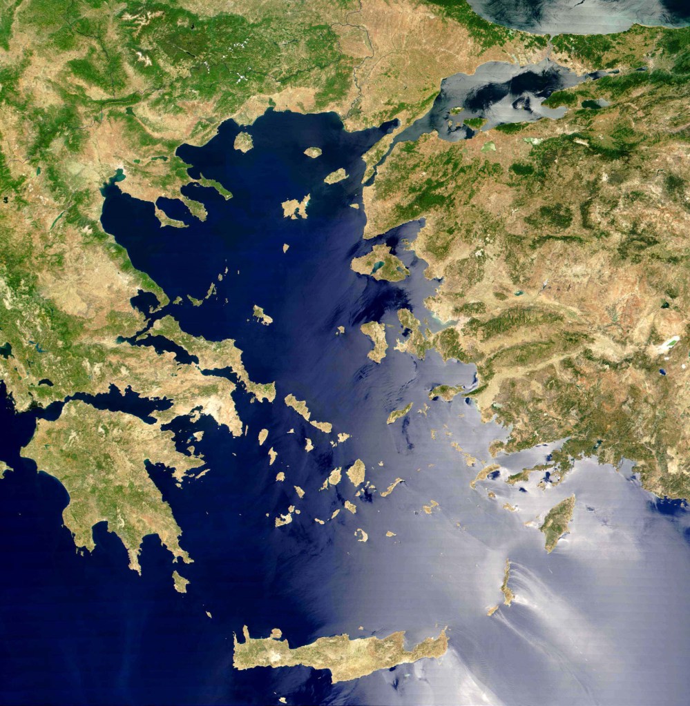
“The Aegean Sea, which is situated between Turkey and Greece, is connected with the Black and Marmara Seas through the Dardanelles Straits, and with the open eastern Mediterranean (Levantine Sea) through the Cretan Straits. The cooler (9–22 °C) and lower salinity (24–28 psu) Black Sea outflow waters flows along the east coast of Greece to reach the southwest Aegean Sea, and, due to their high nutrient contents, fuel productivity in the North Aegean Sea (Lykousis et al., 2002). The warm (16 °C in winter; 25 °C in summer) and saline (39.2–39.5 psu) Levantine surface waters flow northward along the eastern Aegean to the Dardanelles Straits (Zervakis et al., 2000, 2004). Several rivers discharge into the Aegean Sea, mostly from the north Hellenic coast and from the east coast of Turkey. Together, Black Sea outflow waters and river inputs both supply the Aegean with freshwater (Poulos et al., 1997; Roussakis et al., 2004).”
“Overall, the distribution of oxygen (and nutrients) in the South Aegean Sea is influenced by the exchange of water masses through the Cretan Straits. In the Southern Aegean Sea sediments, oxygen penetration extends to about 3–5 cm (Lykousis et al., 2002). The South Aegean sub-basin is considered as a “typical oceanic margin” environment”
“Emiliania huxleyi Moderately Calcified (EHMC) morphotypes, which are restricted to cool Holocene intervals (Crudeli et al., 2004), feature the present day Aegean during winter/spring (Dimiza et al., 2008) associated with temperatures between 16 and 19.5 °C (Poulos et al., 1997)
(…) On land, the occurrence of semi-desert taxa Ephedra and Artemisia between ∼13 and 10.6 ka BP reflects drier climate. Yet, the coexistence of deciduous Quercus and conifers imply sufficient precipitation, also reflected by the high ARs of Ter-alkanols. This should have allowed the development of forest vegetation in favourable areas. The sporadic presence of Mediterranean elements after 11.8 ka BP marks a rise in winter temperatures. (…) Taken together, these evidence suggest that during the Late Glacial cold and dry climate conditions in the (south-eastern) Aegean coexisted with well ventilated intermediate waters and, in turn, reduced preservation of organic matter. This agrees with a recently proposed scenario of intensified ventilation processes in the Aegean water column during episodes of harsh climate (Casford et al., 2003).”
“In the shallow south-eastern Aegean NS-14 core the onset of the visual S1 at 10.0 ka BP, coincides with the abundance increase of the deep and intermediate-deep benthic foraminifera infaunal taxa C. mediterranensis, G. affinis, and the oxygen deficiency indicators V. bradyii, B. alata and B. costata (Rohling et al., 1997; Kuhnt et al., 2007; Abu-Zied et al., 2008). This age fits well with the ages reported from other Aegean records (e.g. Perissoratis and Piper, 1992; Aksu et al., 1995; Geraga et al., 2000; Casford et al., 2002; Roussakis et al., 2004; Gogou et al., 2007; De Lange et al., 2008). The duration (10.0 to 6.4 ka BP) is comparable to the mean S1 duration (9.8 to 6.5 ka BP) estimated in the Aegean Sea cores in which chronologies have been accurately tested against Greenland ice-core chronologies (Rohling et al., 2002b; Casford et al., 2007).”
“Before the onset of S1 deposition (between 10.6 and 10.0 ka BP), the gradual increase of Helicosphaera spp., a coccolithophore group that is associated with lowering in salinity (Flores et al., 1997; Colmenero-Hidalgo et al., 2004), possibly indicates higher fresh water input in the core site.”
“A decline in surface water salinity is assumed between 10.0 and 8.5 ka BP by the increase of Helicosphaera spp., followed by a concomitant increase of the stratification S index mainly above 8.5 ka BP. The fresh water input in the southeastern margin of the Aegean Sea is also corroborated by the increased aquatic palynomorph concentrations. The positive shifts of the humidity H-index at our site, are attributed to an increase in regional precipitation. This interpretation is in agreement with what has been found by Kotthoff et al. (2008) in a northern Aegean record. The increased ARs of Ter-alkanols further suggest the high supply of terrigenous material, ascribed to increased land runoff.”
“The S1 interruption (7.9–7.3 ka BP) in south-eastern Aegean proves to be an interval characterised by alkenone surface temperatures that are stable around 21 °C (…) Our data from NS-14 south-eastern Aegean core show the absence of Mediterranean elements for a short interval around 7.8 ka BP representing a short period of climatic deterioration (Rossignol-Strick, 1995). A drop in precipitation during S1 interruption is featured by the decline in aquatic palynomorphs and H index”
“the increase of conifers above 7.0 ka BP, mainly attributed to Picea, is indicative of north wind outbursts (Mudie et al., 2002). Sea surface cooling during these intervals of climatic deterioration was, however, not intense enough to promote vigorous convective processes and consequently interrupt sapropel deposition. Yet, the enhanced surface buoyancy loss coupled to these events was such to disrupt the surface to intermediate water stratification. In particular, the profound decrease of F. profunda at the upper part of S1 confirms the decline of Deep Chlorophyll Maximum (DCM) throughout the Eastern Mediterranean at ∼6.5 ka BP (e.g. Giunta et al., 2003; Principato et al., 2003, 2006). More specifically, the negative shift in S index and the peak of NPP at ∼6.5 ka BP evidences lowering of stratification, most probably associated with fresh water input that is marked now by the increase of B. Bigelowii, a hyposaline and relatively eutrophic nannofossil indicator (Boalch, 1987; Negri and Giunta, 2001). A similar increase of this species has also been recorded at the same time interval in the eastern Ionian (Negri and Giunta, 2001), interpreted as stratification increase, and from the area west-southwest of Crete (Principato et al., 2003) being related to runoff conditions during a wet and cold period.”
“The presented results state that freshwater input during ∼10.6–10.0 ka BP has preceded the deposition of S1 in the SE Aegean Sea margin. Further decrease in surface water salinity is evidenced between 10.0 and 8.5 ka BP at the lower part of S1a.
(…) Our analysis confirms the absence of complete anoxia during the S1 times in the shallow south-eastern Aegeanmargin. This is due to the prevailing anti-estuarine circulation but it is also strongly linked to the recorded climate instability.”
(Paper 4) From the paper titled “Climatic forcing of eastern Mediterranean deep-water formation and benthic ecosystems during the past 22 000 years”, by Gerhard Schmiedl et al. (2010), we read:
“Our compilation of benthic foraminiferal and stable-isotope records from bathyal sites in the eastern Mediterranean Sea suggests that deep-water formation and the seasonality of food fluxes during the past 22 kyr responded sensitively to climate forcing from both the high and low latitudes. On orbital time scales, the boundary conditions for the reduction of deep-water formation (i.e., sapropel formation) were linked to the intensity of the African summer monsoon and related precipitation changes in the southern and northern EMS borderlands. The long-term changes in deep-water formation were modulated by the impact of multicentennial-to millennial-scale fluctuations of the high-latitude climate system. A series of cold and warm intervals determined the onset, interruption and termination of stagnant conditions in the different sub-basins of the EMS. During sapropel S1 formation, a bathymetric gradient and spatial contrasts in the oxygenation of deep-sea ecosystems developed. Oxygen-index values document a synchronous (within the error of dating uncertainties) collapse of benthic ecosystems and a non-synchronous and depth-related recovery associated with sapropel formation. A persistence of local deep-water formation during S1 formation is documented for the North Aegean Sea, responding to absent or reduced outflow of lowsaline Black Sea water at that time. Sapropel S1 hypoxia was particularly strong in the southeastern Levantine Sea that was likely influenced by high organic matter fluxes and related oxygen consumption rates at intermediate water depth. During the late Holocene, short-term fluctuations in precipitation over the borderlands and related changes in riverine nutrient input influenced food availability and carbon cycling in marginal basins of the North Aegean Sea and the southeastern Levantine Sea. Late Holocene deep-sea ecosystems in the North Aegean Sea reflect changes in the input of terrestrial organic matter that are linked to changes in regional precipitation and vegetation cover. At the same time, high-frequency changes in East African monsoonal rainfall and related Nile runoff controlled seasonal phytodetritus fluxes in the southeastern Levantine Sea. A dramatic drop in phytodetritus fluxes is observed around 4.2 kyr BP, attributed to a severe drought that is discussed as a major cause for the collapse of the Old Kingdom in Egypt.”
(Paper 5) From the paper titled “Late postglacial paleoenvironmental change in the northeastern Mediterranean region: Combined palynological and molecular biomarker evidence”, by K. Kouli et al. (2011), we read:
“Southeastern Aegean Sea (core NS-14)
“The pollen diagram of the South Aegean covers the last 12.0 ky. NAP values increase until 10.0 ka BP, while forestation curve exhibits its highest abundance from 9.4-8.0 ka BP, 7.2-6.2 ka BP and 5.0-4.3 ka BP. Cool temperate evergreen taxa fluctuate throughout the whole sequence, showing their lowest percentages between 10.1 and 7.7 ka BP and before 4.0 ka BP. Mediterranean elements increase at 9.4 ka, but decrease for short periods around 7.8 ka BP (S1 interruption) and before 5.5 ka BP. The calculated H-index, ranging from 0.1 to 4.5, reflects repeated wet phases centered at ~9 ka BP, ~6.8 ka BP and ~4.8 ka BP corresponding to S1a, S1b, SMH depositional intervals (Triantaphyllou et al., 2009b). T-index values (0.3-0.8) record the occurrence of increased temperature during S1a deposition (10.0-7.8 ka BP), followed by fluctuations which indicate climatic deterioration and instability (Triantaphyllou et al., 2009b).”
“terrestrial material of core NS14 originates from the surrounding islands of Kos and Nisyros as well as from the western Turkey mainland through rivers and is considered to reflect the vegetation of the SE Aegean borderlands”
“Pollen records show diversified and mixed temperate forest in the northern borderlands and enhanced Mediterranean vegetation in the southern areas document an N-S climatic trend. This is further supported by the increase in the average chain length of terrestrial n-alkanes (ACL) from the northern Aegean (av. 29.79) to southeastern Aegean and south Cretan margin sites (av. 30.06 and 30.10, respectively), suggesting a shift in the vegetation cover to warmer-climate species eastwards and southwards.
Relatively increased humidity is recorded during 20-14 ka BP in the northern Aegean, enabling the growth of cool temperate and Mediterranean trees. In contrast, drier climate was the limiting factor for vegetation development in the southern sites.”
(Paper 6) From the paper titled “Upper water column variations in the South Aegean Sea during climate change events in the last 19.000 years”, by C. Giamali et al. (2016), we read:
“Marking the transition from glacial to present-day interglacial conditions, the late Pleniglacial/Late Glacial interval (coeval with late Marine Isotope 2; MIS2) was characterized by a series of millennial-scale climate oscillations that affected the ocean-atmosphere system.”
“An abrupt shift to warmer conditions connected to the Bølling-Allerød (B-A) interstadial is indicative by all records representative of temporal climatic amelioration (Termination T1a).”
“This short deglacial event (14.8-12.7 kyr) also played an important role in the sea-level rise that produced changes in benthic foraminiferal assemblages, favoring the proliferation of shallow water species of the inner shelf.”
“An abrupt switch to cool, arid climatic event of Younger Dryas (YD) suggests a strengthening of winter convection around 12.7 kyr. This climate response of south Aegean depression to the YD event (12.7-11.2 kyr) seems to be in accordance with relevant signals from the north and central Aegean sub-basins. The latter oscillation precedes the final transition to the interglacial conditions of the Early Holocene (Termination T1b).”
“The Holocene started with a sharp warming of sea surface water, reaching present-day levels and probably associated with a reduction in salinity.”
“In this interval a brief cooling event at 7.8 kyr can be recognized mostly by the negative peak of PPC*. This brief cooling event has also been recorded in other Aegean cores. From 6.2 kyr to the top of the core, slightly heavier δ18Ο values are recorded and represent the modern water column of central Aegean Sea.”
*Planktonic Palaeoclimatic Curve (PPC)
(Paper 7) From the paper titled “Aegean Pleistocene Landscapes Above and Below Sea-Level: Palaeogeographic Reconstruction and Hominin Dispersals”, by Dimitris Sakellariou and Nena Galanidou (2017), we read:
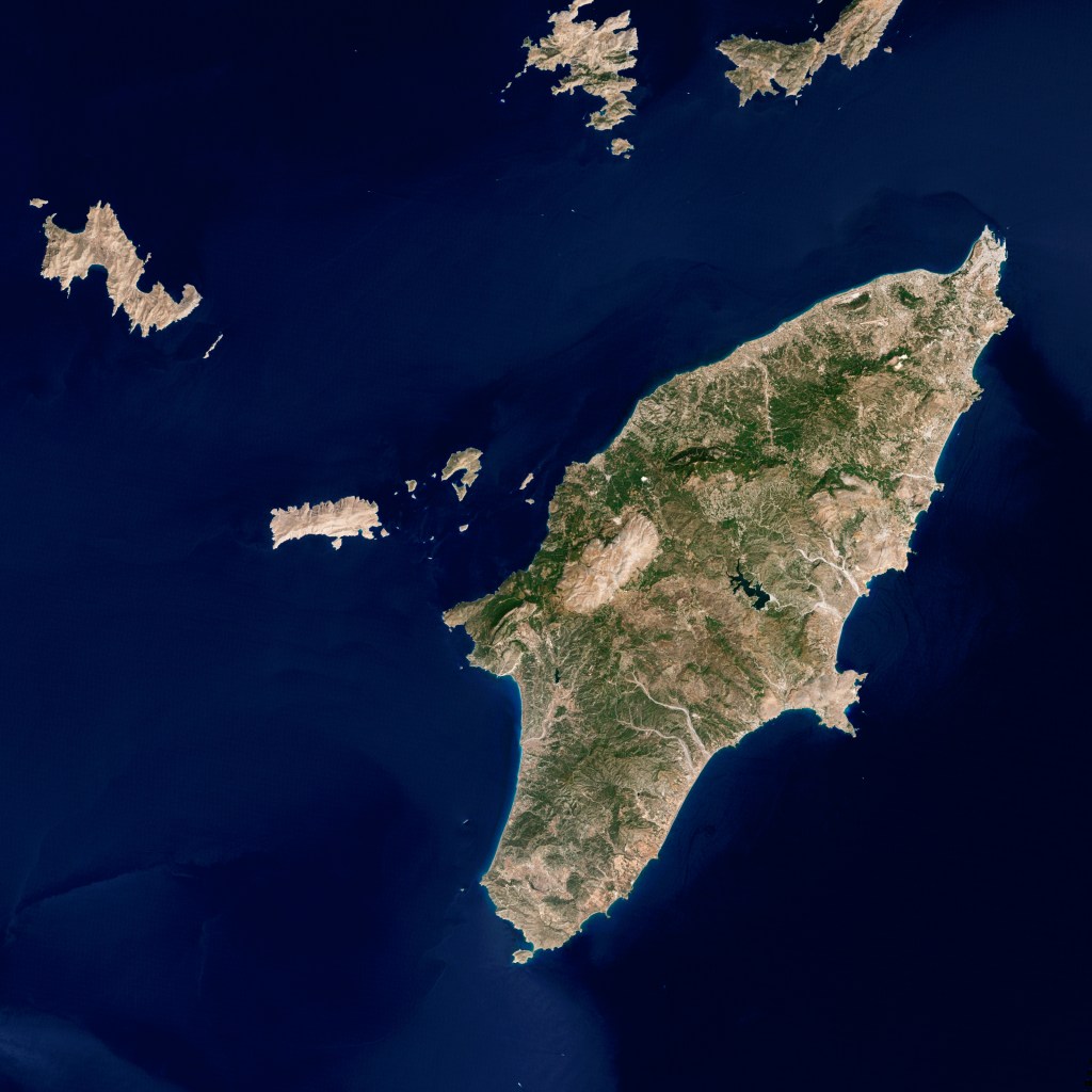
“East Cretan Strait
The islands of Kassos, Karpathos and Rhodes and some smaller ones form an island chain between East Crete and the Anatolian landmass. The islands of the East Cretan Strait represent the uplifted parts of the south-eastern segment of the Hellenic Arc, which is characterized by active strike-slip tectonics (Jongsma 1977; Mascle et al. 1982) and oblique thrusting (Stiros et al. 2010). Subsequent deformation and uplift of the Arc creates extensional tectonics of the upper plate, manifested by numerous normal and oblique faults (Ten Veen and Kleinspehn 2002). The East Cretan Strait is segmented into tectonic blocks, each with its own history of vertical movements. The island of Rhodes is characterised by a number of crustal blocks (Pirazzoli et al. 1989), each with a different tectonic history and with up to eight Late Holocene shorelines (Pirazzoli et al. 1982, 1989; Kontogianni et al. 2002). Despite the general uplift of the entire island there are still areas which exhibit submergence during the Late Holocene (e.g., the submerged Roman quarries at Koskinou) and which are separated from the uplifting blocks by normal faults.
The three main islands are surrounded by narrow shelves. The sea-strait between Rhodes and Turkey is shallow and it is possible that the island was connected to Anatolia during earlier low sealevel periods. Karpathos and Kassos Islands were connected to each other during low sea-level stands but were always separated from Crete and Rhodes by deep sea straits.”
(Paper 8) From the paper titled “Paleoecologic and neotectonic evolution of SE Rhodes (Greece) during the early Pleistocene”, by Yvonne Milker et al. (2019), we read:
“The recent Eastern Mediterranean Sea is characterized by oligotrophic conditions but little is known whether trophic conditions were comparable in the northeastern Mediterranean Sea region during older time periods such as the early Pleistocene. The Neogene climatic and hydrologic evolution of the Eastern Mediterranean Sea is influenced by orbital changes, leading to the periodic deposition of sapropels. The sapropels formed at times of Northern Hemisphere summer insolation maxima and are linked to phases of enhanced African monsoon activity (e.g., Hilgen, 1991; Rossignol-Strick et al., 1982) resulting in changes in the oxygenation of bottom and pore waters. Changes in trophic conditions and oxygenation of bottom and pore waters, in turn, influence the distribution and microhabitats of benthic foraminifera, particularly in deep-sea environments (Jorissen et al., 1995).
The Eastern Mediterranean Sea is tectonically active since the late Cretaceous closure of the Tethys where the African plate is subducted beneath the Anatolian plate along the Hellenic trench and its eastern extensions, the Pliny and Strabo trenches. In this geotectonic context, the island of Rhodes has been affected by two long-term subsidence and uplift phases, one in the early and one prevailing middle Pleistocene, and counterclockwise/anticlockwise rotations in the Plio- and middle Pleistocene (e.g., Van Hinsbergen et al., 2007; Cornée et al., 2019). The early Pleistocene neotectonic evolution of the eastern part of the island of Rhodes is recorded in various onshore sedimentary units consisting of marine sediments. These sediments reflect large-scale subsidence and uplift phases in individual and mostly fault-bound paleo-valleys, although remains unclear to what extent the different paleo-valleys underwent diachronous tectonic motions (e.g., Cornée et al., 2019). “
“We found a high and constant concentration of eutrophic/low oxygen tolerant species in conjunction with a generally high diversity in the Pefka E sediment section. This observation suggests that mesotrophic conditions, with well oxygenated bottom waters, prevailed in the NE Mediterranean Sea region during the early Pleistocene which is in contrast to the recent oligotrophic conditions. The higher food availability might be the consequence of enhanced riverine nutrient influx into the Rhodes basin which led to increased surface productivity and related organic matter fluxes during the early Pleistocene. We further orbital-driven fluctuations in the individual abundances of the most important benthic foraminiferal species. Obliquity-driven changes were found in the relative abundance of Cassidulina carinata s.l. in the upper part of the section and are related to a higher food availability during glacial compared to interglacial periods in the Eastern Mediterranean region. Precession-driven changes were observed in the relative abundances of C. carinata s.l., Cibicidoides pseudoungerianus and Cibicidoides mundulus. These changes likely reflect enhanced rain fall and associated prolonged near-coastal phytoplankton blooms at times of Northern-Hemisphere insolation maxima. Most the early Pleistocene deep-sea sapropel intervals are characterized by an increase in eutrophic/low oxygen tolerant taxa and a decrease in oligotrophic taxa in the studied section. This suggest a higher and seasonally prolonged riverine runoff and associated phytodetritus fluxes rather than dysoxic conditions at the sea floor at estimated water depths between ~200 and ~600 m during times of sapropel formation in the Eastern Mediterranean deep-sea basins.“
NovoScriptorium: Now, let us recall one of our previous posts which is strongly related with this one.
As it is rather clear from the information presented in this post, too, there is hardly any doubt that the inhabitants of the Aegean as a whole, North and South, had experienced a series of “Cataclysmic events” during the Early Holocene. These events had been recorded in their collective memory and survived Time in ancient texts known as “Greek Mythology“.
We will not tire to repeat that once this Mythology was considered by the Greeks themselves as their “National History“, there can be hardly any doubt from our part that the Classical Greeks were direct descendants of the Mesolithic/Neolithic inhabitants of the same region (Greek peninsula and the Aegean).
What is equally important is that several Myths appear to contain accurrate descriptions of climatic or astronomical phenomena of the distant Past; these can be used by modern scientists in order to calculate, with satisfying accurracy, the time (or time interval) when several stories of this Mythology actually took place.
Concluding this presentation, we suggest a read of the following posts: 1, 2, 3.
Research-Selection-Comments for NovoScriptorium: Philaretus Homerides, Isidoros Aggelos
